ArcUser Online
Troubleshoot Joins
ArcGIS 10 tool identifies join errors beforehand
The Validate Join button was added to the Join Data dialog box at ArcGIS 10 to troubleshoot joins before you make them.

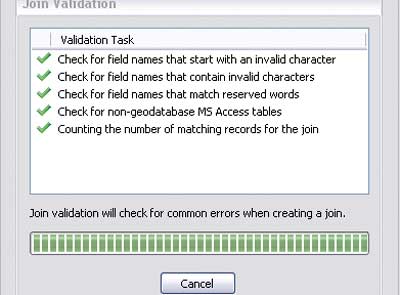
The Validate Join tool reviews four common sources of table join errors.

The Validate Join button was added to the Join Data dialog box at ArcGIS 10 to troubleshoot joins before you make them.
This article as a PDF.
In ArcGIS 10, it is easier to avoid common problems encountered when creating a join between two tables in ArcMap.
The most common reason for joining tables is to display nonspatial data in ArcMap. For example, you might have a layer containing point features that supply the location of cities and a separate table with characteristics about those cities, such as population or spending habits, that you would like to symbolize on the map. There are two kinds of joins: spatial and tabular. A spatial join is based on the location of features in two layers. A tabular join is based on a field common to both tables. Validate Join deals only with tabular joins.
The Validate Join button, available when Join attributes from a table is selected on the Join Data dialog box, triggers analysis of the two participating datasets to determine if
- Any field names start with an invalid character (`~@#$%^&*()-+=|\\,<>?/{}.!'[]:;_0123456789)
- Any field names contain an invalid character (`~@#$%^&*()-+=|\\,<>?/{}.!'[]:;)
- Any field names match reserved words based on the underlying DBMS (For example, in Microsoft SQL Server, COMMIT and ROLLBACK are reserved words.)
- There are nongeodatabase Microsoft Access tables
If these problems are present in the tables to be joined, ArcMap can display null values in attribute tables or report misleading selection or record counts. Validate Join analysis checks for invalid characters when analyzing coverage data but excludes these character symbols: the number sign (#), the dollar sign ($), and the hyphen (-). It also excludes the period (.) when checking for invalid characters for ArcSDE software-connected data. However, it will report the presence of these characters as well as the number of matching records for the join.