October - December 2004
October - December 2004 |
||||||||
|
|
||||||||
Of the many natural hazards facing the Great Plains today, drought still remains the most difficult to quantify, delineate, visualize, and quickly interpret in maps. Drought boundaries are diffuse. The episodes emerge, evolve, and migrate, often ignoring major physiographic breaks in the landscape. Farmers many hundreds of miles away from the actual drought event can be impacted. Droughts can be classified as meteorological, agricultural, hydrological, or socioeconomic, as outlined by Richard R. Heim Jr. of the National Oceanic and Atmospheric Administration. Each type of drought differs in geospatial and temporal contexts. In Nebraska, drought has a significant impact on individual farmers and their communities. Although crop losses in 2002 and 2003 eclipsed a half billion dollars in Nebraska, these numbers do not reflect the consequent impacts on animal production, food processing, tourism, recreation, and local community water supplies. Often, mapping drought means mapping the flow and history of water on the landscape. Data on the many types of drought and their characteristics is available from multiple sources. Federal or state agencies often maintain independent geospatial databases for environmental monitoring. This forces the public to query multiple Web sites to obtain data from stream flow gauges, weather stations, and groundwater wells. As a consequence, users cannot conveniently integrate these related drought parameters and monitoring network data into information for mitigation and emergency response.
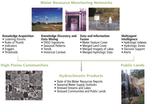
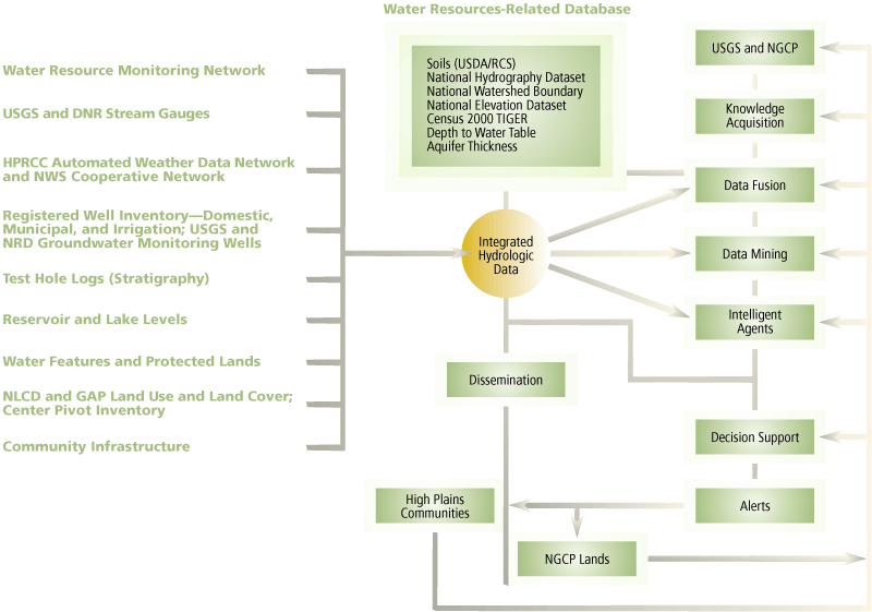
As Internet-based water information resources grow dramatically, integrating, customizing, accessing, and analyzing multiple environmental monitoring networks and synthesizing the daily measurements in new visualizations and interpretations of drought events are critical components of emergency response systems for the United States Department of Agriculture (USDA), National Weather Service (NWS), and United States Geological Survey (USGS). New Web-based GIS tools are needed to capture and integrate this data. For Nebraska farmers and federal policy makers, the authors are developing a suite of drought index tools and new visualizations using Esri software to describe the geography of water and the temporal and geospatial context of drought events and to derive new hydrologic interpretations that characterize the behavior and trends of streams and water basins. Geographic ScopeWater is a strategic resource to Nebraska's agriculture and its rural communities. Nebraska ranks second in the nation in total irrigated croplands with more than eight million acres. Nearly 86 percent of irrigated acres rely on groundwater and the remaining 14 percent represent surface water irrigation. Despite the reliance on groundwater resources, the hydrologic unit concept described in a 1987 USGS report, Hydrologic Unit Maps, by P.R. Seaber, F. Paul Kapinos, and G.L. Knapp, is still a useful framework for comparing stream behavior, irrigation, cropping systems, and land use and land cover as well as describing drought vulnerability. [The hydrologic unit concept divides and subdivides the United States into successively smaller areas-region, subregion, accounting unit, and cataloging unit-that are denoted by Hydrologic Unit Codes (HUCs). HUCs uniquely identify each area and consist of two to eight digits based on the four levels of classification in the hydrologic unit system.] In Nebraska, there are 69 hydrologic units delineated at the eight-digit level. The Geospatial Framework of IJEDIThe starting point for the project's analysis is a set of water basins. Each water basin has unique hydrological characteristics. It is represented by a set of distinct parameters and has a set of surface water (SW), groundwater (GW), and weather stations that measure different aspects of the hydrological state of the basin. This allowed authors to perform comprehensive knowledge discovery and data mining analyses on the data for each basin. By combining statistical analyses and domain expertise, the project's goal was to identify useful patterns and distinct trends. The authors wanted to find rules that would describe each water basin uniquely, indicate the quality of data within a water basin, and allow the classification of water basins into groups with similar hydrologic behavior. The GIS layers shown in Figure 1 were used to relate observations, patterns, cause-and-effect links, norms, and outliers with roads, streams, lakes, and counties. DatasetsThe project draws on many national geospatial datasets to provide ancillary characteristics for hydrologic units, public lands, and communities. These datasets include the State Soil Geographic (STATSGO) Database for Nebraska (USDA/Natural Resources Conservation Service, 1994), the National Elevation Dataset (USGS/Earth Resources Observation System, 1999), the Cropland Data Layer of USDA's National Agricultural Statistics Service (USDA/National Agricultural Statistics Service, 2002), and U.S. Census TIGER 2000 Data. These datasets vary in scale, resolution, extent, and format. Continued on page 2 |