ArcWatch: Your e-Magazine for GIS News, Views, and Insights
September 2011
New ArcGIS Online Subscription Coming Soon
Organizations Can Get More out of ArcGIS Online with New Esri-Hosted Cloud Services and Customization
Does your organization want to use secure and cost-effective hosted cloud services to create and publish maps and manage and share geographic information?

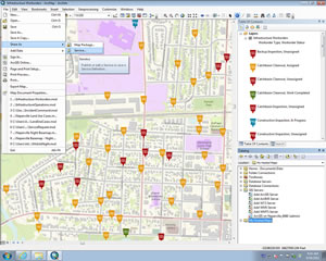
In ArcGIS 10.1 for Desktop, users will be able to publish a service directly to ArcGIS Online without the need for server software.
These capabilities will soon be provided by Esri's new subscription-based cloud services, which will be available later this year through ArcGIS Online.
ArcGIS Online subscriptions will benefit organizations, especially those with limited resources, by simplifying access to maps and data and by making it easy to publish and manage geographic content on the web. Subscribers will be able to quickly unlock their GIS data and make it available to anyone using a desktop, a web browser, or a mobile device such as a smartphone or tablet.
Esri will add new capabilities to ArcGIS Online that, for a fee, will let you
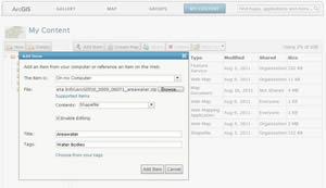
- Publish map services and datasets without the need for server software.
- Provide organization-wide access to your maps and data.
- Control access, user roles, and content sharing.
- Customize the look and feel of your ArcGIS Online home page, including featured gallery content.
These new capabilities will help make maps and data more accessible and allow you to share geographic knowledge internally as well as with colleagues outside your organization such as business partners, customers, and the general public.
ArcGIS Online supports multiple open standards on the web and when fully integrated with ArcGIS, increases what you can do with your organization's GIS. It already provides thousands of authoritative, ready-to-use maps and tools, to which your organization can now add its own content and publish and manage it cost-effectively in Esri's cloud environment. With the ArcGIS Online new subscription plans, organizations will be able to publish maps and data in the Esri cloud without other server software. This means your organization won't have to purchase any additional server software or other resources to publish web services or expand its existing publishing capabilities. Maps and data that are published as web services are more easily accessible to others, including knowledge workers and decision makers, regardless of a user's location or device.
Published as feature or tile services, the web services are managed and hosted in Esri's secure cloud environment. Access to these services can be scaled to meet demand without any effort on an organization's part. For example, using ArcGIS Online, a city hosting a sporting event can publish a map showing where the event is being held and other related information. Visitors to the event site may number in the tens or hundreds of thousands. Whatever the volume, the service workload is automatically managed and distributed by Esri's cloud infrastructure. This significantly reduces content publishing obstacles and organizational resource constraints. Organizations will be able to focus on making maps, data, and GIS functionality, such as drive times, proximity searches, and other analyses, available to anyone who needs them, either within the organization or outside it including the general public.
Your organization will be able to set up an account that is controlled and monitored by your designated administrator or administrators. An administrator can manage and control the organization's content and decide which items should be kept private, shared only with specific groups, or made public. The administrator also provisions user access and roles, sets up groups so members can collaborate on special projects, and manages the groups' memberships and content.
For example, your organization may wish to have 10 publishers and 25 users in an account. Publishers can author and publish hosted map services, whereas users can consume this content and use it to create and share new maps. Your administrator will be able to use subscription management tools to monitor the use and storage of items that have been published to the cloud, such as the number of times a service is being accessed and the storage capacity used.
You can also personalize the look and feel of ArcGIS Online to fit your organization's brand. For example, you can set up a custom home page and add your organization's logo, name, and description. You can also decide what maps and apps should be featured in the galleries and choose the default basemap that appears in the map viewer. You can add your own basemaps and other operational maps and feature them in the galleries as well. Your organization can easily find the maps that are most appropriate for each user—on demand and in a self-serve environment.
The new functionality offered as part of the subscription will be accessible through ArcGIS 10.1 for Desktop, the ArcGIS map viewer, and ArcGIS Explorer Online. Organizations will be able to purchase monthly or annual subscriptions based on the number of users, storage capacity, and page views.
ArcGIS Online subscriptions will be in beta in fall 2011. To learn more, register for a free webinar to be held on December 6, 2011.
