The Strauss Center Uses Esri Technology to Better Target Aid
Mapping Tool Provides Insight into How Climate Change Is Affecting the Security of African Nations
March 27, 2012
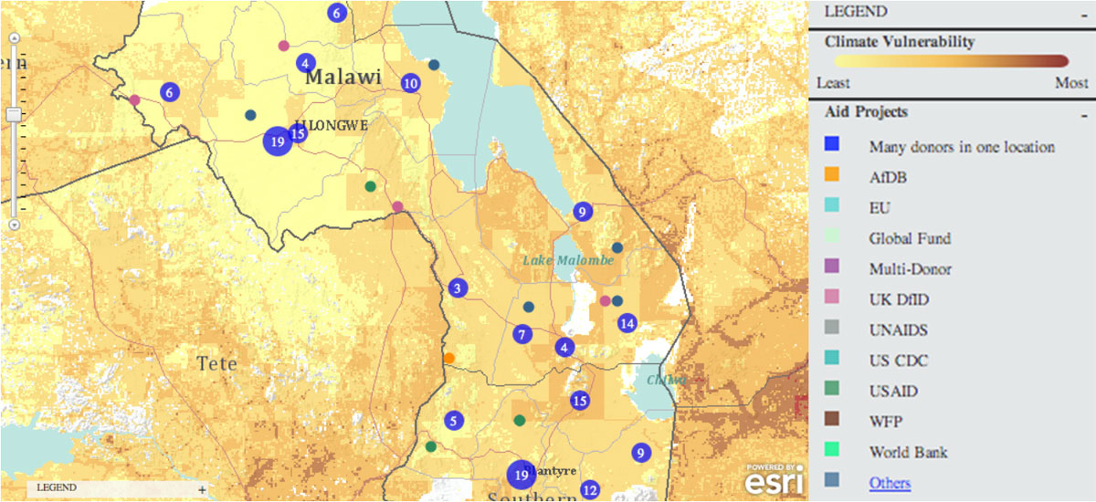
Active Aid Projects in Malawi
Redlands, California—The Strauss Center's Climate Change and African Political Stability (CCAPS) program has implemented Esri technology to view how climate change impacts vulnerable populations in Africa. CCAPS created the dynamic mapping tool in partnership with AidData for use by researchers, policy makers, journalists, and citizens. Users can visualize any combination of CCAPS data on climate change, conflict, and aid on a map to discover how different forces overlap or intersect.
"This mapping tool allows policy makers to analyze data from multiple sources at once, providing integrated analysis of the drivers and responses related to security risks stemming from climate change," said Francis J. Gavin, director of the Strauss Center.
The tool is already being used in the country of Malawi for a solution that tracks and reports on the country's external funding. Aid information is mapped along with data on climate change vulnerability and incidents of conflict. This sheds light on whether aid is effectively targeting regions where climate change or conflict poses the most significant risk to the sustainable development and political stability of the country.
"Climate change poses an enormous threat to the livelihoods of millions of Africans," said Jean-Louis Sarbib, CEO of Development Gateway. "The level of risk, however, is not evenly spread and certainly doesn't respect national boundaries. To ask critical questions about how development assistance can reduce vulnerability, you need hyperlocal data on climate and also on aid-funded interventions. This is what the new CCAPS mapping tool shows in a digestible, interactive way."
By integrating CCAPS research on climate change, along with existing datasets such as topographic maps, imagery, and thematic information on conflicts, the CCAPS mapping tool aims to provide the most comprehensive view possible of climate change and security in Africa.
"The great work of these organizations is a real game changer for the development community," said Jack Dangermond, president of Esri. "Being able to create a tool that allows people to communicate with others all over the world using maps is powerful. I am impressed with the work being done and excited to see what they will think of next."
CCAPS and AidData will continue to release upgrades to the mapping tool throughout 2012. The current mapping tool is available to use now at www.strausscenter.org/ccaps/mappingtool. For more information on AidData, go to www.aiddata.org. Learn more about GIS solutions for climate change from Esri at esri.com/climate.
# # #
About the Strauss Center
Funded by the US Department of Defense's Minerva Initiative, the Strauss Center's program on Climate Change and African Political Stability aims to assess where and how climate change poses threats to stability in Africa, develop strategies to build government capacity to respond, and evaluate the effectiveness of foreign aid for climate change adaptation in Africa. For more information, please visit http://ccaps.strausscenter.org.
About AidData
AidData is a collaborative initiative to make information on development assistance more transparent and accessible. The AidData team works with a range of partners to geocode development activities, create data visualizations, and explore new ways to collect and standardize information about development projects around the world. AidData is a joint program of Brigham Young University, the College of William and Mary, and Development Gateway. For more information, visit www.aiddata.org.
Press Information:
Karen Richardson, Esri
Tel.: 909-793-2853, extension 1-3491
E-mail (press only): press@esri.com
General Information: info@esri.com