In 2024, the National Statistical Institute (NSI) in Tunisia will count all 11.5 million people living in the North African country. As in many other countries, conducting the census is the most intense and expensive peacetime operation that occurs in Tunisia. The process relies on tens of thousands of fieldworkers and requires a big budget—it cost about 40 million Tunisian dinars (approximately US$13 million) to administer it in 2014.
To make the count easier and more efficient, a team of IT engineers and GIS enthusiasts at NSI has instituted Air Stat, an initiative that aims to automate census surveys and their related statistical processes. But instead of having this revolve around developing a bunch of apps from scratch, the engineers working on the project made it their goal to have Air Stat integrate cutting-edge technologies, such as cloud computing, mobility, and web and mobile GIS, as building blocks for design. This way, the IT engineers can easily assemble agile and secure solutions—without getting bogged down in coding—that can automate any mobile or web-based survey and statistical process from sampling to dissemination.

The project, which began in 2014, is part of a United Nations-financed initiative to use mobile technology in statistical processes in countries in Africa. NSI has already deployed Air Stat for use in other, smaller surveys taken throughout Tunisia, and the organization is realizing the benefits of having better-quality and more secure data, not to mention faster processes for getting field data into NSI’s databases and ready for analysis.
What really made all this possible was the release of the new generation of ArcGIS Enterprise (10.5.x and 10.6.x), since that enabled the engineers to implement and deploy an array of functionality quickly, encased within a few key pieces of ArcGIS technology. Now, NSI is gearing up to deploy its solutions in full for the 2024 census.
The Building Blocks of Successful Enumeration
For Air Stat to work, it relies on three key building blocks: the cloud, enterprise mobility management (EMM), and web and mobile GIS.
The very first building block NSI engineers tested and deployed was a private cloud. They knew that field staff would need access to NSI’s local storage, servers, data, and apps anytime, anywhere, and that it was essential that everyone have granular access control to protect sensitive data while facilitating productivity.
The engineers also wanted to ensure that NSI staff could remotely manage and provide security for the mobile census fleet. This is where the EMM building block comes in, which encompasses managing mobile devices, apps, and data. The team chose to implement a per-app virtual private network (VPN), which encrypts data on an app-by-app basis rather than encrypting all the data moving between the field devices and NSI’s internal servers. The IT engineers also designed the system so that specific types of users have profiles that are tied to distinct apps on their devices. Enumerators, for example, get Survey123 for ArcGIS automatically installed on their devices—and only that app can access NSI’s internal servers—while the chief enumerators’ devices automatically get Collector for ArcGIS. Now, thanks to the EMM and the new generation of ArcGIS Enterprise, during the census, NSI will know exactly where its mobile devices are and will be able to do things like send notifications directly to device users, remotely install and uninstall apps, sync field-collected data both online and offline, and remotely wipe the devices.
The third building block for Air Stat is web and mobile GIS. The engineers wanted NSI’s apps to be map oriented and customizable, with the ability to collect any kind of geographic information needed. Additionally, because NSI manages such a huge workforce during the census, the team knew it would need to develop real-time dispatching capabilities and interactive, real-time dashboards. The apps would need to be functional on multiple platforms—including iOS, Android, Windows, and the web—and able to work in numerous languages. Luckily, these requirements were met by deploying Esri’s suite of field apps, including Collector, Survey123, a data validation app built with Web AppBuilder for ArcGIS, Operations Dashboard for ArcGIS, and Workforce for ArcGIS.

NSI’s building blocks are continually expanding, but to ensure that all these functionalities are in top form by the time the census rolls around, the organization has already implemented Air Stat in several other Tunisian surveys. For example, the civil registration survey, which continually records births, marriages, and deaths, now has secure remote access, so the data moving between remote workstations and NSI’s internal servers is encrypted. The country’s 2018 Multiple Indicator Cluster Survey (MICS6), a household survey supported by the United Nations Children’s Fund (UNICEF), employed secure and automatic online/offline synchronization. And the country’s complex quarterly labor force surveys, which is what Air Stat is currently predominantly used for, now utilize map-oriented apps, the form generator for questionnaire-like apps, automatic deployment, online and offline syncing, workforce management, real-time and interactive dashboards, and spatial analysis.
Effective App Implementations and Continued Development
With Tunisia’s next census just five years away, NSI is at full throttle in testing, perfecting, and releasing its survey, data gathering, data validation, workforce monitoring, and spatial analysis functionality and apps.
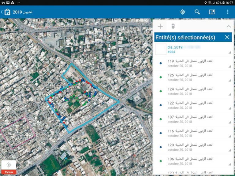
The organization’s questionnaire-oriented app, which was built using Survey123, is being used consistently by enumerators for the labor force surveys to collect data from households and all their members. Use of the app ensures ongoing data consistency and coherence and allows NSI staff to visualize the households and their data on a map. So far, NSI has collected almost 100,000 of these complex surveys using this app—most of which contain more than 200 questions with complicated conditional logic and related tables.
Through the labor force survey, NSI has also gathered more than 400,000 data points using its map-oriented app based on Collector. With this app, chief enumerators can record and update any kind of geographic information, including points, lines, polygons, tables, and questionnaires. They can draw and fix geographic shapes, such as buildings, districts, and routes. They can also launch preselected questionnaires that already have some fields filled out. All this data and its related tables can be reliably synced to NSI’s internal servers once they are collected.
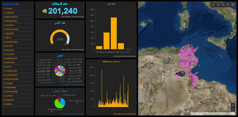
In addition, the engineers used Operations Dashboard to set up an interactive, real-time dashboard that allows NSI staff to monitor in-progress surveys, seeing incoming data, key performance indicators, where fieldworkers are located, and more. They can also filter this data at the national, governorate, district, and even enumerator levels.
Development work isn’t done, however. The engineers are currently conducting preliminary tests on Workforce, which will allow NSI to dispatch and manage fieldworkers based on survey, district, date, priority, and enumerator. This will help NSI manage simultaneous surveys, coordinate related field operations, and avoid conducting conflicting visits at the same households. They are also actively exploring how to do spatial analysis of the collected data using ArcGIS Pro, Insights for ArcGIS, and other Esri technology.
Making Headway Toward a Smooth Census
While not all the technological kinks have been worked out quite yet, NSI is making promising progress toward its goal of having agile and secure solutions available for Tunisia’s 2024 census that will automate many enumeration-related activities and make the count—and the ensuing statistical analysis—as smooth a process as possible. For more information, email Nejib Elkhelifi, NSI’s lead for the Air Stat initiative, at elkhelifi.nejib@ins.tn.


