
The S-Bahn opened in Berlin, Germany, in 1924 as an elevated light-rail system that complemented the city’s underground U-Bahn rapid transit network.
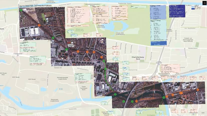
Part of the S-Bahn was the privately constructed 2.8-mile Siemensbahn link, which included three additional stations. This link was built to serve Siemens employees working at the company’s Siemensstadt facility, which featured a town with related amenities. Because Siemens AG relocated its headquarters to Munich in 1948, both the Berlin facility and the Siemensbahn S-Bahn link were eventually decommissioned in 1980.

In 2018, Siemens AG announced the construction of a new campus at Siemensstadt for research purposes. Included in these plans is the reactivation of the Siemensbahn light-rail system, which is scheduled for completion in 2029. The German national railway company, Deutsche Bahn AG, is overseeing the project. Because the central section of the track is considered a historical landmark, planning was challenging.
In preparation for the renovation work, Esri partner ARC-GREENLAB created 3D building information modeling (BIM) models of one of the Siemensbahn link stations, Wernerwerk, and its steel viaduct that would carry the train. The team at ARC-GREENLAB used ArcGIS GeoBIM, ArcGIS Online, and ArcGIS Pro to develop the models.

“Because of its age, it was necessary to recalculate the entire structural analysis of the viaduct and terminal building in the development of the as-built models,” said Fabian Götzel, the team lead for computer-aided design (CAD) and BIM at ARC-GREENLAB. “This is an 800-meter section [of the viaduct] with 48 steel [columns holding up] a double track rail [line]. It includes the platform of Wernerwerk station with the reception building, roof, stairs, and related terrain.”
Deutsche Bahn used the as-built models as a basis for creating subsequent models for the planning and construction required to refurbish the station and viaduct.
“The reopening of the Siemensbahn is part of an extensive urban redevelopment plan in northwest Berlin,” said Hans-Martin Krausmann, the CEO of ARC-GREENLAB. “To develop new neighborhoods for residential use and economic development, public transportation is also set to be significantly expanded and upgraded.”

Gathering Data and Building the 3D As-Built Models
To model the existing viaduct and station, ARC-GREENLAB team members collected terrestrial laser scan data using the RTC360 laser scanner from Esri partner Leica Geosystems. They then took the scan data and used ArcGIS Pro to create a point cloud. This required more than 1,200 scans. The team also used tachymeters—surveying devices that help rapidly determine distance, direction, and elevation differences—and drones to ensure that the data was highly accurate.
ARC-GREENLAB acquired GIS and BIM data from the City of Berlin, including a one-meter digital terrain elevation model, parcel data, and Level of Development (LOD) 200 building models to help determine spatial relationships. The LOD rating system defines the level of detail and accuracy in a BIM model throughout a project’s life cycle. For LOD 200, the design is refined enough to show various elements’ approximate quantity, size, shape, and location.
This foundational data provided details about the station’s original construction to guide renovation efforts. The team converted the LOD 200 building models into the Industry Foundation Classes (IFC) format so that the data could be used in the as-built BIM models.

The ARC-GREENLAB team also surveyed Wernerwerk station’s foundation, columns, and steel beams, as well as the concrete footings on which structures stand. Team members collected data on service passages, railings, and drainage channels as well. On average, 3,000 individual parts were modeled per steel column. The team then verified the information, such as rivet patterns, the thickness of the steel, and plate dimensions, to identify any structural issues, including existing deformations.
Further Refining the Models for Planning and Construction
After completing the 3D as-built models, the ARC-GREENLAB team used them to create more refined BIM models for planning and construction processes. Team members prepared the data for the models by producing layers and then 3D scene layers using ArcGIS Pro. They then published the scene content to ArcGIS Online for sharing with project stakeholders over the web. After publishing to the web, they linked to georeferenced Autodesk Revit and CAD files stored in Autodesk Construction Cloud in a single, connected data environment using ArcGIS GeoBIM. This enables access to unified GIS and BIM project content through a centralized point of entry.

The team noted any planning issues in the models, such as existing structure deformations, and presented these in a dashboard made with ArcGIS Dashboards, as well as in an ArcGIS GeoBIM app to increase user accessibility among surveyors, planners, contractors, and engineers. Once construction begins, additional stakeholders can be invited to use the applications. The planning and construction models are developed simultaneously because any changes made to the planning model, in turn, affect the model developed for construction. Any issues that are found can be resolved in Autodesk Construction Cloud.
The planning and construction models are highly detailed at LOD 400. They include comprehensive representations of components that can be used for assembly planning and development. The precise model information available in LOD 400 allows the team to calculate the costs of the work as well.
“The planning and construction models are also used to verify any new structural calculations,” said Götzel. “Identified issues in the calculations are assigned to their respective BIM model in the [Autodesk Construction Cloud] environment, and the person that identified the issue is notified when the necessary changes are made to the design. As a comprehensive project platform, ArcGIS GeoBIM provides access to relevant data for other stakeholders involved in the project.”
Strengthening Collaboration and Decision-Making
The use of ArcGIS GeoBIM assures those involved in the Wernerwerk station renovation that actionable issues are clearly presented through visualizations and are synchronized with Autodesk Construction Cloud. This enables interdepartmental collaboration and decision-making.
-
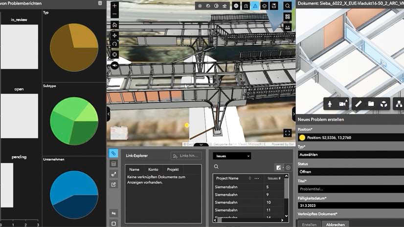
ArcGIS GeoBIM enables a cloud-to-cloud connection between ArcGIS and Autodesk Construction Cloud.
Since the BIM models are geospatially enabled through ArcGIS GeoBIM, they can be used for different analyses, such as those that determine topographical variations and soil composition to ensure the stability of construction. In addition, because of the extensive datasets available, the team can design and implement other analyses in ArcGIS GeoBIM as needed. This allows a greater number of stakeholders to benefit from the data and capabilities provided by the BIM models.
“The use of BIM has huge growth potential in the construction sector,” Krausmann concluded. “When working with BIM models, one of the biggest challenges is linking the Autodesk data world with the spatial context in GIS. Thanks to ArcGIS GeoBIM, this can now be easily implemented. This project shows how well ArcGIS GeoBIM can be integrated into typical workflows in [architecture, engineering, and construction].”