What if you could rewind a forest fire, fast-forward a coral bleaching event, or test drive a species reintroduction? The most powerful tool in modern conservation is no longer a drone, a GPS tracing device, or a geofence—it’s a digital twin. Digital twins give conservation scientists and practitioners a virtual mirror of the planet where they can experiment, fail, and fix things before reality catches up.
A digital twin is a dynamic, data-driven representation of a physical system. In GIS, most digital twins represent human systems like airports and cities. Around the world, these digital twins enable decision-makers to test solutions, get early warnings about problems, and prioritize where and when to invest resources.
But what about environmental systems that power the planet? These systems are under immense pressure from land use, rising sea levels, extreme weather, drought, floods, and more. Conserving nature and biodiversity requires bold, evidence-based decisions that benefit from accurate, real-time information about natural processes. This can aid understanding of how natural systems function and change and inform which interventions will be most effective for meeting conservation goals.
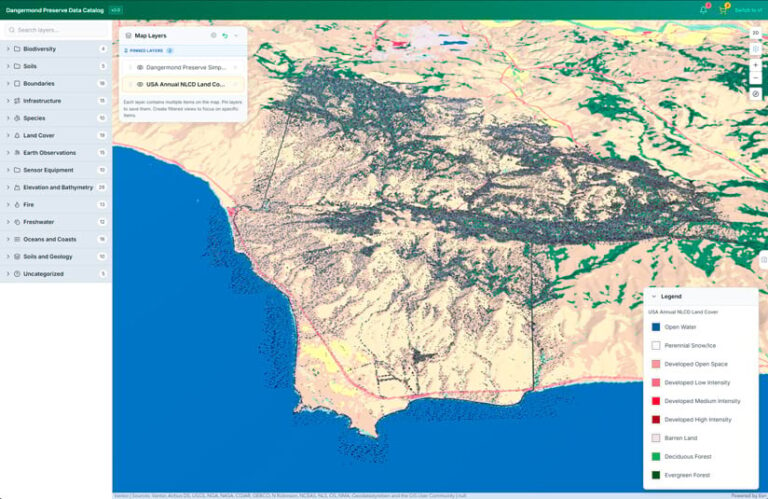
The Nature Conservancy’s (TNC) Point Conception Institute and the Center for Spatial Science at the University of California, Santa Barbara (UCSB), have partnered with Esri to create one of the first digital twins of nature at the Jack and Laura Dangermond Preserve—a 24,364-acre property owned and managed by TNC. The Dangermond Preserve, which sits at Point Conception, is one of the last remaining stretches of wild coast in Southern California. The Preserve’s unusual geography makes it a globally important site for conservation. Cold currents from the north Pacific Ocean collide with warmer water from the Santa Barbara Channel, creating uniquely diverse habitats for marine and terrestrial species.
In April 2026, the Point Conception Institute held a symposium—Science for a Wild Coast—that brought together 70 researchers and practitioners from TNC, the University of California, Vandenberg Space Force Base, California State Parks, and other institutions to take a deep dive into coastal research findings. The group previewed the Dangermond Preserve Research and Discovery Digital Twin, which gets real-time data on water, climate, and species from scientific instruments placed throughout the landscape. The digital twin is supported by diverse data and experiences, plus a geospatial hub.
Now, this digital twin—with nearly 1,000 GIS data layers representing everything from hydrology and soils to wildlife, roads, and infrastructure—is available for anyone to access. It connects more than 120 research projects at 50 partner institutions focused on species recovery and managing healthy landscapes, seascapes, and watersheds.
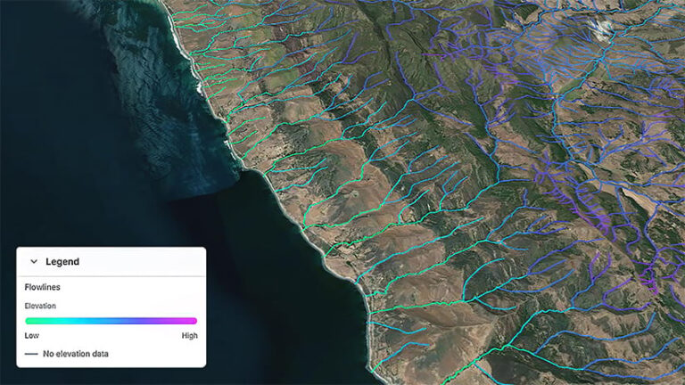
The vision for the Dangermond Preserve Research and Discovery Digital Twin is to create a virtual environmental system that functions like a research lab, enabling data-driven decision-making in conservation based on spatial and temporal patterns. Similar to how molecular scientists use microscopes to see the unseeable, a digital twin of nature magnifies spatial processes to show the hidden architecture of ecosystems.
At the core of the Dangermond Preserve Research and Discovery Digital Twin is an automated data pipeline architecture that ingests continuous streams from Internet of Things (IoT) sensors, wildlife cameras, and third-party scientific APIs such as eBird and the Global Biodiversity Information Facility (GBIF). These pipelines transform incoming data and route it to a cloud-based, PostGIS-enabled database for storage and preprocessing. From there, datasets are published as feature layers, imagery layers, and Open Geospatial Consortium services within an ArcGIS Enterprise deployment. The team chose ArcGIS Enterprise to leverage its robust support for direct connections to cloud storage. Once published, these layers become discoverable alongside items from TNC’s broader preserve operations through a shared catalog, creating a unified, queryable inventory of geospatial data for the preserve. This architecture is the backbone for the development of models and decision-making tools.
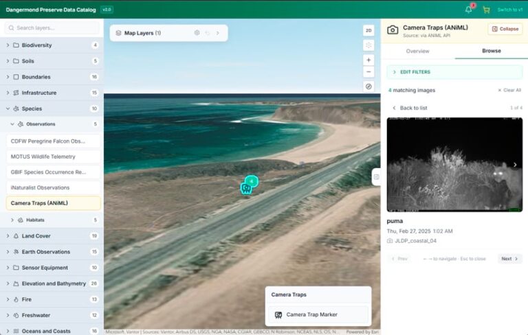
Current technology makes real-time data discoverable and shareable. Data that was previously difficult to map—like a network of cameras that collect images of wildlife along movement corridors—is now easy to visualize against a 3D backdrop of terrain data. When a camera captures an image, computer vision AI tools automatically identify the species—and the image, along with the observation date, is summarized and made accessible to users.
Users can search the archive to find and download all images of a particular species, or they can identify all species that have been spotted at a particular camera. For example, they can see a photograph of a mountain lion captured by a camera near the coast in February 2025, along with the date and time the image was taken. Users can query all other locations where mountain lions have been identified, or explore what other wildlife species have been observed at that location.
The Dangermond Preserve Research and Discovery Digital Twin is a living example of open science in action. By making data and GIS tools easily accessible, people around the world can participate in activities at the preserve. Anyone, anywhere can explore and use rich GIS data for interdisciplinary research or to teach topics ranging from wildlife conservation to hydrology to GIS.
The next phase of development for the digital twin will focus on running real-time analytics through ArcGIS Velocity and building dynamic visualization tools that allow users to highlight changes in spatial patterns over time. Analyses and visualizations will flag unexpected patterns in observed data, compare observed and modeled data, and assess various modeled outputs. The Dangermond Preserve Research and Discovery Digital Twin will also include a suite of tools for users to develop and run their own scientific models, allowing predictive solutions to be tested and deployed virtually before implementing them in the real world.
The Jack and Laura Dangermond Preserve’s wild coastline has supported a growing body of work on species recovery, translocations, and range shifts, highlighting the ecological implications of exploiting wildlife and coastal and marine resources. Now, paired with the Dangermond Preserve Research and Discovery Digital Twin, researchers and conservationists are prepared to accelerate the discovery and development of conservation solutions.
You are invited to join these efforts at the Jack and Laura Dangermond Preserve, with open access to the Dangermond Preserve Research and Discovery Digital Twin. GIS curriculum geared toward conservation is available to bolster use of the digital twin’s data via the UCSB Guide to the Geographic Approach.