Offering sunny blue skies, the periodic blizzard, freshly groomed slopes, and a chance for family bonding time, ski resorts across the United States attract skiers and snowboarders of all ages and abilities from late fall through early spring. Even in the midst of the COVID-19 pandemic, the 2020/21 winter season brought an estimated 10.5 million snow enthusiasts to US ski areas—making it the fifth-best year on record—according to the National Ski Areas Association.
When visiting a new ski resort or taking to the slopes with people of different skill levels, it can be difficult for everyone to find the right meeting spot, stay on trails that aren’t too technical, and navigate through a whiteout. But with Snow Mappy, a new mobile app from Esri startup partner Mappy, skiers and snowboarders can now use location intelligence to find their way around the mountain. The app also provides resort operators with anonymized user movement patterns so they can get a better idea of how visitors traverse the slopes and engage with resort services.

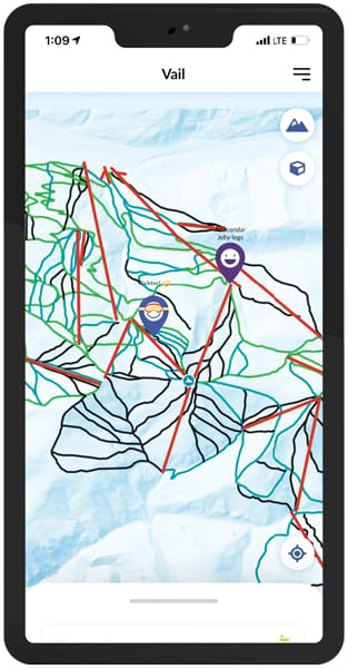
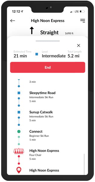
Snow Mappy has three primary functions: find, navigate, and interact. Users can search for amenities and locate their friends and family on interactive 2D and 3D maps. And the app, which is available for download on iOS and Android devices, provides network routing based on user-defined skill levels.
“Snow Mappy is perfect for anyone who needs to see where they are on the mountain when they are not near a trail sign, wants route planning ideas tailored to their level, and wants to meet up with friends or family at a specific location,” said Karyn Nolan, cofounder and CEO of Mappy.
The company, which Nolan founded in 2019, develops mobile apps and provides geospatial analytics to revolutionize the guest experience at ski resorts and other attractions. Snow Mappy is the company’s first app and was inspired by Nolan’s personal experience of trying to keep up with her skilled snowboarding husband.
“My husband is from Utah and is an expert skier and snowboarder. I grew up in California and am at an intermediate level, at best. Often, we would go to the top of the mountains, he would disappear down a run, and I would suddenly find myself confused, knowing I could inadvertently end up on a double-black diamond or the wrong part of the mountain,” she said. “I’ve been in the geospatial industry for 25 years, and as I was pulling out large, unwieldy paper maps, I thought, there has to be a better way!”
Bringing the Mappy Vision to Life
Nolan leveraged her experience in the geospatial industry to find experts to create the app. First, she needed to build the technical architecture leveraging ArcGIS software. This led her to attend a technical workshop for developers at the 2019 Esri User Conference (Esri UC). Given that Nolan was not a developer by trade, the instructor recommended that she attend the developer clinic hosted by Esri Services at the Esri UC Expo. There, Nolan connected with Josh Peterson, a developer consultant at Esri, for a face-to-face discussion about her ideas.
“I felt like this light bulb had gone off over my head when I was sitting with Josh, sharing my big idea. I wasn’t sure it was doable, and I was trying to figure out if I could afford to jump in with both feet. Josh gave me the confidence to give it a whirl,” Nolan recalled. “He outlined the specifics of how to develop the app in a way that felt doable, so it began to be more than just an idea.”
Nolan’s vision for the app was to modernize the winter sporting experience by blending the fun of skiing and snowboarding with geospatial technology in a platform that provides real-time navigation and connection. But for her, leveraging GIS technology in an app environment for consumer use was no easy feat.
“It’s very rare to find crossover between app developers and GIS,” said Nolan. “Esri’s technology is very powerful, but making sure that app developers are utilizing all the tools properly has been a challenge.”

To overcome these foundational obstacles, Nolan got connected with the Esri Startup program, which provided the Mappy team with discounted Esri products and account support. For a startup like Nolan’s, gaining access to technical experts who can help make key technology decisions and connecting with business partners that can augment the work is vital—and is often something startups lack. Peterson put Nolan in touch with Esri Services as well for GIS consulting and technical guidance.
“It isn’t a role most would think of Esri Services playing, but we do it all the time,” said Peterson.
“I was relieved to find out that Esri had professional services and that I could access expertise to help me with the overarching vision and the implementation,” said Nolan. “It was amazing.”
For a year and a half, developers collaborated to assemble the app’s technical architecture. To create 2D and 3D maps of the ski lifts and runs (rather than roads), the developers used ArcGIS Pro with ArcGIS Network Analyst. They built custom network datasets that equip the app with turn-by-turn navigation and real-time location sharing via mobile map packages, mobile scene packages, and ArcGIS Enterprise. They also employed ArcGIS Runtime SDKs to integrate the GIS data and capabilities with the native iOS and Android mobile apps.
Nolan hired FreshWorks Studio to build the user experience (UX) and manage the iOS app deployment. Esri partner GEO Jobe, which creates custom ArcGIS technology-based solutions, was brought in to assist with implementing the ArcGIS Runtime SDKs. GEO Jobe developers initially focused on fixing critical bugs within the app, such as the loading and rendering of 2D and 3D scenes, and then they stayed on to provide frontline support for launch day. Esri partner SpatialMax joined the team as well to help with Android development. Together, all these collaborators helped build Snow Mappy’s initial operating capabilities and ensured that it had sound architecture for future growth.
“Several aspects of this partnership have been rewarding—working directly with the Esri Services team, gaining exposure to the ski resort industry, and integrating with a startup organization,” said Eric Goforth, director of professional services at GEO Jobe. “Mappy intends to scale up rapidly…and we are happy to be part of the team that is enabling that growth.”
In addition to the consumer side of Snow Mappy, Nolan’s vision includes a business-to-business component that provides data analytics and visualization tools to ski resorts to help them improve services and support data-driven decision-making. Mappy leverages ArcGIS Velocity, a cloud-native add-on capability for ArcGIS Online, to provide real-time processing and analysis of anonymized user data captured during the ski season. This enables resort managers to determine guest movement patterns so they can improve operations. For example, Mappy and GEO Jobe employed big data analytics in Velocity to evaluate skier days (an industry metric that shows how many people visit a ski resort over time), guests’ spatiotemporal trends, and skier and snowboarder speeds in conjunction with datasets for on-mountain assets, such as ski lifts, runs, and snowmaking machines. The collected data is then made available on dashboards, built with ArcGIS Dashboards, for resort staff to visualize.

“It has been a long journey—a lot more than I anticipated,” Nolan reflected. “But I am grateful for the whole team, the Esri Startup program, and all the account managers who have guided me through the process.”
Navigating the Slopes Ahead
Snow Mappy on iOS launched in beta in February 2021 at five resorts in California, Colorado, Oregon, and Utah. Nearly 1,500 iOS users downloaded Snow Mappy, generating close to 7.5 million real-time skier data points. For the 2021/22 ski season, Mappy is supporting almost 20 resorts across the United States and Canada on both iOS and Android.
“People have been super excited about Snow Mappy,” said Nolan. “While we thought that the interactive map would be the biggest draw, users have told us they enjoy the 3D view of the slopes and being able to identify runs, lifts, and their location on the mountain. We have also had consistent feedback that the ability to find your family and friends is very helpful.”
Inspired by user testimonials, Nolan hopes to expand Snow Mappy’s functionalities to include itinerary planning, bragging rights, social feedback, and fitness tracking. Future goals include implementing indoor resort navigation using ArcGIS Indoors and enhancing the app’s UX with augmented reality (AR). Nolan also has plans to expand Mappy apps to markets such as relay racing, mountain biking, music festivals, and theme parks.
“Mappy mobile apps, map services, and data analytics can be easily rebranded and repurposed to a variety of markets,” said Nolan. “The interface and functionality stay basically the same, while the customized map services and design elements change.”
Nolan and her team are currently developing a companion app to Snow Mappy for hiking and biking that can be used at the same mountain resorts during the summer months. But one thing she is excited for in the near term is for GIS professionals to use the app.
“It is one thing to have the general public use the app, but it’s another to have GIS professionals and the community of Esri technology users to play around with it,” she said. “We hope they enjoy using it, and we are looking forward to receiving their feedback.”

