Web-Based App ArcGIS Excalibur Unites GIS and Imagery
Both geospatial analysis and imagery have evolved over the years. From the famous Lewis and Clark expedition of the western United States from 1804 to 1806 to the establishment of the National Imagery and Mapping Agency, now known as the National Geospatial-Intelligence Agency (NGA), in 1996, important projects and operations—at the international level down to the local level—have hinged on bringing together geospatial data, maps, charts, and imagery.
Although GIS and imagery have always had a symbiotic relationship, only recently have these technologies been combined in a single experience.

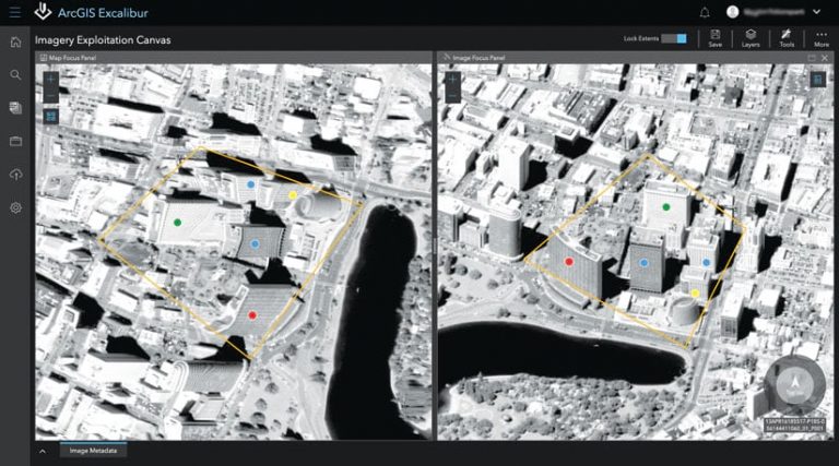
ArcGIS Excalibur transforms the way analysts search, discover, and work with imagery—all in a web app. Excalibur modernizes and enhances image-based workflows by unifying traditional, separate geospatial and imagery-based views into a single field of vision: the imagery exploitation canvas. This intuitive user experience has the power to improve daily decision-making across industries, from airlines that need to view flight patterns to farmers who need to monitor crop life cycles.
Regardless of what it’s used for, Excalibur provides a way to quickly access imagery, conduct efficient exploitation, and share results.
Greater Access to Imagery
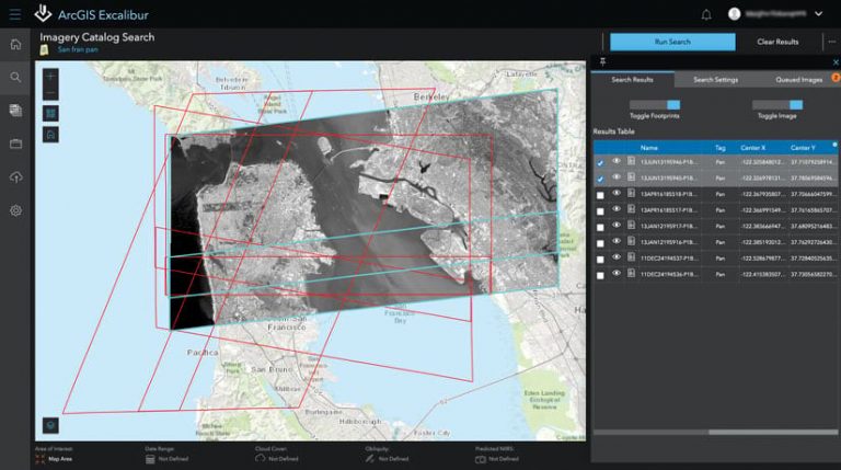
Excalibur has an integrated imagery search and discovery experience that provides one-click access to web-enabled image services and Web Map Services (WMS). Analysts can filter and refine images by date, cloud cover, predicted National Imagery Interpretability Rating Scale (NIIRS), obliquity, or name. The results of an image search can then be added to the queue for further analysis. Analysts also have the option to input a WMS URL for faster access to the imagery exploitation canvas.
Efficient Imagery Exploitation
With Excalibur, users can incorporate geospatial layers into their visual imagery analyses. This integrated approach allows analysts to extract observations or create markups from oblique imagery while maintaining their geospatial reference information.

In the imagery exploitation canvas, users can work with a focused image in its native perspective or in a split screen so they can also view it simultaneously in a map. Additionally, users can examine and employ tools that work directly with the imagery service they use. These tools include features that enhance imagery display, exploit imagery through markups and measurements, and export a user’s current view for use in presentations.
Excalibur also introduces what’s called an imagery project—a dynamic way for users to organize all the resources required for an image-based task in a single location. Projects can include imagery and geospatial reference layers, in addition to a set of tools that simplify image-based workflows. This can help analysts streamline structured observation management (SOM), imagery comparisons, and other imagery workflows.
Easily Share Results
Given that Excalibur is built to work right inside ArcGIS Enterprise, users can easily exploit imagery, export areas of interest, and share observations with stakeholders. For example, users can add their observations to feature services that others can access through web pages on any device. Users can also bring other ArcGIS apps and solutions into play to create products such as image observation reports, dashboards, interactive briefing materials, and dynamic analysis layers.
Get Started
To learn more about Excalibur and add it to your organization’s ArcGIS Enterprise deployment, get in touch with an Esri representative. Also, get the latest news about Excalibur.

