In industries that range from architecture, engineering, and construction (AEC) to transportation and government, digital twins are transforming how people make decisions based on data from the physical world. ArcGIS Reality, a suite of photogrammetry software products, enables users to create accurate digital renderings of objects and scenes at multiple scales and extents—from a single project site to whole cities and even countries.
With ArcGIS Reality, users can turn all types of aerial imagery from drones, crewed aircraft, and satellites into highly accurate maps and 3D models. The technology allows them to interact with a digital world that shows places and situations as they truly are, layered with geospatial data that enriches reality with greater context.
ArcGIS Reality includes the following four products:
- ArcGIS Reality Studio: This new, focused app for reality mapping helps users take aerial images and apply them to mapping entire cities and countries. Its interactive, mapcentric interface is built for large-scale production workflows and allows users to efficiently deliver survey-grade representations of reality.
- ArcGIS Reality for ArcGIS Pro: This new extension for ArcGIS Pro allows users to input images from drones or crewed aircraft into desktop GIS software to generate highly accurate 3D outputs for reality mapping.
- Site Scan for ArcGIS: Esri’s cloud-based, end-to-end reality mapping software for drone imagery simplifies drone program management and imagery data collection, processing, and analysis.
- ArcGIS Drone2Map: This is an intuitive desktop app that makes it easy for users to generate maps from drone imagery, thanks to its offline processing and in-the-field rapid mapping capabilities.
Read on to find out more about each product as well as how they work together within ArcGIS Reality.

ArcGIS Reality Studio
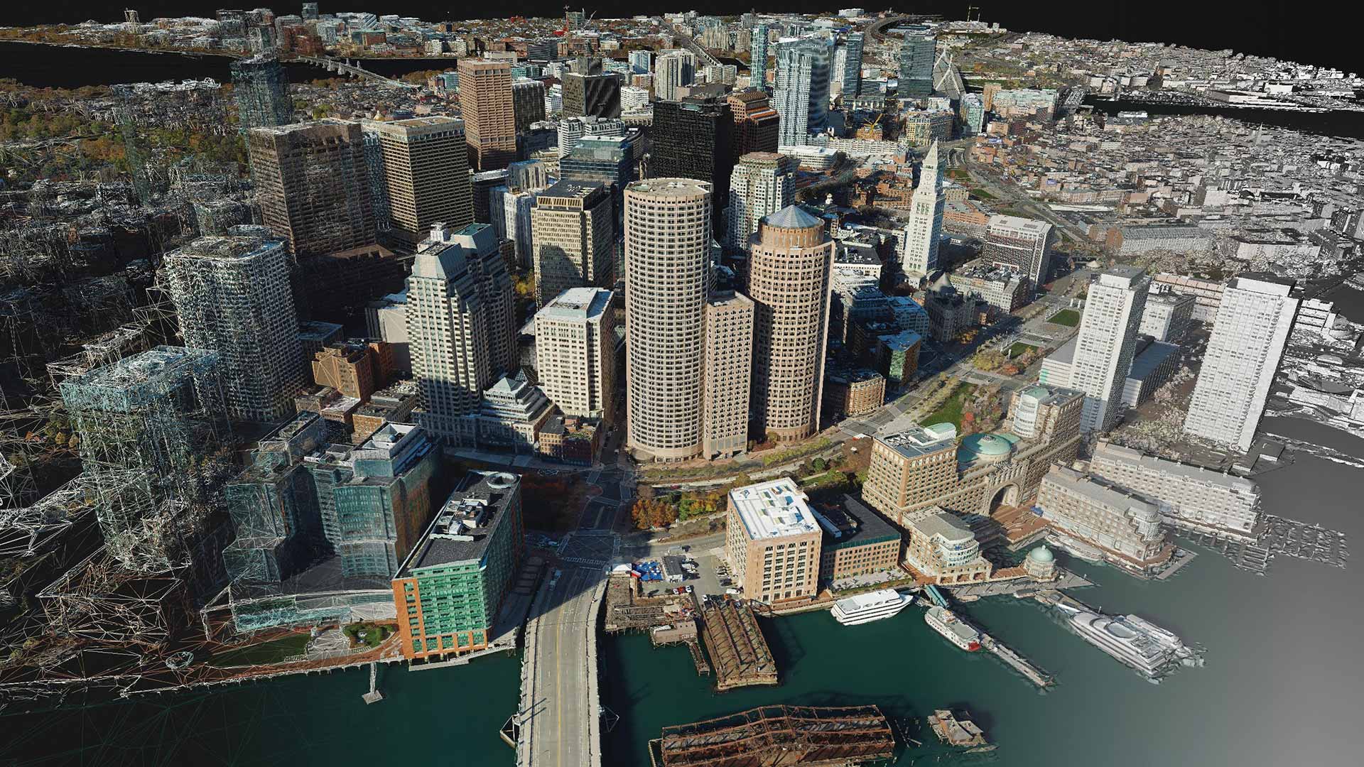
The need to build realistic representations of an area is not limited to individual sites and small regions of interest. It took years of research to design and build Reality Studio—software that’s optimized to use aerial imagery to map very large areas with precision, speed, and simplicity.
Reality Studio lets users apply reality mapping to regions of any size so that they can create the foundation for a 3D digital twin. The software provides automated processing workflows to help users quickly align large collections of images and efficiently create photo-realistic, survey-grade data products. Users can then bring this data into their GIS and mapping systems to perform advanced analysis and visualization.
The key capabilities and benefits of Reality Studio include the following:
- Data processing is fast. Users can process large or multiday data captures in a single project, rather than splitting them up across multiple projects.
- Content production is automated at scale. Users can employ automated workflows to create true orthos and 3D meshes—even for entire cities and countries.
- Results are accurate and photo-realistic. The workflows in Reality Studio automatically determine the optimal parameters—such as pixel size and quality—at each data processing stage, so the products that are generated are true to life.
- Customers see immediate value. Outputs created with Reality Studio can be used within the ArcGIS system or other, third-party mapping systems, enabling users to begin making informed decisions immediately.
ArcGIS Reality for ArcGIS Pro
GIS is rapidly expanding its uses far beyond traditional mapping, and the ability to integrate photo-realistic 3D representations directly in the mapping environment puts ArcGIS ahead of the curve.
Reality for ArcGIS Pro provides reality mapping tools that allow GIS professionals to create the foundation for digital twins and provide data for spatial analysis in ArcGIS. The extension allows users to use ArcGIS Pro to generate photo-realistic true orthos, point clouds, and 3D meshes from drone and aerial imagery. Processing and outputs are seamlessly integrated with ArcGIS, so they are quickly ready to use for analysis and visualization.
With Reality for ArcGIS Pro, users can do the following:
- Generate 3D outputs in-house. Reality for ArcGIS Pro delivers reality mapping capabilities in ArcGIS Pro, expanding what GIS users can produce to include true orthos and high-quality textured 3D meshes.
- Process drone and aerial imagery. Reality for ArcGIS Pro is camera agnostic and supports a wide range of drone and aerial sensors. This makes it flexible and able to grow with users as their hardware evolves.
- Integrate reality mapping content into analysis. Content that users create with Reality for ArcGIS Pro is immediately accessible in their ArcGIS spatial analysis workflows, so users can swiftly determine relationships, detect and quantify patterns, assess trends, and make predictions and decisions.
Site Scan for ArcGIS
As the use of drones for decision-making continues to expand, organizations need a solution that allows them to leverage drone-collected data whether their IT infrastructure is built on-premises or in the cloud. Site Scan for ArcGIS is Esri’s cloud-based reality mapping app for drones that enables geographically dispersed users to collect, process, and store large datasets regardless of local storage or compute capacity.
Now part of the ArcGIS Reality family, Site Scan helps users maintain their drone inventory and flight history, stay up-to-date with and securely process accurate imagery, and perform advanced analysis. The app leverages the same processing technology as the rest of the products in ArcGIS Reality, giving users a consistent way to create photo-realistic true orthos, point clouds, and 3D meshes.
ArcGIS Drone2Map
For organizations that use high-resolution drone imagery to make decisions quickly, especially in the field, this desktop reality mapping app enables users to process and analyze drone imagery without being connected to the internet. The accurate 2D and 3D representations of the real world that Drone2Map generates can be easily shared as well. Just like Site Scan, Drone2Map is now part of the ArcGIS Reality family and employs the same processing technology to allow users to consistently create photo-realistic true orthos, point clouds, and 3D meshes.