ArcGIS Urban is a web-based system designed to improve urban planning and decision-making. For planning commissioners and teams, local policymakers, city council members, and the public, it offers a comprehensive overview of development activities along with a suite of tools they can use to shape the urban development life cycles of their communities.

Regional and local regulations have consistently guided the growth and development of modern cities, but in the last 50 years, the connection between the rules that govern land use and the physical outcome has broken down. In many cases, this has resulted in urban sprawl that continues to grow, despite demand for mixed-use, walkable communities.
ArcGIS Urban represents an evolutionary step forward in how people interpret and better apply complex land-use regulations to make cities better by fostering a more livable urban form. With an immersive 3D experience, Urban gives organizations the capacity to visualize proposed transformations, enabling planners, local governments, and citizens to formulate a common understanding of what changes could take place in their communities.
A Complete Planning Support System
ArcGIS Urban, part of Esri Geospatial Cloud, consists of three components: a public-facing Urban Overview web app for standard browsers and/or mobile devices; a back-office Urban Design web app; and Esri CityEngine for desktop workstations.
Urban Overview allows users to search their cities and explore the locations of planned development, as well as their status. Allowing stakeholders to visualize citywide projects in a standard web browser supports the inclusive review of new projects and streamlines the building application process, potentially reducing it from months to weeks. A shared view of the development pipeline also increases public transparency, lessens uncertainty, and promotes greater community involvement in the review process.
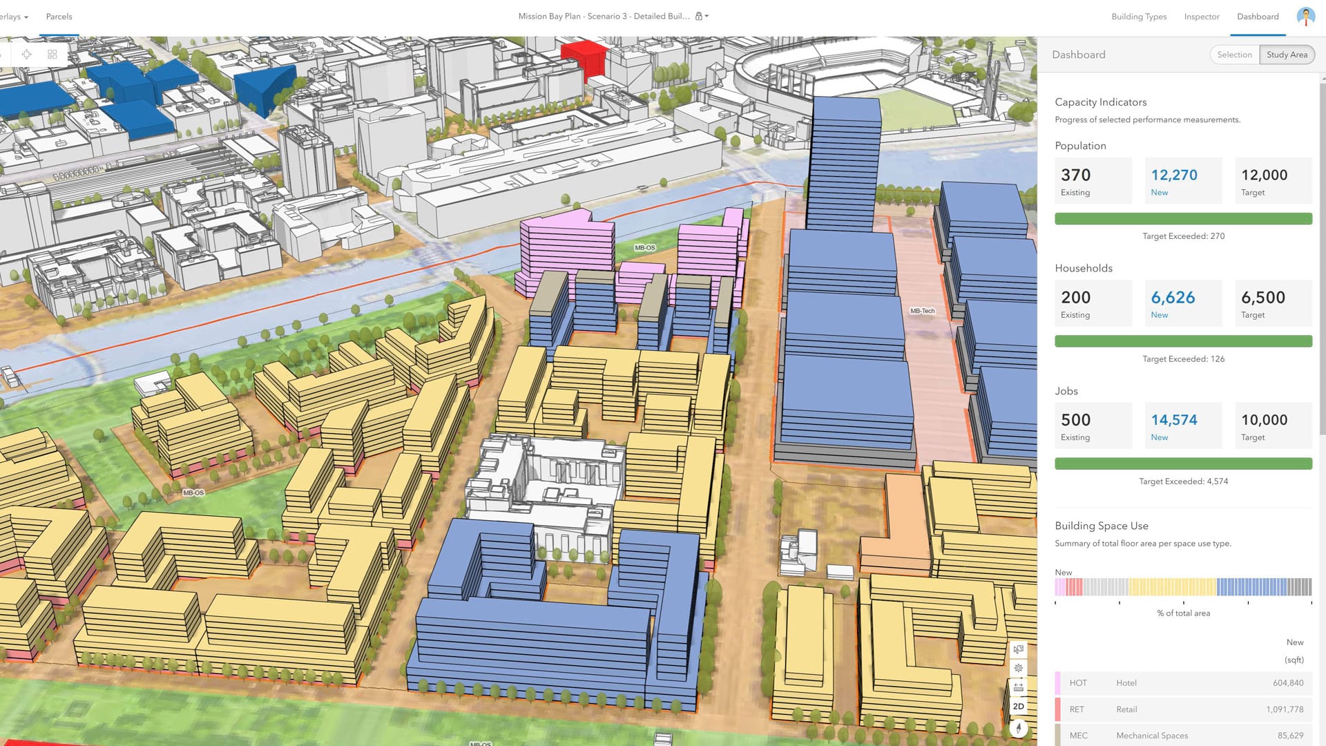
The Urban Design tools blend spatial information into a focused set of scenario planning capabilities. Starting with authoritative data on existing conditions provides the basis for future scenario development and reporting on key performance indicators, such as the number of new households and jobs. Users can author specific area plans that incorporate zoning considerations into the design process, which improves productivity and the viability of proposed development patterns.
CityEngine is now integrated with ArcGIS Urban as well. This enables users to access plans and projects directly in CityEngine by connecting to web GIS layers in Urban. Advanced downstream design workflows, such as detailed streetscape and façade modeling in CityEngine, can further leverage cross-platform interoperability with virtual reality (VR) platforms or other modeling software, including Unreal Engine or SketchUp.
With support for projects of varying sizes, Urban can strengthen collaborative planning efforts across teams and organizations. The system is designed to break through the technical barriers that often stand in the way of utilizing spatial information within rigorous scenario development.
Achieve Collaboration and Deliver Clarity
Local communities need to address the challenges that are related to affordable housing, walkability, and multimodal mobility, but they can’t do that holistically without examining the local zoning and land-use codes that encourage (or discourage) certain types of development. With ArcGIS Urban, users can get up and running with scenario development quickly, increasing their technical capacity to analyze the economic, social, environmental, and spatial impacts of plans and policies. Whether a community is undergoing a downtown revitalization or attempting to foster better transit-oriented development, Urban builds zoning considerations into the scenario-based process, ensuring the viability of conceptual plan development.
Urban also makes it possible to track progress by incorporating the active development pipeline, which comes in handy when creating plans for entire neighborhoods, since these often take years to implement and, thus, need to remain flexible and responsive to market forces. More importantly, since both planners and developers have a clear view of development guidelines, the review period required for building applications is reduced, and projects that align with the local community’s planning objectives are encouraged.

Each project in ArcGIS Urban can have a 3D model that portrays the shape and height of the major massing components of draft building proposals as they undergo revisions. Incorporating building information modeling (BIM) and other types of 3D information through the project submission process can improve spatial accuracy and certainty when evaluating the impacts related to shadow cast and viewshed. This gives planning teams a complete understanding of how proposed projects will affect the built environment and ensures consistency with land-use regulations.
In addition, users can take advantage of shareable web scenes and distributed collaboration in Urban, which can help build consensus across government, the real estate development community, and the public during the review process. This increases the opportunity to collaborate with local residents beyond the city council room, as all relevant stakeholders have a complete view of proposed projects.
Shaping the Future of Your Community
ArcGIS Urban is a new solution designed to respond to the significant challenges that cities face—from upsurges in population to the related development pressures. Planning can be a time-consuming and expensive process that is often reactive to changes in the local real estate market or the broader economy. But by following just three steps, professionals can leverage Urban to proactively increase resilience, expand transparency, and achieve equity in city planning.
First, users translate their local regulations—parameters such as building use, density, and dimensional requirements—into a system of record that they need for a modern zoning code. Many cities today are undergoing multiyear endeavors to rewrite their zoning codes and incorporate improved form-based urban design concepts. With Urban, users can assimilate this work into a framework to support scenario planning.
Second, users establish shared views of plans, projects, and indicators both internally across departments and with community stakeholders. A shared view of what’s being built and planned is necessary to make important decisions as a community, which can stimulate private investment and garner more support for long-term economic development goals.
Third, city officials can use Urban to reach elusive populations while also increasing transparency for residents who are unable to attend council meetings. This ameliorates the widespread urban development processes that are prevalent today, wherein developers present their projects to city councils and the council votes on them without much community involvement.
Urban makes it possible to create plans that foster the kind of human-scale communities the public wants while also promoting transparency in the development pipeline and offering new opportunities for public engagement. With a common operating view of plans, projects, and indicators, Urban empowers users to produce an attractive, sustainable, and equitable future for prosperous cities.