The Clean Water Act requires municipalities across the United States to implement programs that address water quality and prevent water pollution, especially in urban areas. That’s because dense residential and commercial development is dominated by impervious surfaces, which allow pollutants to flow unabated to waterways.
To protect water quality in urban areas, municipalities must install post-construction best management practices (BMPs). These are engineered structures—such as bioretention basins, vortex separators, filtration systems, and vegetated swales—that capture pollutants and prevent them from entering waterways.
In Carlsbad, California, to keep up with the maintenance needs of post-construction BMPs, the city developed a comprehensive, ArcGIS technology-based solution that streamlines data management and improves asset inspection processes. Most importantly, the system empowers the local community to help preserve Carlsbad’s water quality and protect the environment.
The Need for More Effective Data Management
Carlsbad is a unique coastal community located in north San Diego County. With more than 115,000 residents, the city encompasses 39 square miles and includes 7 miles of coastline, three lagoons, and four creeks situated in a hydrologic area that receives runoff from five nearby cities. When it comes to water quality protection, Carlsbad has earned a reputation as one of the most environmentally sustainable cities in San Diego County.

Effective data management is key to helping Carlsbad stay on top of its environmental responsibilities—especially when it comes to maintaining post-construction BMPs. Many BMPs are privately owned, so performing maintenance on them is a responsibility shared by the city and the community. The community agrees to keep its structures in good condition, while the city verifies proper maintenance and compliance by regularly inspecting the BMPs.
But the City of Carlsbad didn’t always have systems in place to make data management for post-construction BMPs easy. Under its old data management system, information was kept in different parts of the organization with no real way to integrate it or view data as a cohesive unit. Program management for post-construction BMPs was paper based, cumbersome, time-consuming, and costly. The city used six software systems and numerous workflows, which made it complicated to review engineered structures from hundreds of projects. Currently, the city provides oversight for 1,770 privately owned post-construction BMPs divided among 300 owners.
For over 25 years, the City of Carlsbad has leveraged ArcGIS technology—including ArcGIS Enterprise, ArcGIS Pro, and ArcGIS Online—as its system of record. GIS has been used to engage internal and external stakeholders and give staff members insight into the city’s infrastructure, utility management, land development, and many other data services. In 2020, Carlsbad’s GIS administrator—along with a public works business systems specialist, an engineering technician, and the city’s post-construction BMP program manager—began brainstorming for better ways to use GIS to manage the city’s BMP assets.
Without assistance from outside vendors or contractors, this small project team developed the Automation, Compliance, Tracking, Inspection and Owner Notification (ACTION) System, a comprehensive suite of apps and tools that organizes large datasets and synthesizes them into meaningful, reliable, and actionable information.
A Big-Picture Solution That Streamlines the Details
All members of the project team used their subject matter expertise and experience to develop the ACTION System. The GIS administrator and the business systems specialist modeled the database schema; wrote Python scripts; configured apps; and enabled reporting, analysis, and mapping capabilities. The engineering technician assisted with GIS integration and data entry processes. And the program manager led the project team to ensure that the ACTION System met the compliance and public engagement requirements of the municipal stormwater regulations.

ArcGIS technology serves as the backbone for Carlsbad’s ACTION System. It not only streamlines data management and smooths out the details—from conducting asset inspections to engaging with the community—but it also provides the city with a big-picture perspective of how well Carlsbad is complying with the Clean Water Act and other environmental initiatives.
For data modeling, the project team used ArcGIS Pro to develop the ACTION System’s database schema. The team started by modeling relationships among structures, inspections, responsible parties, and maintenance records by creating complex IDs for each BMP owner or operator. The GIS datasets were then filtered to identify and extract post-construction BMP assets, which provided the basis for the custom schema. Additional tables were created to manage inspection data and accept user inputs. These were then linked back to the assets through a series of database relationships. With all this in place, city staff can use ArcGIS Pro to create unique maps for post-construction BMP owners and operators that show each structure’s location, priority, and condition. The maps can be exported as PDFs and sent via email to each responsible party.
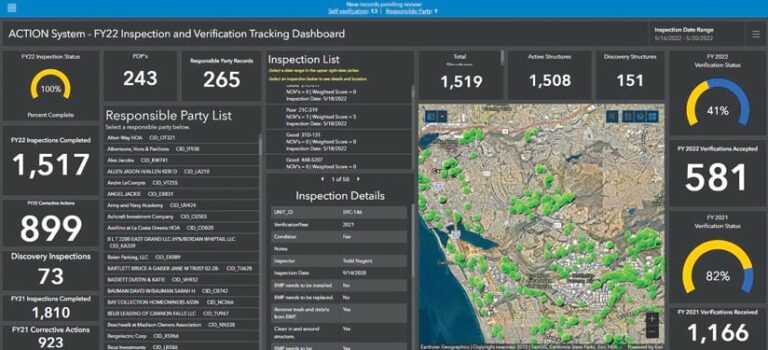
The city also provides responsible parties with links to their unique complex IDs, which connect to an app built with ArcGIS Dashboards and ArcGIS Survey123. The links take the responsible parties to personalized self-verification portals, where they can view interactive maps of their BMPs, document the condition of the structures, update contact information, and upload photos and maintenance records. When new data is ready for the city to review and approve, Carlsbad’s program manager receives a notification and can then leverage apps built with ArcGIS Experience Builder, Dashboards, and Survey123 to assess everything and quickly identify compliance issues.
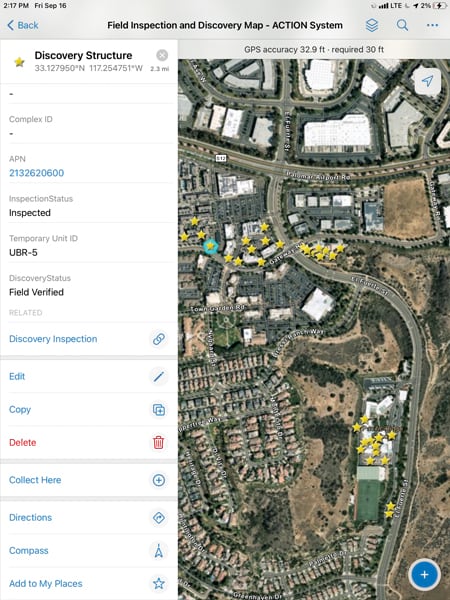
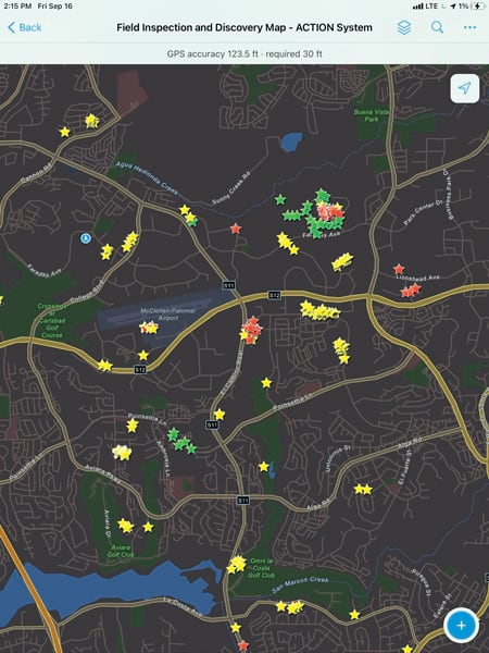
When the city carries out BMP inspections, the ACTION System employs spatial statistics and cluster analysis to find hot spots of potential concern. This indicates where staff members should focus their resources and outreach initiatives. And when inspectors go out to assess the condition of post-construction BMPs, they now use ArcGIS Field Maps to capture photos and fill in easy-to-use forms. The app also allows them to work offline when necessary and sync their data to the system later.
During inspections, the program manager uses interactive dashboards to monitor progress and gain an overall view of program compliance. The program manager also manages data without assistance from the city’s GIS department, thanks to an app built with ArcGIS Web AppBuilder that makes it easy to review, edit, and validate data from a desktop computer.

One of the most important parts of the ACTION System is sharing information with the public, which fosters transparency, increases engagement, creates a sense of community ownership over BMPs, and goes a long way toward changing people’s behavior. This is now done through an ArcGIS StoryMaps story called the “City of Carlsbad’s TCBMP Program.” The visually engaging narrative encourages the community—especially owners and operators of post-construction BMPs—to actively participate in protecting the quality of Carlsbad’s water.
Returns on Investment Run the Gamut
The City of Carlsbad’s innovative ACTION System is a completely digital, GIS-based asset management platform that was designed and implemented entirely by leveraging existing staff and technological resources. The system allows city staff members to visualize Carlsbad’s post-construction BMPs as an integrated network while measuring program effectiveness.
Since its launch in 2021, the ACTION System has produced numerous returns on investment, including the following:
- Post-construction BMP program costs have been reduced by 44 percent.
- Program staff have cut down the time it takes to manage BMPs by 40 percent.
- Because owners and operators can now submit BMP maintenance verification records via the ACTION System, it now takes them 75 percent less time to submit maintenance verifications, and there’s been a 24 percent increase in submittals.
- Field staff have decreased the amount of time it takes to inspect BMPs by 34 percent.
- The program has reduced paper use by 73 percent, resulting in an overall program cost savings of 57 percent.
Additionally, the city saved an estimated $100,000–$350,000 by creating its own system that employed already-existing technology rather than hiring contractors or outside vendors to do the work.
Key Ways to Shift Program Strategies
Post-construction BMPs are valuable because they help increase awareness about water quality issues and inspire municipalities to partner with the public to prevent pollution from reaching waterways. By improving how the City of Carlsbad encourages BMP compliance, the ACTION System has generated a measurable shift in the processes, norms, and relationships that are critical to managing these important environmental assets.
When municipalities shift their program strategies to see environmental asset management as a community resource and regard public engagement as a catalyst for change, they can implement policies that better leverage technology, encourage collaboration, and foster sustainability. Municipal governments can no longer just provide public services. They now need offer sound solutions, progressive policies, and professional expertise to make sustainable environmental asset management realistic and attainable.


