Home to more than 1.5 million people, Córdoba is Argentina’s second-most populous city. The centrally located capital city stretches 222 square miles across the center of Córdoba province and is connected by a complex bus network. It’s an economic and cultural hub, with the National University of Córdoba—the country’s oldest university—attracting students from around the world.
For decades, city staff have used GIS to monitor and improve infrastructure, public safety and health, planning, and engineering. Córdoba’s local government is divided into 16 decentralized community participation centers so that the needs of residents in individual regions can be prioritized.

Recently, city staff implemented a variety of geospatial tools including ArcGIS Dashboards, ArcGIS Survey123, ArcGIS Experience Builder, ArcGIS Web AppBuilder, ArcGIS Hub, and ArcGIS StoryMaps to enhance the government’s territory management strategy and help Córdoba become a smart city. These tools modernize operations, balance the natural and built environments, fuel equitable and inclusive policies, promote sustainable development, and allow city agencies to more easily engage with the public.
Opting for the Cloud
For Córdoba, being a smart city isn’t just about collecting geographic data—the goal was to improve the lives of residents and the places where they live, work, study, and play. Mayor Martín Llaryora requested an effective way for each government office to gather, visualize, and analyze data, which would help senior management make data-driven decisions.
Before establishing this strategy, it was often difficult to understand and use city data in meaningful ways. “People would produce reports with printed out pages of a spreadsheet,” said Víctor Di Rienzo, Córdoba systems and connectivity undersecretary. “I saw one report that had 35 columns and more than 500,000 rows of data. This made it very difficult to sort through data for analysis and decision-making.”

The first step in the process was to migrate georeferenced data to ArcGIS Enterprise, creating a comprehensive geodatabase that employees could maintain, update, and validate. This data is used to improve transportation routes, identify new economic centers, launch enhanced and accessible health services, plan for future roads and services, and accomplish other evidence-based initiatives. Because city agencies must respond to issues across the region, it’s important that data is centrally located and easily accessible by all departments, regardless of their location. A cloud-based GIS makes information accessible to city staff, external partners, and the general public.
From inspections to repairs, information is collected with ArcGIS Survey123 and synced to the cloud. According to Córdoba data and statistical analysis director Andrés Michel, training and implementation were swift; in less than a week, teams were able to use the tool. It was important that staff members who weren’t familiar with GIS could use it.
Di Rienzo said teaching staff members to use Survey123 is an easy way to convey fundamental GIS concepts to beginners. “We found that once we provided training; set up initial workflows; and explained how to upload, manage, and format the data, it didn’t take long for a user to learn the basics and some of the more advanced features of ArcGIS,” he said. “It opened their eyes to data visualization and decision-making like never before.”
Sharing Information
Using ArcGIS Hub, the city launched a smart community portal to share collected information with partners and the public. Users can access planning and survey data or explore cultural and environmental information. The portal is a collaboration tool for city agencies, external partners, and residents. For example, residents can interact with data about the city forest plan by species or neighborhood. Users can learn which trees they can plant based on their location or how a certain species is dispersed in an area.
“We’re using GIS data to provide context for the information,” said Michel. “With a little bit of work, you can readily perform spatial analyses with your tabular data and show it in the context of a map of the urban passenger transport system.”
-
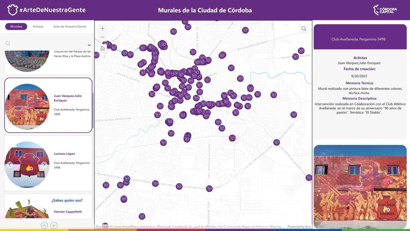
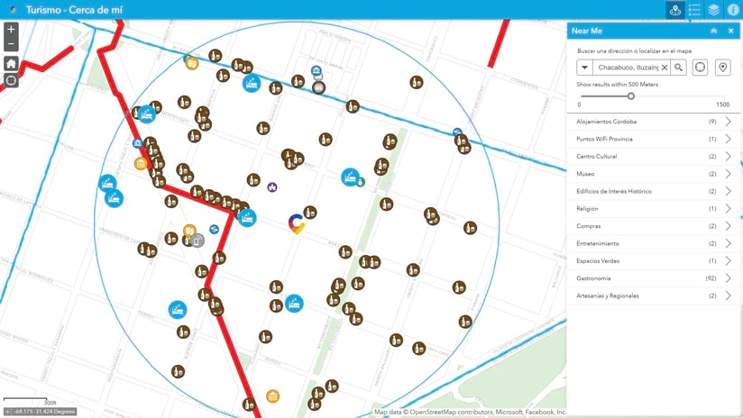
The maps that city staff have developed include ones that show the locations of urban art in Córdoba and places of interest for tourists.
Combining geographic information in one accessible system allows for other integration opportunities. Cadastral data—plots, addresses, and streets—is standardized so that neighborhoods are defined in accordance with cadastral standards and are georeferenced transparently. This information can then be displayed and analyzed in one view with ArcGIS Dashboards, making it easier for city leaders to make decisions.
A Plan for the Future
Córdoba’s objective is to enhance the lives of its residents. As a smart community in today’s evolving landscape, this requires a comprehensive long-term strategy that places residents at the core of its plans. Whether assessing the impacts of ongoing developments or reevaluating zoning regulations, environmental considerations, and infrastructure, it is crucial to incorporate reliable data, analysis, and mechanisms that facilitate transparent communication with the public.
Geospatial tools improve Córdoba’s territory management strategy by revealing patterns in transportation, land use, density, and more. These insights ensure that all populations are duly considered and adequately served while equipping decision-makers with the information they need to plan for the future.
Prioritizing individuals and geographic location as guiding principles for planning projects makes the pursuit of smart initiatives worthwhile. By implementing the right tools and processes, Córdoba is revolutionizing its operations and enhancing the well-being of its residents at the same time.