When organizations need to tell important geospatial stories, standardize disjointed processes, or implement extensive new systems, Esri partners have the expertise and tools to make those jobs easier. Find out how Esri partners Datastory, Arup, and UDC contributed geospatial solutions to help rehabilitate a struggling downtown; bring along the electric vehicle revolution; and modernize two utilities’ geospatial infrastructures, laying the groundwork for other utilities to follow suit.
Telling the Compelling Story of a Historic City with Modern Promise
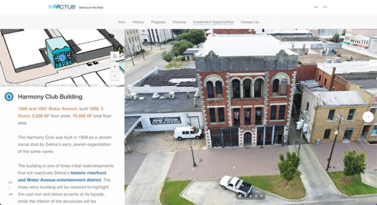
In 2019, InVictus Development—a development firm that builds affordable, multifamily housing and rehabilitates historic commercial properties—completed 56 affordable housing units in northern Selma, Alabama. Throughout the development process, InVictus cofounders Paula Rhodes and Rick Cavalieri visited the city frequently, and while they knew Selma as a city of profound historical significance, they were surprised by its untapped potential. Many of downtown Selma’s iconic structures—with scenic views of the Alabama River and the Civil Rights Movement landmark the Edmund Pettus Bridge—were buckling due to years of neglect.

In collaboration with members of the Selma community who were pioneering redevelopment, Rhodes and Cavalieri further invested in Selma’s future by purchasing and optioning several downtown buildings. Their vision was to renovate the buildings in a way that reflects their historical significance while modernizing them to attract retail and residential customers to the downtown district. Because traditional investment metrics would not favor investing in Selma, the challenge InVictus faced was how to tell potential investors a compelling experiential story about Selma that was grounded in data-driven evidence.
InVictus turned to Datastory to help highlight the history, progress, promise, and opportunities available in Selma for real estate investors and current and future residents. Working with stakeholders, the team at Datastory leveraged ArcGIS StoryMaps to shine a light on what makes Selma forward-thinking and unique and invite viewers to learn about specific opportunities to invest in and engage with the community. The resultant ArcGIS StoryMaps narrative, which leverages an array of data from Esri and public government sources, is filled with stunning data visualizations. Creative analytic outputs include measurements of tourism that are derived from human movement data compiled by another Esri partner, SafeGraph, and a visualization of people’s live-work patterns gleaned from US Census Bureau data.
The powerful presentation encourages people to connect with InVictus and join the community of Selma to help lead it into the future.
Improving Site Selection Methods for EV Charging Stations
One of the key barriers to achieving widespread electric vehicle (EV) adoption in the United States is that there is no nationwide network of charging stations. To scale up EV infrastructure quickly and cost-effectively, special attention needs to be paid to where curbside public charging stations are built.

Currently, many site selection methods are ad hoc and done on a case-by-case basis. To give decision-makers access to consistent site selection methods, pertinent geospatial data needs to be available in a centralized, online location.
Taking on this challenge, global built environment consulting firm Arup collaborated with Los Angeles Cleantech Incubator (LACI) and three leading energy utility companies to assess the curbside EV charging infrastructure landscape in Southern California. From these findings, Arup developed a geospatial site suitability platform called Charge4All that offers a unique approach to assessing the suitability of potential EV charging station sites.
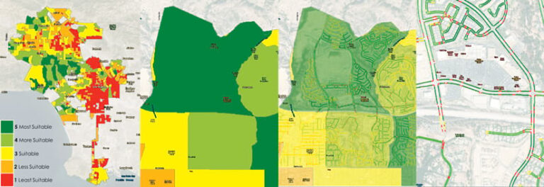
Charge4All leverages ArcGIS Pro, ModelBuilder, ArcPy, and ArcGIS Online and features color-coded maps that display a breadth of geospatial data—including needs in dense areas with multiunit dwellings—to determine locations that are suitable to host EV charging stations. By zooming in on GIS-developed smart maps, decision-makers can see details down to the curb to determine a potential site’s proximity to existing electrical infrastructure and different types of roads.
The goal of Charge4All is to help elected officials, utilities, and community leaders choose the most effective and equitable locations in which to install EV charging stations. The level of detail available on the platform, which can include street-level views, enables users to prioritize certain sites before conducting in-person inspections, saving organizations time and money.
After launching Charge4All in Southern California, Arup is now partnering with officials in other cities across the United States to help them explore how to expand EV charging infrastructure within their communities.
Standardizing Gas Utilities on a Common GIS
Energy company AVANGRID, which operates in 24 US states, has two primary lines of business: Avangrid Renewables and Avangrid Networks. Avangrid Networks is composed of eight electric and gas companies in the northeastern United States. Until recently, two of these companies—Southern Connecticut Gas (SCG) and the Berkshire Gas Company (BGC)—were not using GIS to spatially manage their assets and networks.

To better align SCG and BGC with their cosubsidiaries, AVANGRID chose UDC to help transition them to GIS from computer-aided design (CAD) mapping systems and lay the foundation for implementing ArcGIS Utility Network. One of AVANGRID’s goals for the project was to define a common GIS Utility and Pipeline Data Model so that it could eventually use that to standardize all Avangrid Networks gas companies.
Focusing on data conversion and app development, UDC worked with SCG and BGC to leverage their existing geospatial technology investments—including ArcGIS technology and ArcFM software from Esri partner Schneider Electric—to create a complete distribution-level GIS with spatial locations for gas utility assets. Schneider Electric provided product support for its Session Manager extension (which allows users to run through approval processes prior to posting to a geodatabase), consulted on tracing features, assisted with setting up the environments, and helped create workflows.
While implementing the utilities’ GIS infrastructure, UDC also digitized and converted their gas data, mapped legacy data sources in Utility Network, and developed integrations and web and mobile apps. These simultaneous efforts enabled SCG and BGC to continue with normal business operations while seamlessly transitioning to a comprehensive GIS.
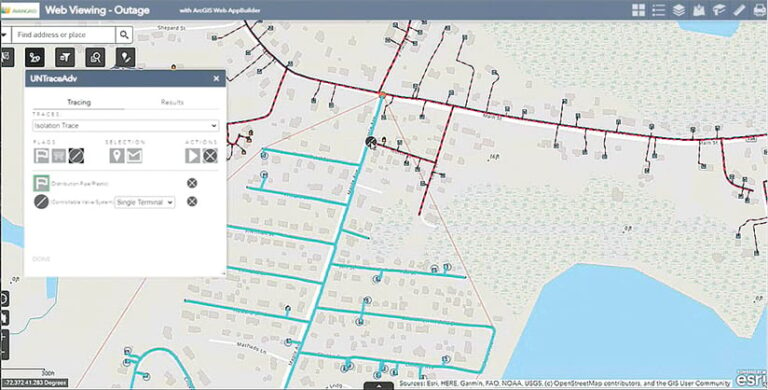
SCG went live with its GIS production environment in September, and BGC is scheduled to follow soon. The two utilities will now use GIS to support gas operations, emergency planning, outage management, asset replacements, new business expansion, and more. Traces implemented using the new network management system will aid with leak surveys, outage management, and network analysis within the companies’ Synergi Gas engineering software from Esri partner DNV. Because of the configured network traces, staff members at both utilities can more effectively manage risks and outages without having to build as many models or conduct a lot of analyses.
The initial implementation of Utility Network at SCG and BGC is intended to be the template for all other Avangrid Networks subsidiaries as the product is rolled out across the enterprise. UDC is assisting Avangrid Networks in training users on the new web and mobile apps, ArcFM, ArcGIS Pro, and specialized add-ins that enhance utility workflows.
“This implementation is important to AVANGRID because it lays the foundation for our future,” said George Porto, IT GIS applications manager at AVANGRID. “It was a unique opportunity for us to learn about [ArcGIS Utility Network], and we are confident that it will help us be successful when we migrate our other electric and gas companies in the not-too-distant future.”

