The value of being able to read is immense. Literacy affects how far people make it in school, which jobs they get, how much money they make, whether or not they tend to vote, how well their children can read, and much more. And that’s not to mention its role in improving comprehension, developing the imagination, and learning new things.
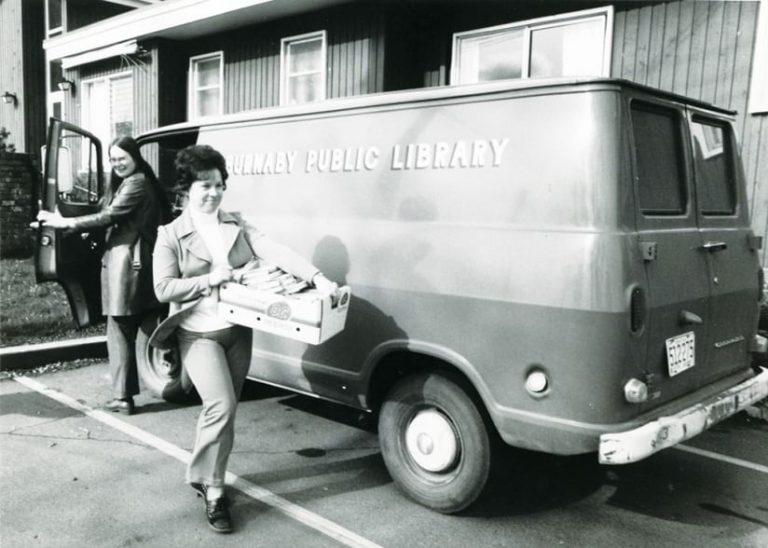
These are just some of the reasons the City of Burnaby—the local government for the third-largest city in British Columbia, Canada—has a decades-old program that delivers library services to Burnaby residents who are unable to visit the library themselves. The Home Library and Accessible Service (HLAS) Department, a branch of the Burnaby Public Library, delivers library materials to patrons who are challenged by health, mobility, or transportation issues or other obstacles that make visiting the library infeasible.

Hundreds of patrons use the service. Challenged to deliver so many books, the HLAS team partnered with the City of Burnaby’s GIS division to improve the route planning and delivery processes. Using ArcGIS Navigator, the GIS division was able to help the HLAS team automate daily route planning. Ultimately, this has enabled HLAS staff members to better serve their patrons.
“ArcGIS Navigator is helping the Home Library and Accessible Service team meet [its] goals of providing an efficient delivery service to the community,” said Simone Behrens, a mapping technician 2 for the City of Burnaby.
The Value of GIS for Home Deliveries
Library materials are delivered to patrons four days a week by two HLAS employees. The schedule is based on a four-week rotation beginning on Tuesday and ending on Friday. For the two employees, each day involves somewhere from 10 to 25 stops in the city.
Previously, to plan routes, the HLAS team used its database to search the addresses of the delivery stops and then manually created routes for the following day’s deliveries. The process was time-consuming and inefficient, taking time away from packing, preparing, and making the deliveries.
Having attended the Esri Canada User Conference in Vancouver, Canada, several years ago, Jorge Cardenas, acting branch manager for the Burnaby Public Library, discovered the value of GIS and believed it could benefit the HLAS program. He contacted the City of Burnaby’s GIS division to have it help implement GIS technical support to modernize HLAS’s routing workflow and mapping approach. Cardenas wanted a new solution that could help automate route mapping to streamline day-to-day operations.
This was somewhat new territory for the GIS division. “We had never worked with the library before,” said Chad Huntington, manager of GIS and engineering systems for the City of Burnaby. “I want to emphasize the fact that we had a GIS champion in Jorge, who saw how [GIS] would be helpful for HLAS.”
A Manual Process Moves to an Automated System
Behrens was tasked with streamlining HLAS’s existing workflow. At the time, she was a practicum student at the British Columbia Institute of Technology. Huntington suggested that she try ArcGIS Navigator because the GIS team had not previously worked with it, and he wanted to gain some familiarity with the app.

Each week, HLAS staff members update their proprietary database with patron data. The GIS team employed extract, transform, and load (ETL) tools to automatically push this data to the city’s ArcGIS Enterprise environment. Once the data was housed there, Navigator, which uses GIS to route field personnel and create customized travel routes, integrated seamlessly with the city’s existing systems. This made implementation straightforward, according to Huntington.
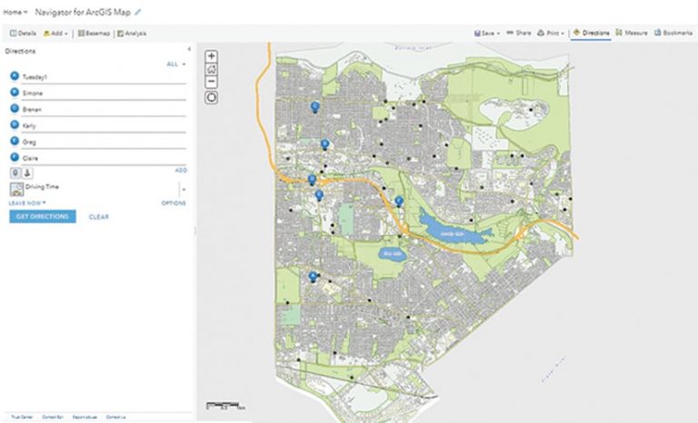
Using ArcGIS Enterprise, Behrens created four different web maps for every week of the month. Each week contains individual delivery days that reflect the actual deliveries that need to be made. From these web maps, HLAS staff members can select the rotation week and specific day they’re assigned to and click the Route to All button to create a customized delivery route. The route is then automatically available on an iPad with Navigator installed.
When creating routes, users have the option of manually ordering stops or choosing the fastest route. For example, if they know a certain patron has to receive deliveries in the morning, they can rearrange the order to accommodate that. Otherwise, if there are no special considerations, they can pick the fastest route.
Training HLAS staff was fairly simple, according to Behrens. Based on notes and processes she used when developing the new automated system, Behrens created two manuals for HLAS staff members to learn how to use Navigator: one with step-by-step instructions for how to create routes and use the app, and one with standard operating procedure workflows.
Behrens said that despite the learning curve and having staff switch from a manual process to an automated service, Navigator has been well received. Three regular HLAS employees use the app, as do several auxiliary workers who help with driving.
“The drivers themselves are happy with it. They’ve learned how to use this new technology in their day-to-day practices,” said Behrens. “It’s really been beneficial to show them the benefits of GIS, and they can expand off of it in the future.”
Better Serving Staff and Patrons
Since its implementation, Navigator has streamlined planning and route creation for the city library. Route planning used to involve HLAS staff posting a paper map on the wall, putting pins in the map to mark delivery addresses, and finding the best route from there. Huntington said that going from this manual system to automatically creating a route in a matter of seconds has enabled the team to assist the community more effectively.
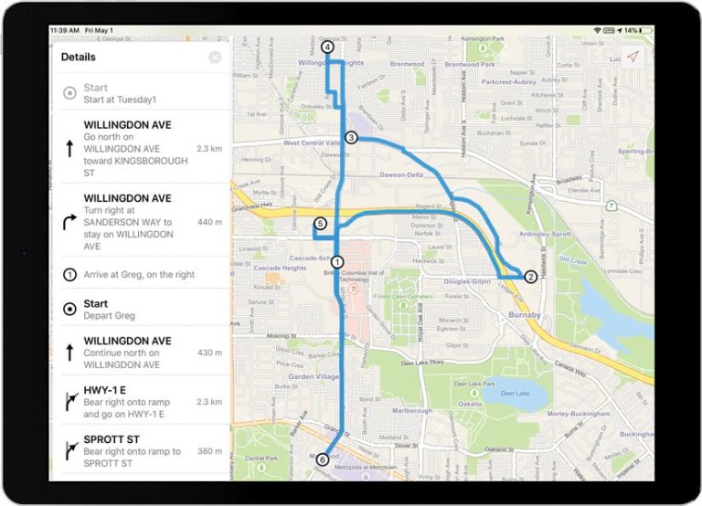
“This is the first opportunity we’ve had to provide an application that can provide turn-by-turn directions in an automated fashion,” said Huntington. “I think this is really useful for them just to be able to open up their app, click on the day and where they’re delivering to, and have all the information there already.”
The route automation is also helpful for auxiliary staff who may be unfamiliar with the HLAS system or the delivery area. Behrens said that because it’s much easier to obtain routes, automation increases their comfort level and helps them be more efficient.

During route planning, Navigator also has several features that help drivers stay safe when they go out on the roads, including the ability to avoid various obstacles. For example, ongoing construction in Burnaby used to make it difficult for staff to navigate and reroute their paths. Now, Navigator automatically creates a new route when the original path is deviated from, allowing drivers to better navigate construction and other road impediments.
HLAS always staffs two people in each van—one driver and one passenger. With Navigator available on mobile devices and tablets, the passenger can use an iPad to look at the route and dictate directions or relay the voice navigation, allowing the driver to focus on the road.
“The key advantage of the new Navigator system is that delivery no longer requires years of experience of driving around Burnaby,” said Damian Trasler, home library and accessible services clerk for the City of Burnaby. “I’ve been working for HLAS for almost three years, but I still have trouble remembering the best routes for deliveries. It’s nice to be able to pass the responsibility on to the iPad rather than the passenger.”
Another beneficial feature of the new system is that it delivers important details on patrons, which also helps improve the delivery process. HLAS staff can click on any point on the web map and see all the attributes associated with each patron, such as their reading likes or dislikes and telephone number. All details are kept confidential in ArcGIS Enterprise while allowing easy access to the information in the field via the iPad.
“The information is visible right away, and everyone’s information is available with the click of a button,” said Behrens.
Huntington said the initial goal of creating a new system was to have something that’s self-serve for the library, due to the limited availability of support staff.
“We’re unable to provide a daily or a weekly support system to them, so the new system [with Navigator] is very user-friendly,” he said. “Somebody who’s unfamiliar with GIS can go into it, log in, create routes, and then deploy them to drivers.
“If [staff members are] spending less time trying to figure out where to go and navigate through the city and more time…either getting recommended books for the customer or spending time with them at their homes, they’re better able to build relationships,” said Huntington. “If they have an extra five minutes to spend with the customer to chat with them and help them with their daily lives, then that’s something that we’re happy to be a part of.”

