Established on the first official Earth Day on April 22, 1970, the New Jersey Department of Environmental Protection (NJDEP) advances strategies to safeguard and enhance New Jersey’s air, water, land, and public health. A longtime Esri customer, NJDEP has used Esri’s GIS software for decades to support its mission. NJDEP is also a member of the Esri Advantage Program, which provides GIS guidance and collaboration.
The Bureau of GIS, a part of NJDEP’s Division of Information Technology, traces its origins to the 1980s. In those days, a handful of staff members used ARC/INFO for research, analysis, and planning, such as for finding the proximity of known contaminants to a stream or an elementary school. By the late 1990s, GIS use at the bureau had expanded and its importance as an analytical tool was recognized.
Since its inception, the bureau has educated NJDEP staff about the value of GIS in data and application development and system administration. What was once an obscure tool used by a few scientists is now a mission-critical enterprise system. Today, NJDEP has almost 3,000 employees, most of whom create or use ArcGIS maps and apps for their work. According to Angela Witcher, manager of the Bureau of GIS, “I’m a 30-plus-year veteran of GIS. I’ve seen it evolve in many ways and I feel like its impact is now escalating very quickly.”
GIS Training Takes Many Forms
The evolution and rising impact of GIS at NJDEP are largely due to training, said Witcher, who was once a GIS trainer. “As the use of GIS grew over the years, training was facilitating that growth and more users required more training, so it all grew together,” she said.
Leveraging Esri’s Advantage Program, NJDEP deploys ArcGIS Pro, ArcGIS Online, ArcGIS Enterprise, ArcGIS Experience Builder, and ArcGIS apps to support data collection, visualization, research, analysis, and public outreach initiatives.
The bureau is responsible for creating and delivering training to ArcGIS users throughout the department. GIS specialist Jessica Bagtas, who joined NJDEP in 2019, served as the bureau’s training coordinator until leaving the department last fall. (Bagtas, now a senior GIS course developer and education specialist at Esri, was interviewed for this article while still at NJDEP.)
“Training comes in a lot of different forms at NJDEP,” Bagtas said. “We have our formal, in-house training. We have courses about how to create web maps and apps and how to use ArcGIS Pro. We also have a GIS help desk that’s available both to NJDEP employees and to the public. For any type of GIS question out there, we’re available to answer it.”
Governance is also a priority for the bureau. “We’re teaching staff how GIS works at NJDEP, why they should create an application a certain way, how it will interface with the rest of the enterprise, and things like that,” Bagtas said. “We’re trying to make sure that folks make software and services that meet all the standards that we have at NJDEP. It’s not just GIS education, it’s almost like NJDEP education.”
If anyone misses an in-house training, or if they’re interested in a topic that isn’t covered, they’re directed to Esri Academy, Witcher said.
“Occasionally, we offer Esri instructor-led courses and have an Esri instructor come to campus. For advanced and specialized workflows, we use Esri training,” Witcher said. Recent Esri instructor-led classes provided training on ArcGIS Pro and ArcGIS StoryMaps. Attendees included staff from other NJDEP offices.
A bureau website also provides information on training, data, applications, and standards. On a separate NJDEP open data website, people can find and download the bureau’s GIS data to use in their own maps and applications. The bureau also provides an online bureau gallery with dozens of web apps, ArcGIS StoryMaps stories, and dashboards.
Supporting Key Applications
Providing public access to NJDEP’s trove of environmental data and GIS information products empowers people, Bagtas said, adding that although most applications can be mastered quickly, some require basic GIS knowledge.
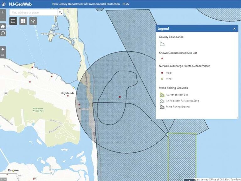
An NJDEP-built web application called NJ-GeoWeb is important to many users, Bagtas said, adding that NJDEP has trained staff and stakeholders on this application for years. It’s a screening application that allows visitors to see commonly used layers, such as parcel data, municipal boundaries, and locations of known contaminated sites.

NJ-GeoWeb users include people who want to submit a permit or learn more about environmental protection and real estate professionals who want to see factors for potential real estate buyers or sellers to consider. Many people use the application, so NJDEP provides virtual training at least twice a year, Bagtas said. The application includes links to training resources such as a quick-start tutorial, a user guide, frequently asked questions, and YouTube videos that show how to complete common tasks such as interacting with the map and searching for addresses and parcels.
Going Public with Educational Outreach
In addition to supporting staff and stakeholders with training resources, the bureau participates in educational initiatives that inform state residents about environmental issues and NJDEP programs. The bureau also connects with traditionally underserved groups.
“Education and outreach is an aspect of NJDEP, so it’s part of our mission to support these programs as well,” Witcher said. “Environmental justice and overburdened communities are formally defined in New Jersey. Permit applications for things like smokestacks and waste discharge include consideration of impact on communities.”
In summer 2022, NJDEP hosted young people from overburdened New Jersey communities in a program that introduced them to all aspects of the agency, including environmental protection careers. NJDEP leadership wanted program participants to be aware of GIS as a career path, so the bureau’s work was included in this initiative.
In one session, participants went to a state park, where they opened an ArcGIS Survey123 form and then took pictures of features such as benches and recycling bins. “At the end of the day, we showed them a map with all the pop-ups and pictures they had put in. I met with them formally and explained what GIS is, connecting the dots between their field activity and the map,” Bagtas said.
Witcher stressed the importance of teaching GIS in an accessible way, noting that in 2023, bureau staff supported a public outreach event in Camden, New Jersey. “We went to meet students in the field to do data collection,” she said. “We did field mapping using a smartphone, because that’s technology they know.”
Continuing Success with Service
The GIS footprint at NJDEP is still growing, as it has since the 1980s.
“Looking at the evolution of the program,” Witcher said, “we’ve gotten so big. Everyone’s bought into GIS. We now have programs that have their own GIS leads, and they support their users locally in a more formal way.”
Living up to its name, the Bureau of GIS will continue to lead the way in supporting NJDEP’s GIS community, Witcher said.
“You have to have a strong customer service component in your GIS program if you want it to be successful,” she said. “You do really exciting things when people are empowered throughout the agency. You have to have that customer service element.”

