Ethics has long been a topic of concern in the geospatial community. Since the earliest development of technologies that permitted remote and closeup surveillance, geographers have been concerned about the limits—or, more accurately, lack thereof—of what is possible with geospatial data collection.
Interest in geoethics has increased dramatically in recent years with the rise of social media and personal devices that serve up abundant user data, as well as the greater capacity of open mapping and voluntary data collection. Building on previous efforts over the past two decades, the American Geographical Society currently has its EthicalGEO project; the American Association of Geographers (AAG) and Open Geospatial Consortium, Inc. (OGC), have organized online meetings to discuss ethics; and the United Nations Global Geospatial Information Management group is focusing on teaching geospatial ethics.
Such interest may reflect a response to the growing power of geospatial technology and its potential for intrusion, surveillance, and misuse. This interest has been especially prominent during the COVID-19 pandemic, which has shown, more conspicuously than ever before, the potential of geospatial technology to trace individuals and their contacts. Perhaps the increased engagement with geoethics also reflects the consequences of the rapid research that had to be done to track the spread of COVID-19—consequences that may have included cutting security and privacy corners to produce helpful results.
This year, the AAG, in collaboration with Esri and the Center for Spatial Studies at the University of California, Santa Barbara (UCSB), began a multiyear conversation about ethical issues associated with location information and geospatial technologies. Currently, the project is taking the form of a webinar series. The first of these, on ethical spatial analytics, occurred on February 9. More gatherings are planned in the next few months with the intent of holding an international summit in late 2021 or early 2022.

The series seeks to bring together geospatial professionals from all sectors—academics, industry, and nongovernmental organizations—to create an action plan for directing greater attention to the ethical issues facing those of us who practice geography and GIS. The organizing committee, which I cochair along with AAG executive director Gary Langham, has been working for the past half year to put this programming together. Led by AAG director of geographic research Coline Dony, committee members include Mei-Po Kwan of the Chinese University of Hong Kong, Jeremy Crampton of Newcastle University in the United Kingdom, Katina Michael of Arizona State University (ASU), Richard Appelbaum and Krzysztof Janowicz of UCSB, and William Herbert of Hunter College of the City University of New York.
Geoethics is a vast topic. Some of the ethical issues we face are common to all professions, although the expression of these issues is distinctly spatial. Diversity, equity, and inclusion are especially important, as many events from 2020 demonstrated, such as COVID-19’s inequitable impacts in terms of race and income and the highlighted police violence that is part of larger, ongoing patterns in the United States. Other ethical issues arise more or less uniquely in the activities of geospatial professionals. The project has chosen to focus the majority of its efforts on these.
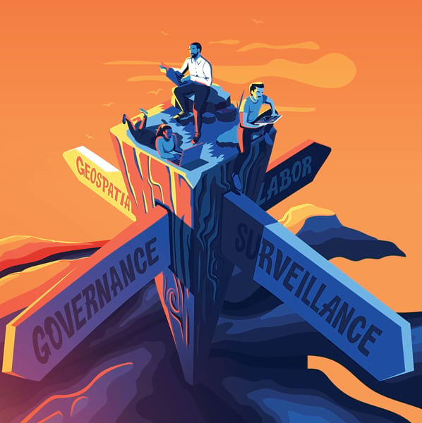
Organizers of the geoethics series developed four topic areas to address both the overarching issues and the specifically geographic concerns. These will form the initial emphasis of our conversation, although we fully expect to modify and augment the following topics as other matters are identified:
- Surveillance: The availability of technologies that do surveillance—tracking individuals, recognizing faces in closed-circuit television (CCTV) videos, building profiles of individuals based on their spatial behavior, and compiling information on people’s social contacts—raises many ethical issues. What can be done to protect individuals’ privacy while preserving individuals’ freedom?
- Labor and employment: Surveillance is increasingly used in the workplace, much of it with a geospatial dimension. How can workers be protected? What regulations are needed? What are best practices in this area? And how should employers deal fairly with employees?
- Governance: What are alternative models for the ethical regulation of geospatial technologies? What ethical issues are raised by open data and software, data ownership, and the presence of both private and public agencies in the geospatial industry?
- Geospatial analytics: Analyzing geospatial data, as well as formulating predictions and drawing inferences from it, raises important ethical issues. Some of these are well known, such as the ecological fallacy and the effects of modifying areal units. New issues are coming to light with the growth of geospatial artificial intelligence (GeoAI), the ability to replicate and generalize inferences from geospatial analytics, and the ease with which anonymized data can be reidentified.
In its earliest stages in late 2019 and early 2020, this geoethics project was supposed to have launched at an in-person meeting in Santa Barbara. But the arrival of COVID-19 postponed that, and the webinar program was introduced to build interest and momentum.
The first webinar in February was organized jointly with ASU as its 2021 Spatial Analysis Research Center (SPARC) workshop. It attracted more than 250 registrants. Peter Kedron and Amy Frazier of ASU moderated the webinar, and five speakers introduced four major topics on ethical spatial analytics:
- Mia Bennett from the University of Hong Kong and Luis Alvarez León from Dartmouth College discussed the ethical implications and property regimes of remote sensing, along with the importance of ethnography as a human-oriented source of ground truth.
- Peter Rogerson from the University at Buffalo presented ethical paradoxes that arise when attempting to make decisions based on inferences informed by doing spatial statistical analysis on sociodemographic data.
- Renee Sieber from McGill University discussed the ethical implications of GeoAI and locational big data, touching on the use of doorbell video cameras, biases in facial recognition technology, the internal workings of machine learning systems, and the ethical responsibilities the investigator has in using these tools.
- Jacqueline Vadjunec from Oklahoma State University focused on the ethical dimensions of spatial analyses based on data generated during citizen science projects, the ongoing need for mixed methods research, and the implications of both for reproducibility.
Video recordings of these presentations and the subsequent discussion are available.
It has become abundantly clear from these and previous efforts that ethical issues emerge throughout geospatial practice. In my own teaching, I have addressed many of these under the rubric of critical spatial thinking—that is, the thought processes that experienced users of geospatial technologies go through. For example, what do I know about the origins and quality of this dataset, and what does it not tell me about real conditions on the ground? The data seems to support a particular inference, but what other inferences might also explain the data? What can I do to ensure that the results of this analysis are used appropriately and in the best interests of the public? Our students must be encouraged to think beyond the immediate operations of the GIS interface and about each project’s broader ethical issues—and then carry those concerns with them into their careers.
Additional webinars in the series will be announced when details become available, so please check the website for updates. The organizing committee is hoping that the long-delayed face-to-face meeting will be possible in December.
We welcome any comments about and expressions of interest in the project, the webinars, the in-person meeting, and other activities. Please contact me (good@geog.ucsb.edu), Coline Dony (cdony@aag.org), or any other member of the organizing committee.


