
GIS professionals have always looked for new ways to understand the world through data. In GIS, that data often manifests as points, lines, polygons, and the attributes associated with them. But some of the most valuable information organizations collect isn’t stored in neatly structured attribute tables. It’s found in photographs, inspection reports, maintenance logs, survey responses, and other forms that can be difficult to analyze at scale.
A photograph attached to a feature might reveal a damaged asset. An inspection narrative might describe multiple conditions requiring attention. A field report might contain valuable observations that never make their way into searchable GIS attributes.
The information is already there. The challenge is unlocking it.
Artificial intelligence is making that challenge easier. By bringing AI-powered image and text analysis into ArcGIS workflows, organizations can turn photographs, reports, and observations into structured geographic information that can be mapped, analyzed, and acted on. A photo collected during an inspection could be automatically summarized. A resident’s service request could be categorized and standardized. Thousands of narrative reports could be transformed into consistent, searchable information ready for mapping and analysis.
This is where AI moves beyond productivity enhancement into something more transformative. It allows organizations to convert previously inaccessible information into geographic insight.
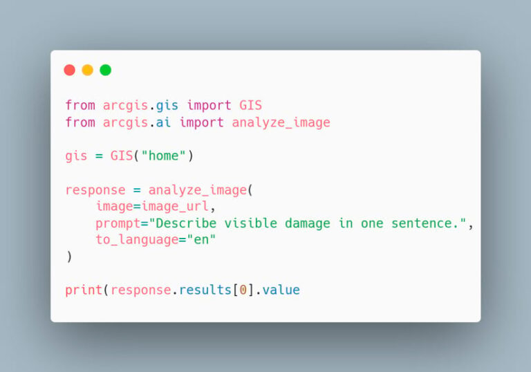
One powerful new AI tool that does this is the arcgis.ai module in ArcGIS API for Python. The module allows ArcGIS users to extract information from photographs, summarize reports, classify narrative content, and transform unstructured information into GIS-ready data with natural language prompts.
To help ArcGIS users explore this capability, the Esri Geo Experience Center (GeoXC) developed the AI Analysis Toolbox, a downloadable ArcGIS Pro toolbox that brings AI-powered image and text analysis directly into ArcGIS Pro. With this toolbox, users can select a layer, provide a prompt, and write AI-generated results back into their data. It can be used within ArcGIS Pro, while the included Python code can be explored, adapted, and extended for new workflows.
Note that while this capability is in beta, ArcGIS Online credits won’t be charged. After general release, running this tool will consume credits.
Extract Meaning from Images
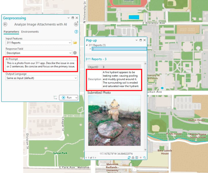
The toolbox includes tools for analyzing photos stored as feature attachments or those referenced by URLs or file paths. Simply select the features to process, specify a destination field, and provide a natural language prompt describing what information you want extracted. The tool then analyzes each image and writes the results back into the dataset.
You might prompt the AI to do any of the following:
- Describe observable damage
- Identify maintenance issues
- Read text from a sign
- Extract asset numbers
- Classify photographs into categories
- Identify visible safety concerns
Rather than simply storing images as an attachment for a human to review, the tool generates a concise description of the observed condition and stores it as an attribute that can be searched, filtered, summarized, and analyzed.
The same workflow supports a wide range of applications. A utility company can examine pole inspection photos. Emergency managers can document storm damage. Parks departments can evaluate trail conditions. Environmental organizations can classify wildlife camera imagery. Photos that once served only as supporting documentation can become analytical inputs. Images become another source of geographic information.
Rather than creating a specialized tool for every scenario, organizations can adapt the analysis to the question they are trying to answer.
Make Text Mappable
But images are only part of the story. Many GIS datasets contain large volumes of narrative text in the form of inspection reports, incident descriptions, maintenance records, survey responses, and public feedback. While this information contains important context, it can be challenging to identify patterns across thousands of records.
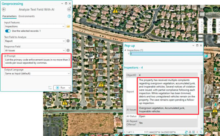
AI-powered text analysis brings structure to this content. By supplying a prompt and a text field, analysts can generate summaries, extract key issues, categorize records, or identify recurring themes.
For example, a lengthy code-enforcement report describing overgrown vegetation, accumulated debris, and inoperable vehicles can be transformed into a concise list of issues to be filtered, grouped, and visualized geographically.
When narratives become structured information, they are easier to analyze. Patterns emerge that might otherwise remain hidden in paragraphs of text.
The Future of Geographic Analysis
GIS is changing the way we work with information. As AI becomes more deeply integrated into ArcGIS, information that has traditionally lived on the sidelines—in photographs, documents, reports, and notes—becomes part of everyday geographic analysis.
The arcgis.ai module and the AI Analysis Toolbox offer an early look at that future, helping organizations transform more of the information they already collect into actionable geographic insight.
The future of GIS isn’t just about collecting more data. It is about uncovering new insights from the information we already have.