In a country where nearly 90 percent of residents live or work in cities, thoughtful urban planning is crucial to community health and well-being. That’s why the Department of Transportation and Planning (DTP) in Victoria, Australia, has turned to location intelligence to enable smarter decision-making in its transportation, land development, and policy planning.
DTP has leveraged the Esri technology stack—including ArcGIS Maps SDK for JavaScript, ArcGIS Pro, and ArcGIS Enterprise—to drive innovation in its use of spatial technology. Additionally, the department has employed an array of capabilities, from data-driven visualization to 3D client-side analytics, to develop custom web apps that have enabled staff to streamline processes and reduce manual work, significantly improving the organization’s overall efficiency.
Doing Great Work with Spatial Technology
DTP’s spatial services team consists of experts from diverse backgrounds, including urban planning, cartography, and spatial analysis.
“The members of my team share one thing: a passion to do great work with the spatial technologies we have available,” said Justin Madex, a spatial services manager who leads a team of software engineers at DTP.
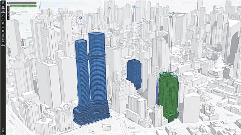
Spatial analysis plays a pivotal role in many of DTP’s key projects. It helps staff calculate new buildings’ potential to cast shadows on existing infrastructure; guide the development of affordable housing across the state; and design what are called 20-minute neighborhoods, where essential services are no more than a 20-minute walk away.
“Spatial technologies are empowering planning for Victoria’s future,” said Madex.
His team provides many forms of spatial services and support to the planning group. For example, team members are responsible for collaborating with local councils across Victoria and ensuring the accuracy and consistency of the spatial dataset associated with the state’s planning scheme—a legal document that details the policies and provisions for land use and development. Victoria’s planning scheme includes 44 planning zones and 27 overlays. The dataset is extensive.
“Victoria is only half the size of California, but we have to work closely with all 79 counties across the [state] as they submit updates or amendments to the department,” said Madex. “And since not all councils use spatial technology at the same level, amendments can be submitted a lot of different ways.”
Until 2018, this meant that DTP had a group of staff members dedicated to processing these amendments and continually managing the planning scheme dataset.
“Since then, we’ve invested significant time in improving our operations,” said Madex. “It started with the introduction of the Esri technology stack.”
DTP integrated Python scripts, built add-ons to ArcGIS Pro, and implemented topology rules across the datasets with the goal of streamlining the process and reducing the amount of manual work that had to be done.
“We now spend far less time managing the dataset, thereby improving the team’s overall productivity,” said Madex.
Modern Apps Support Comprehensive Urban Planning
DTP has taken significant steps as well to enhance its development of web mapping apps to support urban planning. In-depth market research and a successful proof of concept revealed that ArcGIS Maps SDK for JavaScript was the best fit for the department’s needs. The team’s decision was further solidified by the SDK’s road map for development, detailed documentation, extensive sample library, and strong user community—all of which aligned well with DTP’s objectives.
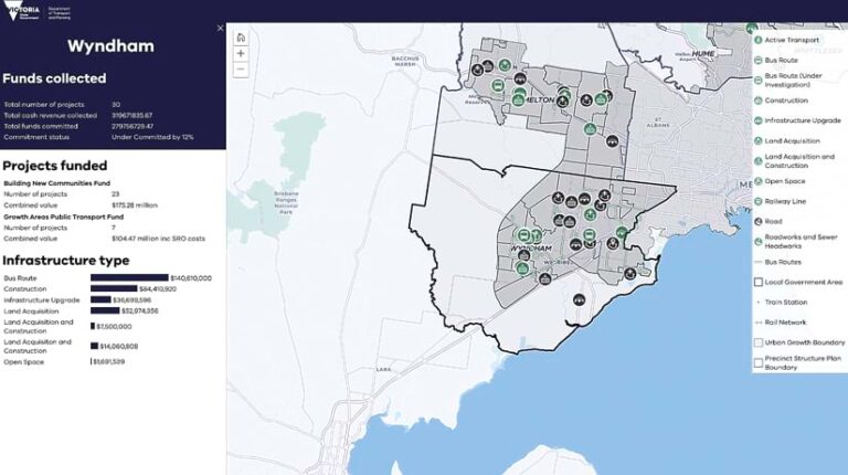
“Interactive mapping applications are one of the most powerful tools we have for depicting complex scenarios and modeling,” Madex said. “Applications built using the JavaScript Maps SDK are empowering us to put the spatial in the hands of our users who are traditionally nonspatial.”
Using JavaScript Maps SDK, the department has produced modern custom web mapping apps that are user-friendly and highly functional. The apps are designed to handle large volumes of data and allow users to seamlessly integrate and visualize spatial information in real time. The various data layers that the apps support—including zoning, demographic, and environmental information—are all essential for comprehensive urban planning.
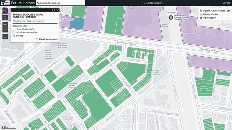
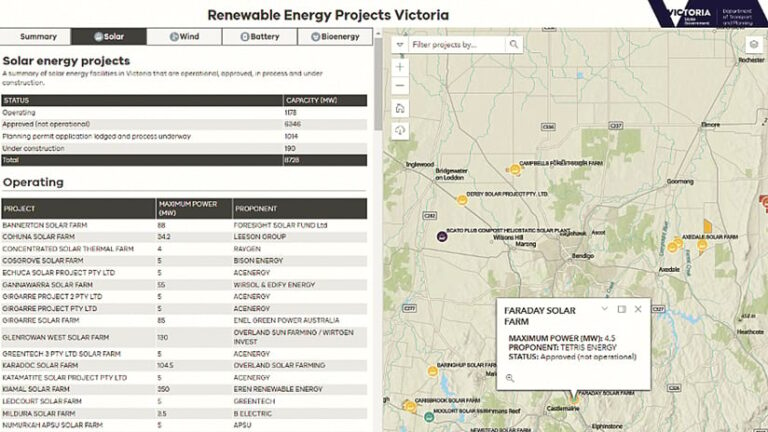
For example, the team used JavaScript Maps SDK to create an intuitive web mapping app for the Victorian government’s Future Homes program, which offers a streamlined planning pathway to develop three-story apartment buildings. The app simplifies the process of determining eligibility for the program. The team also developed a web mapping app that helps modernize the approval process for new renewable energy projects. It allows planners to review and manage the progress of their permit applications and, ultimately, provides a view of renewable energy projects across the state of Victoria.
These and other apps are crucial for engaging with the community. They provide a transparent platform for stakeholders to view and interact with planning proposals. And their interactive nature enables users to simulate different planning scenarios that show potential outcomes and facilitate more informed decision-making.
A 3D App Provides Vivid Visualizations
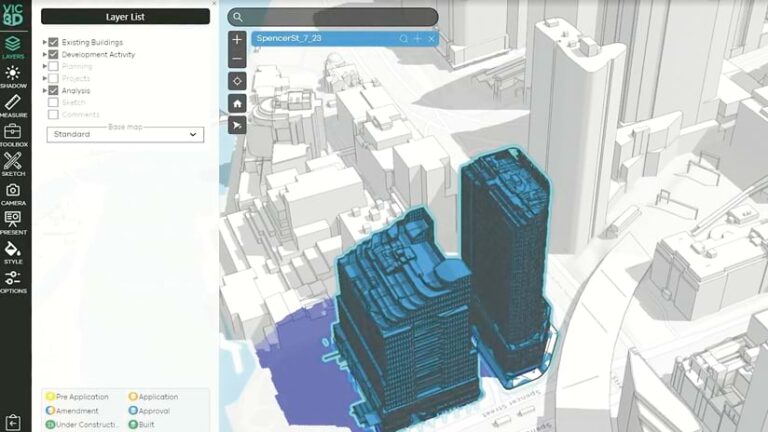
One of the most innovative apps that DTP has developed is Vic3D, an app that provides 3D and augmented reality (AR)-based visualizations of Victoria’s urban landscapes. In the sophisticated arena of urban development, this app ensures that the state’s distinctive landscapes are deeply integrated into the planning process.
Vic3D, developed with JavaScript Maps SDK and supported by ArcGIS Enterprise, leverages several key capabilities of the software development kit (SDK), including the ability to import textured and untextured realistic photo meshes; employ 2D datasets; perform viewshed analyses to calculate a new development’s potential to overshadow existing built forms; and assess shadow accumulation using out-of-the-box widgets.
The app empowers planners to analyze diverse 3D datasets, such as those related to building models and topographic maps. These are crucial for evaluating—without technical assistance—the impacts of proposed developments on a city’s cherished vistas and heritage sites.
Vic3D can also help stakeholders review planning permit models alongside existing structures, offering clear and tangible perspectives on new developments. This is vital for projects that might affect key landscapes and historical sites, since all new structures must harmonize with Victoria’s stunning natural environment and vibrant city scenery. Moreover, the app integrates AR to give users an immersive experience that brings proposed changes to life.
This innovative approach to viewing possible future developments enhances public consultations and enriches the decision-making process, allowing stakeholders to get vivid visualizations of potential impacts.
Enhancing Sustainability and Livability
By strategically employing Esri technology to its existing workflows and processes, DTP exemplifies a forward-thinking approach to urban planning.
“Leveraging the web mapping technology available across the ArcGIS technology stack has not only enabled us to provide powerful decision-making spatial data to our users in an intuitive manner, but it has also uplifted the overall spatial intelligence of the department,” Madex said. “More than ever, we have people across the department coming to us asking to leverage the platform for new and exciting projects.”
DTP’s innovative and adaptive use of spatial technologies has enhanced collaboration, efficiency, and accuracy across its planning processes, as well as enriched the quality of life of Victoria’s residents.
