Spring Creek Outdoors, LLC, is a 15-year-old wildlife and habitat consulting company based in Texas. Its offerings include conducting wildlife population assessments, making harvest recommendations, hosting seminars, and doing appraisals, but its true focus is on education. When the company first began employing ArcGIS technology in 2017, for instance, it used the software to create visualizations that helped teach landowners and land managers how to better understand their properties, as well as how to provide the support their lands needed to thrive.
For many of its clients, Spring Creek Outdoors revolutionized how they got their properties inspected. This used to entail hiring a helicopter to perform in-person aerial assessments, but the cost and logistics of that were out of reach for many property owners. So the company came up with an effective solution: GIS-enhanced aerial drone imagery. This worked well for clients and even made aerial surveys a possibility for a wider range of landowners. But eventually, Spring Creek Outdoors wanted to learn more about how to apply location intelligence to the challenges landowners face.
“Shortly after we began using GIS in our business, we attended a short course on GIS for ranchers and had our eyes opened to the range of ways ArcGIS could be used beyond providing an overview of a property,” said Cathy Ledbetter, vice president at Spring Creek Outdoors. “We came back to the office and went right to work on finding ways to enhance our services by using GIS software.”
The company wanted to make the aerial survey data more versatile and useful for its clients. So Ledbetter and her team set out to find a user-friendly way to access maps in the field and annotate them on the spot with quick sketches and notes. Esri partner Bluefield GIS —a 2020 graduate of the Esri Startup Program—had the answer.
Seamlessly Annotating Maps On-Site
Bluefield GIS was founded in 2017 in Charlotte, North Carolina, with the goal of developing innovative, easy-to-use mobile mapping apps for GIS users. Its Draw Maps for ArcGIS is a mobile mapping app that allows users to employ virtual colored pencils, pens, and highlighters to make sketches and notes right on a map using a tablet or mobile phone.

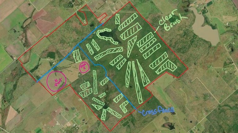
When Spring Creek Outdoors started working with Draw Maps, team members were pleased to see that the app allows them to choose a surveyed area of interest—called a Collaboration—and load it into their mobile devices. From there, they can discuss the map with their clients and annotate it using the drawing tools of their choice. The resultant sketches are immediately transferred to ArcGIS Online, where staff back at the office can follow the field crew in real time and start working on the clients’ issues right away—even while the surveys are still under way.
“Draw Maps provided exactly what I had been wishing for,” said Ledbetter. “Our clients have been very excited about Draw Maps and always ask if they can have a copy of the annotated map.”
Fortunately, Draw Maps makes it easy for Spring Creek Outdoors to share marked-up maps as well. Field crews can share documents with clients using AirDrop, text, or email. Clients can open documents in the consumer version of Draw Maps and continue editing them on their own devices.
Bringing a Biologist’s Vision to Life
Spring Creek Outdoors really discovered how helpful Draw Maps could be when a new client arrived with approximately 1,200 acres of wild land to survey and restore.
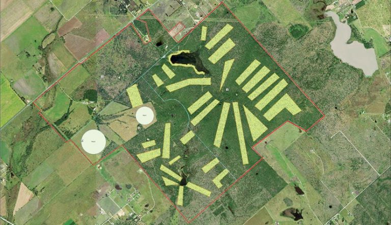
First, Spring Creek Outdoors’ biologist used the aerial imagery to make adjustments to the property boundaries, which were taken from a fragmented paper map. Then he used Draw Maps to sketch in the areas that needed to be cleared of overgrown brush and restored to native grassland. After that, he drew in areas to be irrigated to encourage native growth and sketched out where to put partition fencing to divide the types of wildlife that would be managed separately. The landowner and contractors were able to use the resultant maps to visualize and plan out the recommended work.

“An experienced wildlife biologist can stand on a high spot on a property and visualize exactly what needs to be done and what the finished project will look like, but the average landowner has a harder time seeing that in their mind’s eye,” said Ledbetter.
Draw Maps for ArcGIS enables biologists to share their vision with clients. Additionally, the app provides a polished way for the team to make notes and draw directly onto aerial maps while still in the field, yielding solutions that are faster and more accurate than ever before. And after all that, with ongoing help from Spring Creek Outdoors, clients can continue to change and refine the maps, making them into a solid GPS-based document that contractors can use to execute the planned project with precision.
Ledbetter said that the simplicity of Draw Maps is a major advantage because it is easy for employees to learn and use. “Our chief biologist is more interested in animals than technology, but he learned to use the iPad, Apple Pencil, and Draw Maps within an hour. He took it on a job the next day and was able to produce his first map while making it look like he’d been doing it for years.”
For more information on how Spring Creek Outdoors uses GIS and Bluefield GIS Draw Maps for ArcGIS, email or call 325-623-5464.

