This year marks a decade since the Cadasta Foundation (an Esri partner) was established with a simple, powerful idea: that maps can do more than define boundaries—they can unlock land tenure rights, economic and social opportunities, and environmental resilience.
Powered by Esri technology, Cadasta’s platform and training have helped communities in 50 countries map more than 115,800 square miles of land, advancing land rights for more than 7 million people. By making land rights visible, GIS-based tools give people access to legal protections, advisory services, and a more secure future.
A Mission Born from the Global Land Data Gap
More than 1 billion people live and work on land without formal legal recognition, leaving them vulnerable to eviction, conflict, and ecological risk. Indigenous peoples, local communities, women, and youth are disproportionately affected.
For example, while Indigenous peoples and local communities manage 54 percent of the world’s remaining intact forests, they legally own only 11.4 percent of them, according to the World Resources Institute. This stark gap highlights the urgency of recognizing the rights of those who care for the world’s most critical ecosystems.
Cadasta was built on the understanding that communities already know and steward their land; they simply lack the tools and training to formally document and defend their land rights. The organization’s mission is to democratize access to geospatial technology, making it easier and more affordable for people to claim, protect, and manage their resources.

A Decade of Impact
Since its founding, Cadasta has supported more than 100 projects in 50 countries. The organization works at the intersection of community action and institutional reform—bridging local communities and governments to ensure that land systems reflect realities on the ground. Using mapping, the organization helps people defend their identities, aids communities in deepening their resilience, and aims to build a just and sustainable future.
Alongside delivering technology and training to communities, Cadasta provides advisory services to governments to help land administration systems be more responsive, inclusive, and accessible to historically excluded populations. This includes integrating community data into official systems, training government officials on participatory practices, and advising fit-for-purpose land administration.
Cadasta’s globally distributed team of GIS and land specialists, trainers, and regional advisers—along with a committed board of directors, donors, and local partners—has enabled Cadasta to ensure that its approach is technically sound, scalable, and responsive to diverse communities.
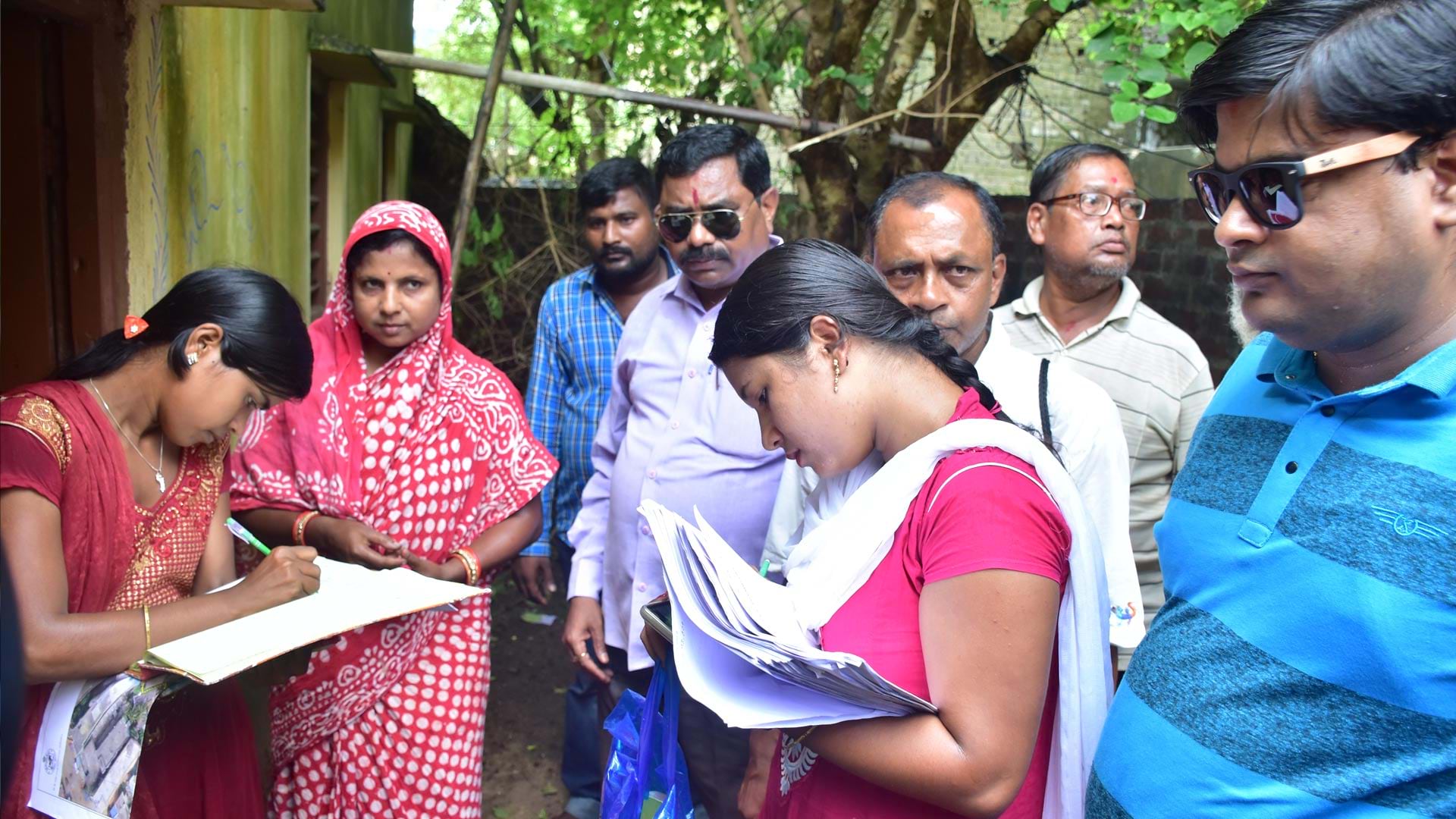
In India, Tata Trusts and the Odisha state government worked with Cadasta to document the property rights of more than 525,000 people living in slums. This supported the issuance of occupancy certificates and broader urban upgrades, benefiting over 1 million people.
In Uganda, the organization collaborated with the Ministry of Lands, Housing and Urban Development, along with the Ujamaa Foundation and the Uganda Community Based Association for Women and Children’s Welfare (UCOBAC), to support the issuance of 5,500 Customary Certificates of Ownership, securing the land for more than 45,000 individuals—nearly 19,000 of whom are women.
In Brazil, Cadasta and Espaço Feminista trained local women and youth to map 15 informal settlements. Using GIS tools, they cut survey times from months to hours. As a result, 1,370 households received formal titles, with 85 percent of those in women’s names or jointly held, and new municipal laws recognizing informal settlements.
In Belize, youth mapper Analita Cal helped document her village’s rivers, farms, trails, and sacred forests.
“This map is very important to the villagers because the younger generation is coming,” she said. “They will get the knowledge and the information about the village—how we use the land, where we live.”
Most recently, Cadasta launched the Strengthening Land and Forest Rights Program, supported by international development funding from the United Kingdom’s Foreign, Commonwealth & Development Office. The program works with 13 local partners around the world to document and secure land for Indigenous peoples, Afro-descendant peoples, and frontline communities. Since its launch, the program has helped document more than 17,000 square miles of land, with 425 square miles submitted for formal legal recognition. Through outreach, training, and mapping activities, the program has reached or supported 400,000 people, including many women and youth.
Technology That Serves People
Since 2019, Esri technology has powered Cadasta’s platform. Built on ArcGIS Online and incorporating other software and apps such as ArcGIS Survey123, ArcGIS Field Maps, and ArcGIS StoryMaps, the platform enables real-time, participatory data collection, even in the most remote and resource-constrained areas. Partners can manage and act on their own data to support land registration, forest monitoring, and urban planning.
Accessibility is a priority. Cadasta’s tools are mobile enabled, offline capable, and usable by people with varying technical skills. Most importantly, Cadasta ensures that communities have ownership and control over their own data and decisions.
The work of securing land rights begins with trust. Relationships come first. Additionally, no two contexts are the same: What works in Colombia may not translate to Kenya. That’s why Cadasta has embedded flexibility into its technology and prioritizes training, follow-up, and long-term support.
Cadasta’s role is as much about relationship-building as it is about technology—linking communities, civil society, and governments through a shared commitment to land rights.
Meeting the Moment
The demand for Cadasta’s approach is stronger than ever. As foreign aid shifts and governments seek to improve their land systems to generate increased revenue, the need for community-centered, data-driven models is only growing.
Land rights are foundational to peace, equity, and opportunity. They unlock access to credit services and sustainability—especially when women and youth are central to the process.
Cadasta will continue to expand its work with Indigenous peoples, local communities, smallholding farmers, and customary landholders while deepening its support for governments. But there is also a larger opportunity: to transform the land administration sector to be more inclusive, technologically enabled, and resilient. This means embracing participatory methods, centering community voices, and addressing long-standing inequalities in land access.
A Call to the Geospatial Technology Community
Ten years ago, Cadasta set out to use geospatial tools to secure land rights. A decade later, the organization has seen how land rights catalyze economic opportunity, resilience, and self-determination.
But Cadasta cannot do this work alone. That’s why we are calling on the Esri user community and the global geospatial technology community to help scale up rights-based mapping and build the next generation of land systems.
We invite technology companies, governments, nongovernmental organizations, and funders to help Cadasta co-create affordable, adaptable solutions and invest in long-term systems that support data sovereignty, community ownership, and local leadership.
Maps are just the beginning. They do more than show boundaries. They represent people, relationships, history, and the future that communities around the world are working to build. Geospatial tools help make that visibility possible. But it’s the people who bring the maps to life.
Together, we can build a world where everyone has the right to stay, grow, and protect the places they call home.