Sabah Al-Salem University City, which will soon contain all the buildings and colleges associated with Kuwait University, is “one of the largest educational campuses in the world,” according to its website. Known as Sabah Al-Salem University City—Kuwait University, or SSUC-KU, the campus is one of Kuwait’s main development projects. GIS has been the backbone of SSUC-KU’s project life cycle since the beginning and will continue to shape day-to-day activities at the university for years to come.
Managing All Data and Assets with GIS
Previously, Kuwait University’s colleges were scattered in different locations throughout the country. Traffic around those campuses was severe, and the buildings couldn’t absorb the growing number of students.
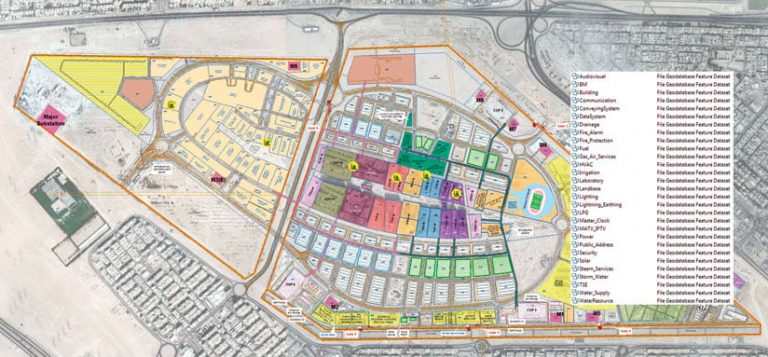
The new, consolidated SSUC-KU campus has all the facilities and amenities needed to offer a modern education. In all, SSUC-KU’s two campuses span 6 million square meters (2.3 square miles) and are designed to accommodate 40,000 male and female students, divided equally into male and female buildings to preserve Kuwait’s traditions as an Islamic Arabic country. The main campus, which contains the university’s 11 humanities and scientific colleges and covers 4 million square meters (1.5 square miles), consists of 22 buildings. The health sciences campus, which is still being designed, will fill 2 million square meters (.75 square miles) and host the university’s 5 medical colleges in about 25 buildings.

The intention is to manage all SSUC-KU data—whether spatial or nonspatial—and assets using GIS. To achieve that, the campus’s master plan was developed alongside the first version of its GIS data model, built using a combination of Esri’s industry-specific data models, which cover all expected services, such as water, electricity, and telecommunications. As the construction process got under way, the data model needed to be extended to absorb new datasets, feature classes, domains, and subtypes. The latest version of the data model contains 29 datasets, 433 feature classes, 58 geodatabase tables, and 21 relationship classes.
As some of the colleges on the main campus were getting ready to receive students, which will happen this September, the team at Openware, Esri’s official distributor in Kuwait and the GIS consultant on the project, used ArcMap and ArcGIS Pro intensively to ensure a smooth transition from the old university to the new campus. In fact, GIS became the primary decision-making tool at this time. Staff in various departments requested hundreds of reports to help them locate their spaces and services on maps. For example, employees in the department of libraries requested maps showing all the library facilities in each building so they could arrange their supplies and revamp their workflows. Staff in the services department, meanwhile, requested maps showing all the electrical rooms, telecommunications pathways and spaces, and more throughout the campus so they could situate their teams appropriately.
A Portal, Some Apps, and a Dashboard
Once the campuses are in full service, university staff, faculty, students, and visitors will need to be able to find various buildings and rooms, figure out where they need to go, and work out what they need to do on the new campus. Thus, Openware recently developed a bilingual—Arabic and English—mobile portal that contains search apps. The locate subsystem within the portal is built on Elasticsearch technology and utilizes the ArcGIS Indoors Information Model, which draws a route for each search result based on the user’s current location. The portal also includes outdoor mapping functionality, which contains a map that shows the campus’s street network and basic outdoor infrastructure, taken from the SSUC-KU master plan. The map can even be extended beyond the campus—and throughout the entire state of Kuwait—to make navigation to and from the area seamless.
The mobile portal contains various apps as well. One app allows inspectors with special privileges to generate work orders and assign tasks to field maintenance crews. The app consumes ARCHIBUS database tables inside Survey123 for ArcGIS forms, which together, with their standardized forms and tables, make it easier for inspectors to manage campus assets. For students, there is a study schedule app that provides users with academic information, including the course name, lecturer bio, place, and time; the academic calendar; a list of important dates for students and staff; and even a route map for how to get to specific classes or labs. Additionally, there is a geonotifications app that administrators can use to send alerts to university staff, faculty, students, and visitors about specific events or emergencies. Users will receive these notifications on their cell phones based on their location, movement, or nearby events.

To get the mobile portal and its apps working perfectly, the Openware team developed a web app to manage the administration web page. This lets users with administrative permissions set roles and privileges for other users and administer and configure push notifications.
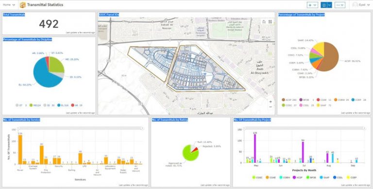
Of course, the flow of data through SSUC-KU’s GIS, typically called “flow of transmittals,” is massive. Hence, it was necessary to control this process using a dynamic dashboard, which the Openware team built with Operations Dashboard for ArcGIS. The dashboard shows the number of transmittals by month, discipline, project, and business, as well as the review results for submitted packets of data, which are designated as approved, rejected, or accepted with notes. To show these statistics on the dashboard, it was necessary to design an ArcSDE table that specific users can access and edit to keep information up-to-date. Editing and tracking are also enabled so that management can know who is doing what and when.
At the campus level, water and electricity networks are managed and updated using Esri partner Schneider Electric’s ArcFM solution, which is installed on top of ArcGIS Desktop. The campus’s telecommunications network, however, is managed and updated using GDi Ensemble from Esri’s official distributor in Croatia, GDi.
Planning for the Future
With SSUC-KU’s health sciences campus currently under design, the project team is incorporating even more sophisticated enterprise technology. To support the operations and decision-making processes, for example, this campus’s building data will be delivered in a building information modeling (BIM) format that is compatible with the university’s current GIS schema. This will allow staff at SSUC-KU to simulate all the buildings and their complete services, including water, electricity, and telecommunications. By 2021, when the health campus is fully designed and construction begins, the flow of transmittals in both GIS and BIM formats will be incorporated into SSUC-KU’s geodatabase, enriching the campus’s GIS content.
For more information, email Eyad Ghattasheh, a GIS consultant at Openware, at e.ghattasheh@openware.com.kw.

