ArcGIS Maps for Adobe Creative Cloud Plus Offers Middle Ground User Option
ArcGIS Maps for Adobe Creative Cloud, a downloadable extension for Adobe Photoshop and Adobe Illustrator, gives creatives an easy way to incorporate data and maps into their designs. And with the new Maps for Adobe Plus user option, released in September 2019, users can now run a number of different visualization tools, designate their most-used maps as favorites, and add demographic data to their projects—all while running the extension in Adobe Creative Cloud.
Prior to Plus, Maps for Adobe was only available with an ArcGIS Online account or as a complimentary extension to Photoshop and Illustrator. Users who opt for the ArcGIS Online account pay a higher price and are provided with all the bells and whistles of Maps for Adobe, as well as ArcGIS apps and services that allow for private sharing within an organization. But some designers and cartographers don’t need everything that comes with ArcGIS Online, so they’ve been able to use the Complimentary option, which operates within Photoshop and Illustrator. While this plan gives users access to public maps and layers hosted in ArcGIS Online, it limits how designers can use the maps and projects they create with the plug-in.
With Maps for Adobe Plus, which costs just $10 per month, users now have access to the visualization tools they need to create exciting, map-based narratives that incorporate sharp design and branding. Users of Plus can also do more with data-driven analysis tools than Complimentary users can. They can bring premium basemaps and hundreds of data layers into their Photoshop and Illustrator projects as well without leaving their Adobe software programs. With Maps for Adobe Plus, designers have full distribution privileges to their maps and designs (as long as they comply with standard Esri attribution guidelines).
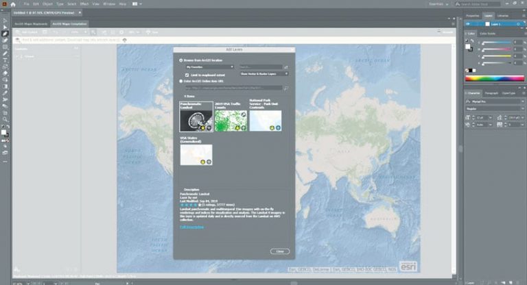
ArcGIS Maps for Adobe Creative Cloud was built with Adobe users in mind. The product’s interface mimics the look and feel of Adobe’s core products, so users have a sense of familiarity when using it. For any project that involves maps, such as illustrations for a book or slides for a sales presentation, users of Maps for Adobe Creative Cloud can design appealing visuals that pull location-based data into easy-to-read maps.
Some of the new things users can do with the advanced features in Plus include the following:
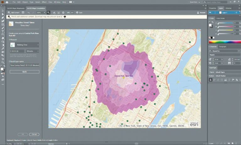
Visualize Travel Time—Similar to the Create Drive-Time Areas tool in ArcGIS Online, the new Visualize Travel Times tool in Plus employs ArcGIS technology to calculate the area someone can walk, drive, bike, or take public transit to within a specified time or distance along a street network. Users can create multiple visualization projects—showing how far someone can walk in three, five, or seven minutes, for example—by entering either the times it will take to travel or the distances to be traveled, separated by a space. This saves designers from having to analyze multiple travel times and distances themselves.

Put Items on a Favorites List—Users can now create a favorites list of items they’ve added to Photoshop or Illustrator from ArcGIS Online. For example, if a designer is working on two separate projects—say, a map of a city’s public transportation options and an unrelated poster that shows where city services are located—he or she can keep track of the basemaps and layers for each project in distinct lists. Once the user has designated items as favorites, he or she can use mapboards in Photoshop or Illustrator to find them.
Add Demographic Data—Maps for Adobe Plus also gives users demographic and landscape data for the people, places, and boundaries associated with specific points, lines, or polygons. It uses ArcGIS GeoEnrichment Service, which provides facts about particular locations and areas, and can enrich any point, line, or area feature. Users can also employ the GeoEnrichment Service to obtain geographic context for their projects, such as a town’s ZIP code or the geographic boundaries for a drive-time service area.
