Established in 1774 in what is now Old Salem, North Carolina, Winston-Salem/Forsyth County (WSFC) Utilities is the second-oldest water system in the United States, according to the company. WSFC Utilities provides high-quality potable water to approximately 381,000 customers.
In 2021, WSFC Utilities began to prepare for new federal-level Lead and Copper Rule Revisions (LCRR), which went into effect last year. These revisions require utilities to inventory their service lines and notify residents when their water pipes are found to contain lead or copper, which can pose a variety of health issues that range from nausea to brain damage.

To help collect and manage its water service line inventory data, WSFC Utilities worked with Esri partner Black & Veatch to implement its LCRR program management platform. The platform uses and adapts Esri’s Lead Service Line Inventory solution to provide powerful analytics and meaningful visualizations using ArcGIS Dashboards, ArcGIS Survey123, and ArcGIS StoryMaps—all hosted in the utility’s ArcGIS Online and ArcGIS Enterprise deployments. This helped WSFC Utilities support public outreach, engage with customers, conduct field investigations, and efficiently replace affected service lines.
GIS Makes Rule Compliance Less Daunting
To reduce risks from lead and copper in drinking water, the Environmental Protection Agency (EPA) established its Lead and Copper Rule in 1991, with the latest revisions announced in 2021. In November 2023, the EPA proposed expanding the Lead and Copper Rule to require utilities to replace all their lead pipes within 10 years, with few exceptions; provide regular inventory updates; and strengthen community education.
Complying with these revisions and proposed improvements can be daunting for many water utilities, especially when they are not accustomed to conducting digital inventories. But GIS has helped many water utilities—including WSFC Utilities—update their inventories, monitor sampling operations, and support program management for lead pipe replacement.
Additionally, the revisions have helped many utilities jump-start GIS upgrades and improve their data quality, since the new rules require utilities to give the public access to accurate and transparent information. Apps such as ArcGIS Dashboards and ArcGIS StoryMaps are critical to these endeavors.
A Complete System for LCRR Program Management
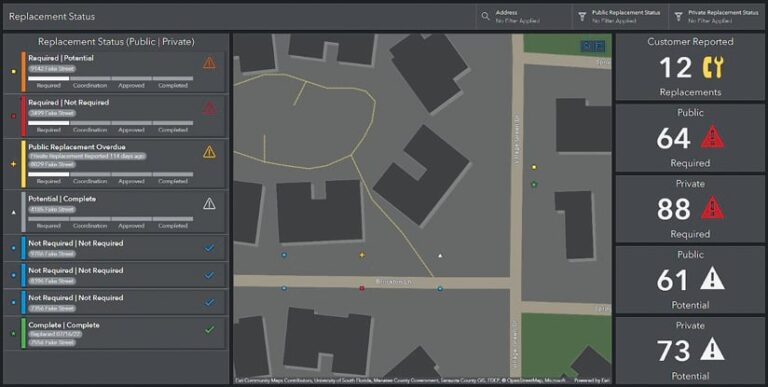
The first phase of WSFC Utilities’ effort to comply with the LCRR included gathering, organizing, and analyzing LCRR-related task data—such as the status of service line inventories and activity related to property damage and leak repairs—in a centralized location in ArcGIS Online. Staff then used ArcGIS Dashboards to build various dashboards that helped monitor the utility’s service line inventories and water sampling program. The use of ArcGIS Arcade expressions enabled advanced formatting of the dashboards to make it easier to track the status of the project as a whole, share curated information with the public, and plan for next steps.

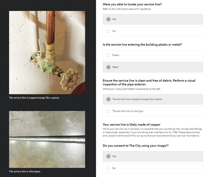
Working with Black & Veatch, WSFC Utilities also developed customer surveys using ArcGIS Survey123 to help track and complete the customer notifications, public education activities, and field investigations that the LCRR requires. The customer engagement aspect of this system—built within WSFC Utilities’ ArcGIS Online environment—is based on Esri’s Lead Service Line Inventory solution. It allows customers to approve access to their properties and enables staff to see, in real time, status updates of both the public and private sides of WSFC Utilities’ field inventories.
“In addition to supporting activities for the LCRR program, the platform [developed by Black & Veatch] has provided us with insight into the quality of our existing data, supported data-driven decisions, and provided opportunities for continual improvement,” said WSFC Utilities information systems lead Matt Whitman. “The overall experience has allowed us to expand our use of advanced geospatial tools and processes.”
WSFC Utilities is also leveraging Python-based predictive analytics to estimate the likelihood that service lines are composed of unknown materials. Mobile crews then use Survey123 to verify these predictions on-site, providing critical feedback that further refines and strengthens the models over time.
Ultimately, according to Whitman, the long-term vision for the LCRR platform and the use of ArcGIS technology at WSFC Utilities is to support the ongoing lateral replacement program, as well as other utility planning and asset renewal programs. And Black & Veatch has been applying the insight it gained and the predictive modeling techniques it developed with WSFC Utilities to many of its other LCRR projects—many of which have already been accepted by the EPA.
“Our success lies not only in creating standardized templates, tools, and processes but also in empowering users to understand the LCRR; why it matters; and how their efforts contribute to the delivery of safe, reliable drinking water,” said Justin Mitchell, senior data scientist at Black & Veach and the lead developer of both the LCRR platform and the predictive model.


