The creation and continuous evolution of the United States National Spatial Data Infrastructure (NSDI), under the leadership of the Federal Geographic Data Committee (FGDC), has provided a crucial foundation for the development of today’s GIS community and the many GIS applications that now abound in our world. Planning is now under way for a new NSDI future, one that responds to evolving mobile GPS/GIS data collection and use technologies and the resultant explosion of real-time spatiotemporal data availability and its dynamic, interactive applications. One step in adjusting the NSDI to this changing world of pervasive real-time geographic data is the recent Strategic Planning process undertaken by FGDC for the NSDI.
The National Spatial Data Infrastructure has been defined as “the technology, policies, standards, and human resources necessary to acquire, process, store, distribute, and improve utilization of geospatial data.” (Executive Order 12906: “Coordinating Geographic Data Acquisition and Access,” 1994.)
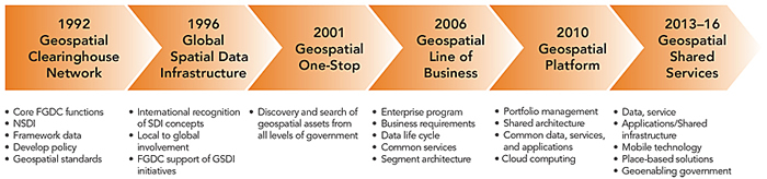
For the past two decades, FGDC has worked to develop policies and partnerships to advance the development of the NSDI. To achieve this, FGDC has contributed to the evolution of federal and national geospatial initiatives. Several of these initiatives have been sponsored as US governmental priorities, and their milestone evolution and key themes are highlighted in the following figure:
A New NSDI Strategic Plan*
As Anne Castle, assistant secretary of the Interior Department and a leader throughout the NSDI strategic planning process, points out, “the NSDI strategic plan describes a broad national vision for the NSDI and includes goals and objectives for the federal government’s role in continued sustainable development of the NSDI. The plan has been developed with input from a variety of sources, including FGDC member agencies and geospatial partner organizations. The National Geospatial Advisory Committee (NGAC) has played a critical role in the development of the plan by providing extensive input and comment.”
The plan is thus a collaborative effort, led ably by FGDC but involving many federal agencies, the private sector, and state and local governments, among others. The plan recognizes the revolutionary changes in geographic science and technologies and the growing applications of geospatial information across all sectors of the global economy. In response, US public sector agencies must realign their geospatial strategies and investments to meet the needs of rapidly expanding real-time geospatial information and technology users. And increasingly, citizens expect governments to provide geospatial data and services to them in their specific areas of interest or need.
The new NSDI plan focuses on adapting to a rapidly changing set of external factors, such as these ongoing and future trends:
Work Force: There will be increasing demand for skill sets positioned at the intersection between the traditional IT and geospatial realms, such as application and services development, geoinformation fusion, crowdsourcing, social networks and human geography, identity management, visual analytics, and forecasting/modeling.
Technology: Geospatial technologies will be called upon to organize a much larger information domain, provide trusted analysis of complex “big data” holdings, and effectively visualize and communicate knowledge so that it can be turned into operational efficiencies. The “Internet of Things” will connect billions of stationary and mobile sensors with human users.
Communications: Systems for information delivery will become ubiquitous and highly mobile, will utilize web-based services, and will be integrated components of more advanced information workflows. Harnessing content provided by sensors and social media, particularly in the form of feedback to enhance authoritative processes and products, needs research and strategy. Additional attention is needed with regard to the measurement and expression of the uncertainty inherent in geospatial information and related analytical products.
Legal and Policy Contexts: State, tribal, regional, and local geospatial resources will continue to improve and, in many areas, may provide the best sources for ongoing current and accurate information. Integrating these diverse datasets involves coordinating numerous legal and policy frameworks. Thoughtful approaches are needed to develop consensus terminology; develop policy; and educate citizens and decision makers with regard to geospatial data gathering, dissemination, and usage. Geolocation privacy, confidentiality, and security issues may need to be addressed for sensitive geospatial information.
Full details on the assumptions, analysis, and recommendations of the new NSDI Strategic Plan are available online, and the plan itself can be accessed [PDF]. While this plan focuses primarily on the federal role in achieving the shared national vision for the NSDI, the successful implementation of the specific goals and objectives in the plan will require coordination with a wide range of nonfederal partners and stakeholders, including you.
How You Can Help Shape the Future NSDI
FGDC plans to work closely with NGAC and other organizations and individuals to collaboratively develop and maintain the nation’s critical geospatial infrastructure. Anne Castle emphasizes that “we will work with FGDC member agencies and partners to develop more detailed project plans and milestones for the goals and objectives in the [NSDI] plan.” I join Assistant Secretary Castle in inviting all of you in the Esri GIS community to participate in the ongoing process of developing implementation plans for the NSDI. Contact FGDC or members of your GIS community on the National Geospatial Advisory Committee to make your voice heard. (Additional information about NGAC, including a list of committee members, is available.) I now serve on this committee, and Jack Dangermond has provided highly valued guidance to this committee for many years.
And, perhaps most importantly, continue to push forward with all the innovative GIS development work that has long characterized the vibrant Esri GIS community, as it is with our continued work to create and innovate and develop the field of GIS and geographic technologies, and their new applications, that we will most directly shape, tangibly and on the ground, the future of the NSDI.
*Federal Geographic Data Committee, 2013, National Spatial Data Infrastructure Strategic Plan 2014–2016: Reston, VA [PDF]; Federal Geographic Data Committee, 19 p. Some of the descriptive text and the figure contained above in this column are from the final plan.