The City of Gresham, Oregon, Implemented ArcGIS Enterprise and LucityAM to Improve Its Critical Public Service Infrastructure Data
Gresham, Oregon, which lies about 15 miles east of Portland, is the state’s fourth-largest city. While it’s a city that treasures its agricultural and homesteading history, the area is growing rapidly, and residents are passionate about building a smart community.
Part of this entails better managing critical public service infrastructure, which includes assets related to water, wastewater (collection and treatment), storm water, transportation, and parks services. These assets fall under several city departments, including environmental services, budget and financial planning, and innovation and information.

To address this in the context of an expanding city, Gresham adopted a comprehensive asset management strategy as part of the Strategic Technology Plan it released in 2014. Two solutions eventually emerged that, together, serve as the core platform for implementing the plan: Esri’s ArcGIS Enterprise and LucityAM from Esri partner Lucity.
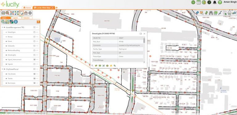
The primary goal was to gain a thorough understanding of the city’s assets with an eye toward managing them long term in a cost-effective way. With ArcGIS Enterprise, the city was able to create a location-based registry that now serves as the system of record for all of Gresham’s public service assets. This is linked to the LucityAM solutions platform, which is the system of record for asset maintenance. From there, the city has been able to build up an arsenal of GIS-based maps, apps, and dashboards that help staff streamline their workflows and improve efficiency.
Initial Challenges Elicit a GIS Road Map
While ArcGIS Enterprise is hosted on-premises, LucityAM is a software-as-a-service (SaaS) solution that Gresham chose to host in a cloud environment. This posed challenges for integrating the two. It had the potential to limit the city’s ability to deliver maps and apps to field crews on their mobile devices and could have affected workflows that require recording field data simultaneously in the Lucity and ArcGIS environments.
To overcome these obstacles, the city’s GIS and IT teams developed a road map to modernize Gresham’s ArcGIS deployments. It involved implementing ArcGIS Enterprise 10.7, which would enable the city to better leverage capabilities such as field mobility, streamlined integrations, online (cloud) data management, web mapping, configurable out-of-the-box apps, and analytics.
A key part of this road map involved having the city link its GIS-managed asset registry with LucityAM, making this the standard model across the enterprise for managing asset data and engaging with location-centric information. This configuration ensures that quality-assured asset data comes from a single, authoritative source and is available to LucityAM. That way, the City of Gresham can confidently monitor asset conditions and any work or inspections being done on assets.
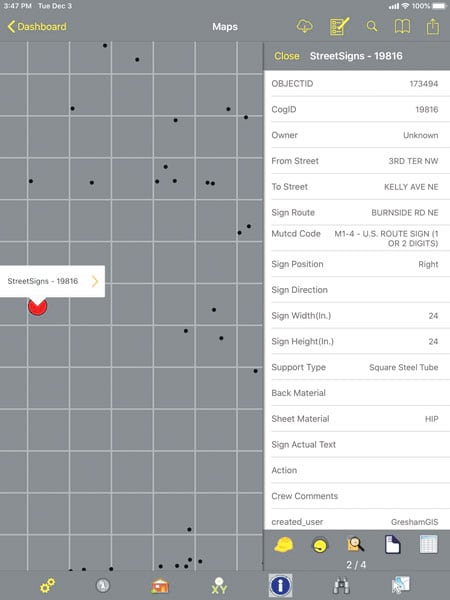
This setup allows users to make changes to asset records in the field using Lucity Mobile, a field app that’s integrated with Collector for ArcGIS. And the quality assurance process ensures that changes made in the field get reviewed by city staff before they’re included in the ArcGIS Enterprise-based asset inventory. From there, the GIS team can validate the city’s asset data based on crews’ field knowledge and then leverage ArcGIS technology to create maps, apps, and information products that enrich Gresham’s overall maintenance strategy.

Several Ways to Think Strategically About Assets
Since going live with LucityAM a year ago, the City of Gresham has streamlined how it collects data in the field and manages it in the enterprise geodatabase. This has, in turn, made it easier for the city to take advantage of other Esri technology as well, including ArcGIS Online, ArcGIS Pro, Collector for ArcGIS, Survey123 for ArcGIS, ArcGIS Insights, and Operations Dashboard for ArcGIS.
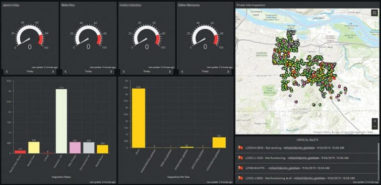
Now, for example, the city’s environmental services department uses Collector and Survey123 to gather storm water asset inspection data in the field, and the records are stored in feature layers hosted in ArcGIS Online. Members of this team then visualize the data using Operations Dashboard, which provides them all with a common operating picture and allows them to monitor asset inspections, confirm asset attributes, and ensure that field crews are doing proper asset maintenance.
In addition, the city’s GIS team now uses ArcGIS Pro and ArcGIS Online to create maps and apps that help staff members and the community find and visualize information about street reconstruction projects, traffic counts, the city’s hydrant flushing program, and more. And field crews use Survey123 and Collector, rather than paper-based workflows, to validate asset locations and perform field inspections.
The GIS team also uses Insights to conduct various types of analyses that help city leaders make data-driven decisions. With its simple and dynamic maps, charts, and tables, Insights helps city managers and supervisors analyze asset and maintenance management data to improve asset performance. Insights helps the GIS team identify hot spots that might indicate critical failure points throughout the asset network and then put together state-of-the-art asset reports that city leaders can use to order targeted asset maintenance. This ensures that there is a clear line of sight between what the city invests in asset management and the community’s service-level expectations.
“The impact of ArcGIS tools combined with the Lucity platform on meeting the city’s objectives has been significant,” said Chris Strong, the City of Gresham’s transportation division manager. “We are starting to see greater efficiencies across our operations and an improved ability to think strategically about asset investments. It also is causing us to reexamine other business processes and workflows, which can promote better effectiveness in how we deliver services.”
More Accurate Data Leads to Lots of Improvements
The City of Gresham has realized a number of key benefits in using ArcGIS Enterprise and Lucity’s asset management solutions. They include the following:
- An accurate, consolidated asset registry. Having a centralized ArcGIS geodatabase that’s full of asset information operating in conjunction with a centralized enterprise asset management system ensures that asset data is always accurate and relevant. For example, the city’s transportation division used to keep its asset registry for traffic signs on a single computer outside the ArcGIS geodatabase. This architecture, which bypassed typical quality assurance processes, was simpler to maintain, given how often signs have to be installed and modified in Gresham, but it resulted in having what was essentially a stand-alone record that most city personnel couldn’t access. By implementing ArcGIS Online and ArcGIS Enterprise, however, the city was able to migrate this data to Gresham’s comprehensive geodatabase. Now, a wider range of end users can get accurate information about traffic signs.

- Dispensing with separate asset management systems. As users at the City of Gresham learn the value of having a spatially relevant collection of asset data and work records, they are abandoning the separate asset management platforms, databases, and spreadsheets they used to use. For instance, a database that was set up to track how the city responds to illegal dumping in Gresham’s storm water system is getting moved to LucityAM, where it is being integrated with a map that shows related assets—such as inlets, pipes, and manholes—that may influence how the city responds.
- Improved communication. LucityAM’s configurable dashboard allows users to select and visualize work orders based on certain criteria, including who is managing the work order and when a response is expected. This has been helpful, in particular, for managing requests related to streetlight outages, since information is often passed among city staff, contractors, and the electric utility en route to resolving the issue.
- Timely tracking of expenses. When an asset is damaged, the City of Gresham can now use a map to identify which asset it is and then use LucityAM to keep track of all the labor and materials costs that go into repairing or replacing it. This allows the city to get reimbursed for damaged assets more quickly.
- Being able to prioritize assets for repair and replacement. The City of Gresham is currently exploring how to take several streams of integrated data and link them to consolidate capital improvement projects. For example, Gresham is embarking on a multiyear project to repave a quarter of its streets. Using ArcGIS and Lucity software, city leaders have been able to identify where this project coincides with underground assets that are in poor condition. Now, when the city closes streets for repaving, engineers can get to the underground assets while the pavement is stripped and fix or replace them before the new pavement goes down. Not only does this coordinated process provide a timelier, more cost-effective schedule for replacing utility assets, but it also cuts down on how often traffic gets impacted by street closures.
Effective Data Governance Produces a Smarter Community
Now that the City of Gresham has one system of record that streamlines its asset information and associated inventory and maintenance schedules, city staff can be assured that, no matter where or how they access the data, it is quality assured and authoritative. With the location intelligence capabilities of the ArcGIS platform working in step with the comprehensive tools of LucityAM, asset managers can ensure effective and efficient data governance. All this means that the City of Gresham can operate its critical public service assets at their lowest possible life cycle costs. That’s the way to build a smart community.


