In the United States, before any construction project begins—especially large, infrastructure-scale projects such as those funded by the recently passed $1.2 trillion Infrastructure Investment and Jobs Act—developers must complete several state and federal environmental impact assessments.
These government-mandated assessments provide critical data about the natural environment that surrounds a project. Civil engineering and construction firms leverage this data to develop resilient assets that mitigate disturbances to the natural environment and avoid costly future complications caused by ecological conditions.

To help environmental scientists efficiently collect accurate preconstruction data, Ecobot—an Esri partner that recently graduated from the Esri Startup program—developed a platform for completing these assessments. It works seamlessly with ArcGIS Field Maps and ArcGIS Pro.
One area of focus for Ecobot is helping developers determine the locations of wetlands. When completing preconstruction environmental impact assessments, natural resources consultants must submit the findings of wetland delineations to federal regulators. The results of their findings influence how that land can be developed.
The Ecobot platform, which consists of a mobile app and a desktop app, mirrors industry-standard procedures for this kind of data collection. It automates the calculations used to determine the presence of wetlands and populates government regulatory forms for submission. It also makes the geospatial data available to export directly to ArcGIS Pro.
When consultants at Environmental Science and Engineering (ESE) Partners were contracted to delineate wetlands on a proposed 3,000-acre solar farm in Texas, the company had just two weeks—instead of the several months it would normally take—to complete the project. With only two wetland scientists available at the time, ESE Partners employed the Ecobot app alongside ArcGIS technology to expeditiously find and record hundreds of isolated wetlands and other water elements.
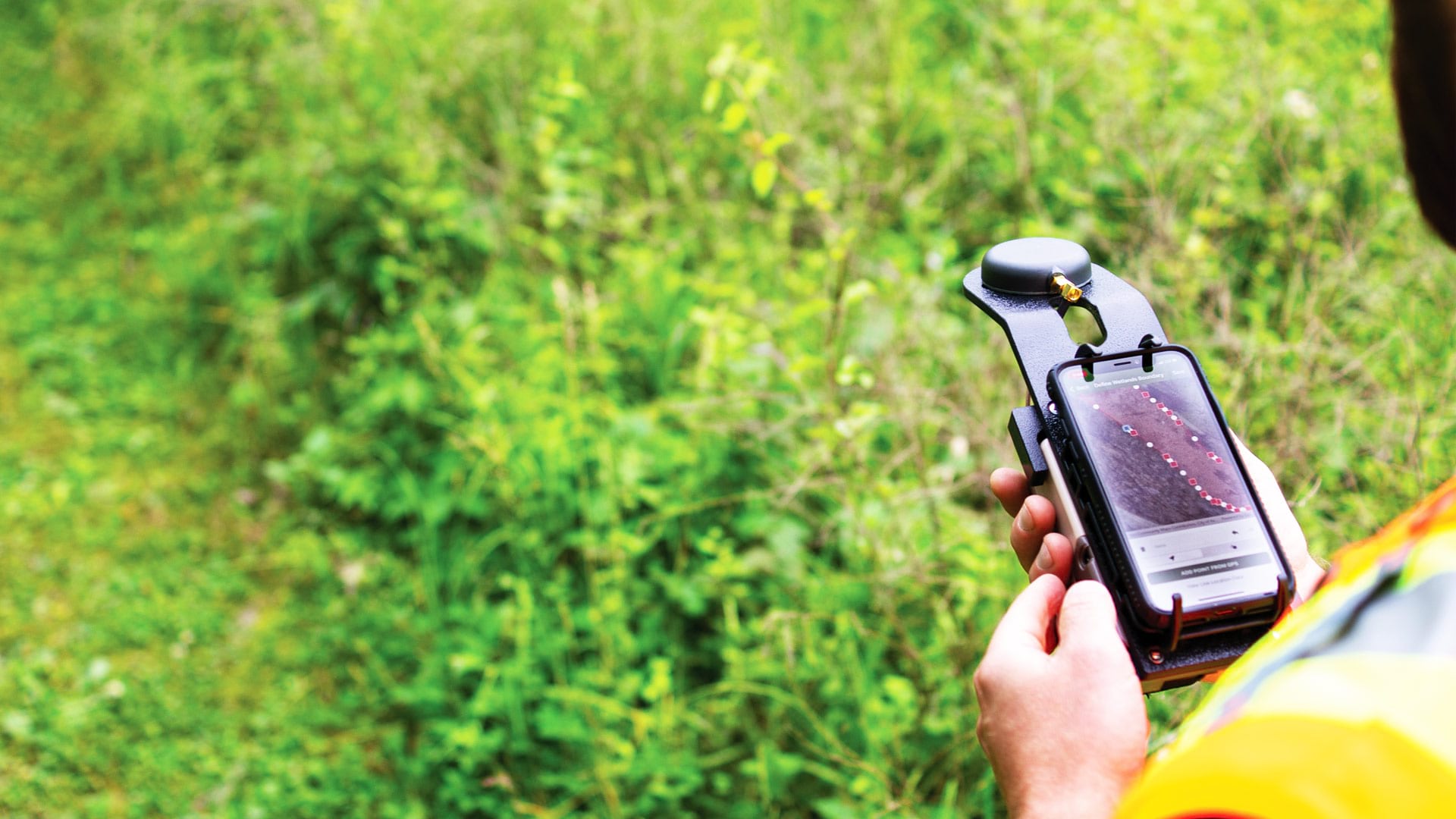
To determine whether an area contains wetlands, environmental consultants collect soil, vegetation, and hydrology data at various points around the site. Prior to the availability of mobile technology like Ecobot and Field Maps, this process required consultants to print out an aerial image of the site and bring that with them so they could approximate their locations while manually collecting data. After that, a professional surveyor would come in to record the data point locations at a higher level of accuracy. This step added at least a day to the project timeline and could cost tens of thousands of additional dollars, depending on the size of the project.
Jeremy Schewe, chief scientist and cofounder of Ecobot, used to work this way. In his nearly two decades of experience doing field research, it typically took him two days to assess a 90-acre plot of land, and then an extra day for the surveying work to be completed. And none of that includes the precursory research and data compilation that had to be done, nor does it include the time it took to transfer the data to government forms and perform quality assurance.
Using Ecobot in conjunction with Field Maps, Schewe can now complete all the work for evaluating a 90-acre plot of land in one day.
“I’m able to work twice as fast, with greater confidence in the accuracy of the decisions being made that impact land use,” he said.
This is what Nevin Durish, a senior biologist at ESE Partners, experienced when using Ecobot and ArcGIS technology during the Texas solar farm project.
“In the field, we were able to complete 31 wetland sample points during a single day because of Ecobot,” he said. “[That’s] more than twice our usual productivity.”
Integrating Ecobot with ArcGIS technology was a no-brainer for Schewe and his cofounder, Ecobot CEO Lee Lance. Schewe said that he and most of his peers in the industry were already accustomed to working with ArcGIS technology to create the detailed, layered maps they used for preliminary research and to compile their final reports.

“Esri is the number one geospatial software provider in the industry. It’s critical that Ecobot and ArcGIS work together,” said Schewe. “Before beginning fieldwork, we can export shapefiles from ArcGIS Pro to Field Maps and then view the map during data collection. I can see all the critical geospatial information when I’m out there and where I am in respect to that. Once I’m finished logging data in Ecobot, I can export a shapefile from Ecobot directly onto the basemap that was created in ArcGIS Pro.”
Ecobot is also compatible with Global Navigation Satellite System (GNSS) devices, such as those from Esri partners Trimble and Eos Positioning Systems, Inc.
Teams from some of the largest environmental and engineering firms in the United States have started using Ecobot in their mobile operations.
Kelley Samuels, senior ecologist at multinational engineering firm and Esri partner AECOM, said that Ecobot is “invaluable for new construction, especially large-scale projects.”
Sarah Soard, environmental project and technical services manager for natural and cultural resources at consulting firm and Esri partner Burns & McDonnell, said that having the real-time calculations that Ecobot provides is valuable “because they eliminate human errors or delays.”
Darin Welch, associate vice president for geospatial and virtual engagement solutions at infrastructure solutions firm and Esri partner HNTB, learned about Ecobot at Esri’s 2019 Geodesign Summit. His company is heavily invested in digital twins, and he sees value in integrating natural environment data, which Ecobot can provide.
Since launching in 2018, Ecobot has grown to serve more than 1,360 customers that have generated over 60,000 field reports for more than 6,500 assessment projects. With a recent venture capital investment of $2.81 million, Ecobot is now in a position to widen the scope of its app, incorporate workflows for additional environmental permits, and add project management tools to the platform.