
Since its founding in 1969, Esri has focused on empowering customers to use GIS to uncover hidden insights in complex data. ArcGIS has long provided users with a comprehensive platform for conducting spatial analysis, creating visualizations, and making sound decisions. Now, Esri is enhancing ArcGIS by infusing it with AI in a way that’s secure, trustworthy, and designed to deliver real value.
Over the past few years, Esri has made strong progress across two core areas of geospatial AI. First, there are AI tools and models that have advanced the science of GIS by automating information extraction, classification, and understanding. Second, there are AI assistants that have been progressively introduced to modernize everyday GIS work—helping users navigate tools, write code, and move forward with confidence while remaining in control of their workflows.
Esri is now building on this with agentic AI, which lets external agents connect to ArcGIS tools and enables users to build geospatial agents that automate GIS workflows and power apps. These capabilities will extend the reach and impact of GIS beyond traditional users while remaining grounded in geography, transparency, and user control.
But before looking at what’s on the horizon, it’s helpful to understand how we got here.
AI Tools and Models Advance the Science of GIS
AI tools and models have allowed many organizations to scale up their GIS and save time by automating the extraction, classification, and detection of information from imagery, text, video, point clouds, and more. A small local government team, for example, can use AI to detect, in imagery, where summer tourists go so it can better plan transit to those places. These tools and models enable advanced spatial analysis through pattern recognition, prediction, and forecasting.
Esri’s pretrained models have helped many organizations get up and running with AI quickly, since large volumes of training data and computing resources aren’t required. Additionally, for organization-specific workflows—such as detecting invasive species that damage native vegetation—Esri provides tools so users can train their own models when appropriate.
Geospatial foundation models are new to Esri’s collection of pretrained AI models. They learn broad patterns from large-scale, multi-modal Earth observation data to perform pixel classification, land classification, and object detection. They require minimal training and are adaptable to many workflows, such as inspections or environmental monitoring.
Esri is now developing foundation model capabilities to accelerate analysis across ArcGIS. Two models focus on imagery. One is a remote sensing foundation model that’s trained on trusted sources such as Landsat, Sentinel, and the National Agriculture Imagery Program (NAIP), and the other is a vision language model that combines imagery with natural language to support map-based queries and analysis. A third model generates location embeddings from tabular and demographic data—enabling a company, for instance, to pinpoint ideal store locations based on key socioeconomic profiles. Together, these models extend ArcGIS analysis capabilities, helping organizations quickly turn multimodal data into actionable insights.
AI Assistants Accelerate Workflows
In recent years, Esri has progressively introduced AI assistants across ArcGIS. While a few of these assistants are generally available, many are still in beta or preview. But they already represent a meaningful shift in how people interact with GIS. Now is a valuable time for organizations to enable assistants, try them out, and share feedback with Esri so these experiences can continue to evolve with user needs.
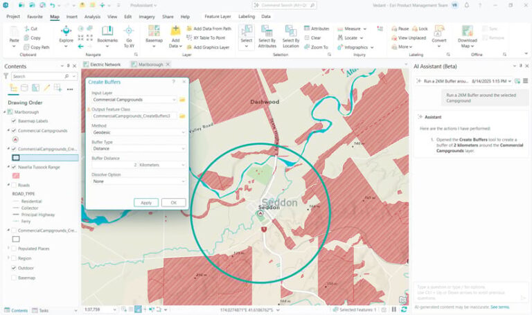
AI assistants in ArcGIS are designed to support users directly within the ArcGIS apps they already use. Users are in full control as assistants provide contextual, natural-language guidance on what tool to use next, how to write code, or how to approach specific workflows. For example, a user working in ArcGIS Pro can ask the assistant which tool to use to create a buffer or get help generating Arcade expressions to perform on-the-fly calculations.
Beyond productivity, AI assistants play an important role in onboarding and skills development. Rather than replacing learning, assistants reinforce it by providing relevant, in-the-moment answers to questions. They help new users progress with their work while gradually building familiarity with GIS concepts, tools, and best practices.
Get the latest information on AI assistants in ArcGIS.
Agentic AI Expands the Impact of GIS
Agentic AI is Esri’s next step in making geospatial intelligence accessible across organizations. Esri’s approach to agentic AI is headed in two complementary directions: bringing GIS into broader agentic ecosystems and introducing agentic capabilities directly in ArcGIS.
Geoenablement: Putting GIS in Agentic Ecosystems
Across the tech industry, organizations are developing agentic platforms with software that uses large language models (LLMs) to reason, take action, and work toward defined goals. However, these agents are only as effective as the data and tools they can access. Without authoritative geographic context, their spatial understanding is incomplete.
Esri is geoenabling these agentic ecosystems by making authoritative GIS capabilities accessible to external agents. Through support for the Model Context Protocol (MCP), third-party AI agents connect to spatial data and tools in ArcGIS, allowing them to incorporate geospatial intelligence into their reasoning and outputs.
For instance, an agent configured in a business platform may be asked to analyze pedestrian patterns in a city. Without access to ArcGIS, that agent lacks the spatial data and tools needed to address this query. MCP provides a standardized way for that agent to call ArcGIS capabilities and return spatially grounded results.
By making GIS AI-ready through MCP, Esri expands the reach of geospatial intelligence beyond traditional GIS users, incorporating location awareness into the tools and workflows people already use. Esri is working toward supporting MCP across ArcGIS Enterprise, ArcGIS Online, and ArcGIS Location Platform.
Geocentric: Building Agentic AI in GIS Workflows
In parallel, Esri is introducing agentic capabilities in ArcGIS by building geospatial agents that can interpret and work with maps, layers, and other authoritative, structured spatial data. This geospatial intelligence differentiates geospatial agents from generic ones, which often generate outputs that are disconnected from real-world geographic context.
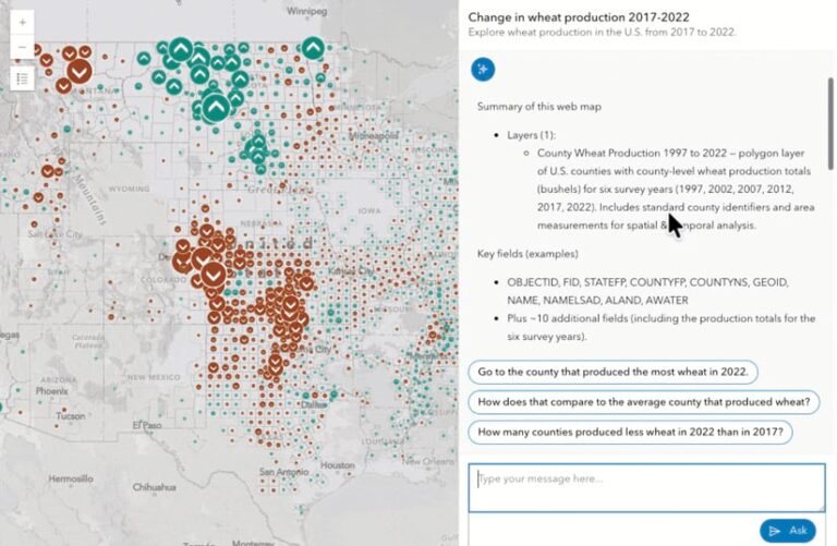
Geospatial agents operate behind the scenes to strengthen assistant experiences. They also power agentic mapping apps, which allow users to ask questions in plain language and receive results that correspond to the user’s intent, the map, and the data. For example, an employee at a public sector organization could use an agentic mapping app to ask, “How many counties produced less wheat in 2022 than in 2017?” The agent interprets the question, runs the appropriate spatial analysis tools, and returns results without the user needing to know how to run the analysis.
To show this vision in action, Esri is introducing AI components in ArcGIS Maps SDK for JavaScript. These components, which are currently in beta and available to try, include out-of-the-box geospatial agents for common map interactions, as well as the ability for developers to create custom agents tailored to their workflows.
Esri is also delivering the Data Explorer template for ArcGIS Instant Apps. Data Explorer, in beta, enables organizations to configure web maps that are powered by Esri-built geospatial agents. Maps configured with the template let users ask questions to a chatbot that searches, describes, and visualizes data on the map.
Across these experiences, agents operate on authoritative GIS content, follow defined rules, and remain under user oversight.
Designed for People, Built on Trust
As AI agents experience widespread adoption across the tech industry, Esri’s development of this new technology remains grounded in user feedback. Staff have been listening closely to customers and recognize both the excitement and concern that accompany conversations about AI.
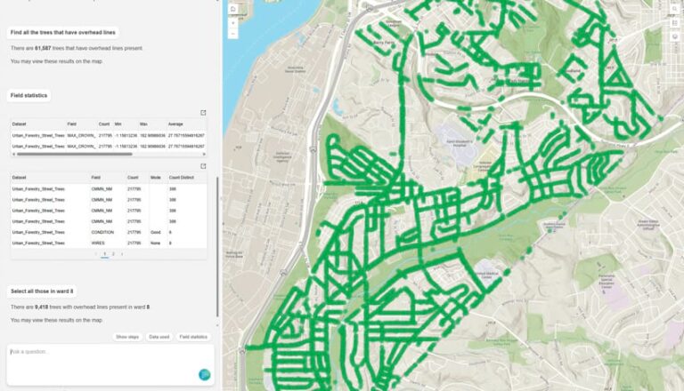
Agents and agentic workflows certainly introduce greater capabilities and automation to GIS, but AI in ArcGIS remains a tool. From the start, Esri has focused on creating products that support and empower people—and AI agents are no different. They are designed to enhance how users work with geographic data, not wrest control away from them.
Even as AI takes a more central role in technology, true autonomy and decision-making remain the user’s responsibility. By keeping people at the center of technological development, Esri delivers AI capabilities in ArcGIS that are powerful, responsibly developed, and trustworthy. For more information, go to the ArcGIS Trust Center.
Looking Ahead
Geospatial AI is expanding beyond standalone tools and models toward intelligent agents that understand context. And Esri’s mission remains the same: advancing spatial science and supporting the vital work of the GIS community. That includes helping users employ AI to improve collaboration and amplify the impact of GIS.