All good things come to an end. This is my last “Relevance of Cartography” column in ArcNews, closing out my part of this series, which coincided with my four-year term as president of the International Cartographic Association (ICA). That makes this a good moment to reflect.
I have written these columns with a wink. The aim of the ICA is to promote the discipline and profession of cartography internationally. The organization offers its expertise and knowledge of technical developments in the field of cartography to others via events, meetings, workshops, and publications. We can only do this, though, with input from ICA members, who share their knowledge via commissions and working groups.
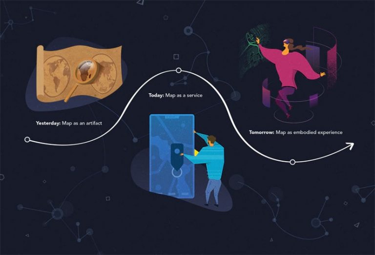
Over time, the discipline of cartography has changed considerably. Not long ago, the map was considered an artifact, a static object visible on paper or a fixed screen. But today, with the Internet, there has been a huge increase in data access and generation, which has resulted in many more maps being produced and used. Thus, maps are no longer artifacts. They instead serve as digital map services. And tomorrow, what constitutes a map will change again.
Currently, we are able to sense and monitor the world ubiquitously and in real time, including human users’ spatial skills, emotions, and needs. With developments in interface design linked to virtual and augmented reality, maps are getting even closer to our human processing system (i.e., the brain and how it processes things). Maps will increasingly become human-centered, highly interactive, dynamic, and adjustable smart visual displays. Based on these technological advances—and their social acceptance, of course—cartographic education and research will be called on once more to adapt.

To face this future, it is important that the ICA has an integrated research agenda in place, along with an established body of knowledge.
A good research agenda asks pertinent questions related to both contemporary and future domain-specific problems within a societal context. ICA’s first research agenda was published in 2009. For some subdomains, such as location-based services, geovisualization, and cognitive and user issues, several ICA commissions have produced extensions and updates to this research agenda. However, the original idea to create a truly living research agenda has, so far, not been realized.
According to Wikipedia, a body of knowledge (BOK) “is the complete set of concepts, terms, and activities that make up a professional domain, as defined by the relevant learned society or professional association.” A BOK can be used to plan new curriculum or position existing curriculum among the rest of the geospatial disciplines. The most well-known BOK in the geospatial realm is the Geographic Information Science & Technology Body of Knowledge from the University Consortium for Geographical Information Science. Other initiatives exist as well, but none of them covers the whole cartographic domain.
So, are we cartographers ready for the future of mapping? The answer is ambiguous. As a discipline, we do have a kind of infrastructure in place, given that we have a research agenda and that fragments of a cartographic BOK exist. But both have to be kept up-to-date, which requires time and attention to make improvements. And, most importantly, we have to link the research agenda and the BOK.
The ICA does not own the cartographic discipline, but it does exist to promote and facilitate the discipline and profession of cartography internationally. Our global network allows us to bring together researchers and educators from all over the world who can, together, offer a broad perspective on our discipline. We might not be able to cover everything, but our commissions cover most of the cartographic topics that garner interest around the globe, which can enable the ICA to work on an updated research agenda.
Regarding the BOK, the ICA’s role is to further integrate and extend any current cartography-related BOK initiatives and allow the ensuing BOK to cover the discipline as extensively as possible. For anyone looking to find true global cartographic knowledge, the ICA’s website would be a logical entry point.
How can all this be accomplished, though? Both the research agenda and the cartographic BOK should be living documents that follow the principles of the semantic web, which enables users to easily find relationships among key words and terms in the BOK, as well as alternative but related expressions, by having data sources adhere to common formats. Additionally, both the research agenda and the BOK should be extensible and link to all relevant new publications and textbooks.
If all this can be realized, then the ICA is ready for the future.


