Nutrient reduction in bodies of water is a critical goal for communities in the United States, particularly in northern states that border the Great Lakes, where nutrient loads—high concentrations of pollutants like nitrogen and phosphorus—threaten the health of rivers, tributaries, inland lakes, and bays. Communities often need to know the quality status of their watersheds and how development plans might affect that. Many questions arise during the planning process, such as the following:
- Are current nutrient loads impairing surface water quality?
- If we develop a particular site, would our streams or other bodies of surface water cross a critical threshold where they change from a healthy state to impaired?
- What mitigation management strategies are the most cost-effective?
To answer these questions, communities need science-based tools that link planning decisions to water quality. These tools need to be established within a framework that involves community organizations, natural resource experts, scientists, extension specialists from land- and sea-grant universities, and concerned citizens.
In 2006, a group of 22 scientists from nine institutions formed a coalition—the Tipping Point Planning team—to promote and educate communities about the science of tipping points as it relates to local watersheds. By combining GIS with the research outcomes of stream health, land-use change, and nutrient loading—and directly linking data to the local decision-making process—communities in the Great Lakes states can plan for a sustainable future.
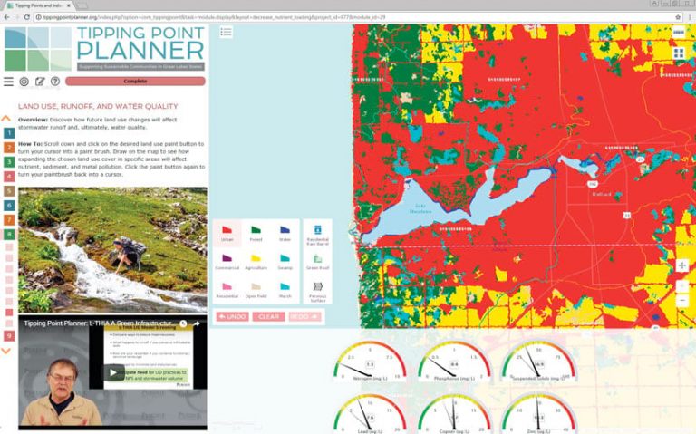
The result of this partnership is the Tipping Point Planner Program, a facilitated workshop designed around a collaborative, web-based decision support tool that provides communities with information about local land use and watersheds in various multimedia formats. The interactive modules help participants do four things:
- Evaluate natural resource assets.
- Prioritize community goals.
- Assess past and potential future changes by displaying maps and gauges that indicate tipping point status.
- Explore what-if scenarios with real-time models.
At the end, the Tipping Point Planner generates an action plan that brings together these four items in a PDF, which contains maps, charts, and planning priorities.
GIS Supports the Science Behind the Decision-Making Tool
In this context, a tipping point is when an ecosystem shifts from a healthy state to an unhealthy state. A watershed in a healthy state typically contains a vibrant community of native fish species in clean water. When a watershed transitions from a healthy state to an unhealthy state, it is usually indicated by the mixture of native and invasive fish species in water that has potentially harmful algal blooms.
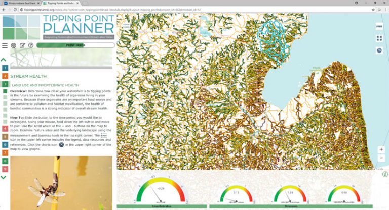
In Tipping Point Planner workshops, participants get to evaluate how proposed land-use changes may affect water quality in their communities. The online decision support tool integrates a variety of spatial models. These include Purdue University’s land-use forecast tool, called Land Transformation Model (LTM); water quality tools such as Purdue’s Long-Term Hydrologic Impact Analysis (L-THIA) model and the US Geological Survey’s (USGS) SPARROW (Spatially Referenced Regression on Watershed) model; and the University of Michigan’s land-use biotic tipping point model, which provides users with the status of nutrients, sediments, fish, and aquatic insects in streams. Incorporating separate models like this enables planners to analyze a range of plans over a period of two to five decades.
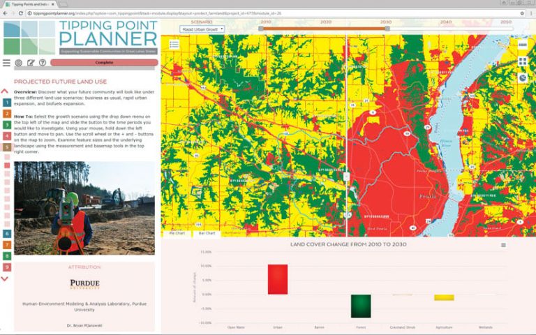
Additionally, the Tipping Point Planner’s GIS-based tools enable users to visualize the results of the models on a map. Users can zoom in and out and pan across the map to see stream quality ratings at different spatial scales (e.g., local versus regional). The team also employed the National Hydrography Dataset alongside land-use classification to generate a seamless network of stream reaches and elevation-based catchments, which allows users to see how land drains into specific rivers or streams. And topical pages, which show things like how to decrease nutrients or protect farmland, are modeled after ArcGIS StoryMaps, with a narrative pane on the left that guides users through the decision support tool and a main stage on the right where users interact with the map, data, and graphs.
The Tipping Point Planner in Action
Many cities in the Great Lakes region need to improve their water quality. In Peoria, Illinois, for example, water surge from storms and melting snow often exceed the capacity of existing storm water infrastructure, which results in sewer overflow and other excess nutrients polluting the Illinois River. Like a lot of other communities, this has afflicted Peoria for years—to the point that both the United States and the Illinois Environmental Protection Agencies (EPAs) have mandated that the city develop a plan to address the problem.
The City of Peoria and its innovation team organized a Tipping Point Planner Program workshop to explore solutions. An extension specialist from Purdue held an initial discussion with community leaders about their specific watershed problems, goals, and community engagement options. This person also conducted a series of workshops that brought in Tipping Point Planning team members who have specialties in community planning, GIS, public engagement, biology, and landscape modeling.
“Peoria has an issue they’re trying to resolve before they cross the tipping point, and there are very costly solutions to it, but we’re helping them explore alternatives that are less costly and would provide other environmental benefits as well,” said Bernie Engel, professor of agricultural and biological engineering and associate dean of agricultural research and graduate education at Purdue University, who is leading the Peoria project.
The Tipping Point Planner Program helped Peoria’s innovation team figure out not only what environmental variables needed attention but also how to choose from a host of solutions presented to them based on model simulations of anticipated nutrient reductions and the costs of various remediation options. Using the decision support tool and a specific sewer flow model developed by Purdue’s agricultural and biological engineering department, the City of Peoria got the guidance it needed to settle on a green infrastructure-based plan to address its sewer overflow problem. The plan, which the city is moving forward with, focuses on reducing impervious surface areas such as pavement and incorporating more porous surfaces into the community in the form of parks and open spaces.
Discovering Tipping Points Before They Can Occur
Other communities are benefiting from the Tipping Point Planner Program as well.
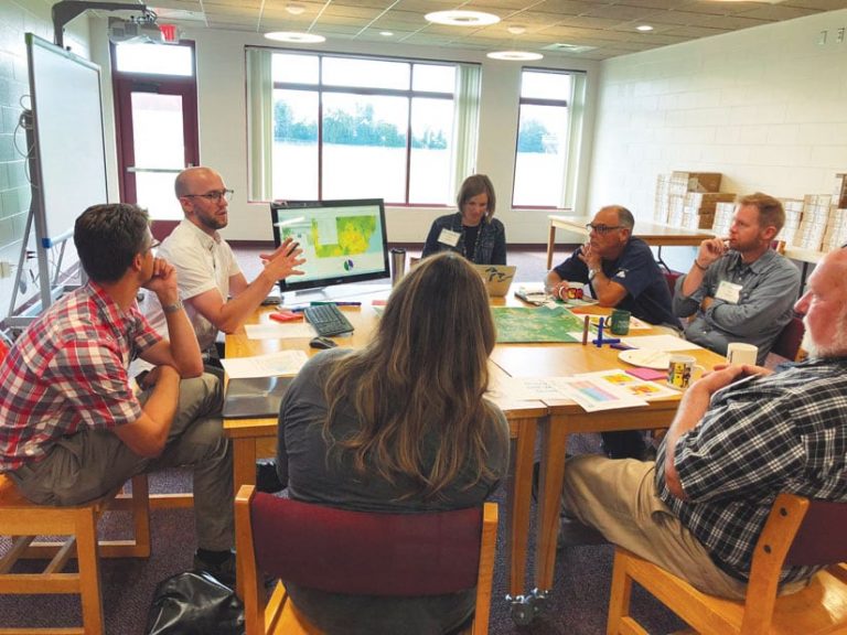
To address the future of two watersheds near Saginaw Bay in Lake Huron—the Au Gres River watershed and the East Branch Au Gres watershed—two Tipping Point Planning team partner organizations, Michigan Sea Grant and Huron Pines, hosted a Tipping Point Planner workshop at Au Gres High School in July 2018. Over two days, community leaders, citizens, city planners, and natural resource professionals from the Saginaw Bay area took part in scientist-led group sessions and used interactive tools to explore three topics: green infrastructure, open space modeling, and nutrient modeling.
Workshop participants ended up finding out that their watersheds are in great condition but that they lack a plan to protect these largely unadulterated landscapes. Using the Tipping Point Planner modules, attendees identified priority areas for conservation.
Following the workshop, participants had access to the decision support tool and worked on generating a finalized action plan. A month later, the Tipping Point Planning team hosted a follow-up workshop with the partner organizations to support their action planning efforts.
Technology Expands to Support an Evolving Project
As it becomes more common to use spatial models in the planning process, it is more important than ever to provide users with a variety of model outputs online—something the Tipping Point Planning team is already doing and will continue to develop. This allows scientists and specialists to process more data using more sophisticated methods. And using an online platform could serve as a near real-time utility for the planning process in the future.
For more information on the Tipping Point Planner Program, email the project extension lead, Kara Salazar, at salazark@purdue.edu. For questions regarding the use of ArcGIS technology or any of the scientific work that supports the Tipping Point Planner Program, contact Purdue professor Bryan Pijanowski at bpijanow@purdue.edu.


