This is the story of how the manager of a small city in West Virginia came up with a big idea: convert the city council agenda from a drab document to a lively account of municipal business using an Esri Story Maps app.
The agenda is a tried and true document that guides city council meetings. It lists items up for discussion or vote. Typically written in a bureaucratic style and void of visuals, the agenda is often posted as a PDF on a city government’s website.
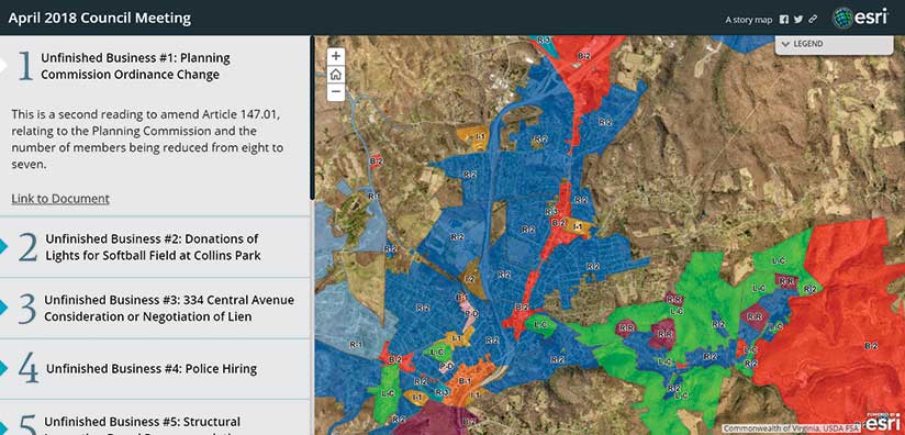
That’s no longer true in Oak Hill, West Virginia, where the city council replaced a static agenda with an animated story map to guide its monthly meetings. Using the Esri Story Map Series app, the city’s lone GIS employee Marvin Davis creates an itemized, interactive agenda describing each item and providing maps, photographs, and links to documents such as reports, legal notices, and correspondence.
Oak Hill is a city of 8,500 people that lies just west of the New River Gorge National River, a 70,000-acre national park. Earlier this year, Esri account manager Daniel Peters showed city manager Bill Hannabass an Esri story map and he immediately thought, “Gosh, I could use that for the council presentation. It’s visual.”
Hannabass used maps to view assets when he served in the US Army. “I lived and died by maps,” as he remembers it. He was naturally drawn to the ability of maps to tell a story visually and tell it quickly. He was also impressed that the cloud-based interactive maps from the city’s ArcGIS Online organization account could be used in story maps. Esri Story Maps apps are currently available at no additional cost to ArcGIS Online account holders like the City of Oak Hill.
Davis, the GIS coordinator, was given the task of turning the monthly city council agenda into a story map. Davis selected the Story Map Series app with the side accordion layout. Because that layout automatically builds a numbered list of items that run down the left side of the story map, Davis just writes a short header and one line of text that describes each agenda item; adds a related map or a photo; and then creates links to any other images, legal documents, notices, or correspondence.
One agenda item Davis worked on for the April city council meeting dealt with structural inspection board recommendations on several buildings around town that needed to be repaired or demolished. Davis mapped the buildings’ locations in the story map and added links to images of those structures and related documents such as demolition orders and bids. “It makes [the agenda] informative,” Davis said. He said the story map format gives those looking at the agenda the geographic context of the issue, and all the information on it is at their fingertips.
Oak Hill City Council members and local media outlets receive story map agendas in a ShareFile packet that Hannabass sends in an email prior to meetings. During the city council meetings, Hannabass also goes through each numbered item on the story map agenda, which is displayed on two screens in City Hall.
Agenda items often have geographic reference points, so Hannabass said using a story map as an agenda makes it easy for him to answer questions if one comes up. “If there are four dilapidated structures that I have to tear down and someone asks [about a particular building], ‘What street is that one on?’, I can pull up a map,” Hannabass said.
Because photos and legal or other types of documents can be linked in the story map, those are easy to access and view, too, if necessary. No longer does Hannabass need to display the agenda as a Microsoft Word document or PowerPoint presentation. Gone are the PDFs or scanned images of maps. If anyone asks him a question, Hannabass has “a ton of information” to dig into. “You don’t have a ton of boring PDFs to flip through.”
Hannabass said online story maps are an excellent medium for sharing information to a city council, board of directors, or other group—public or private. People are often overwhelmed by reams of paper they receive before a meeting. “Our council packets were three to five inches thick,” Hannabass said. “It is crazy to have that much paperwork.”
He put an end to paper-based agendas in Oak Hill some time ago. According to Davis, Hannabass has been a strong advocate for a municipal GIS. He brought Davis on board as GIS coordinator and recently helped negotiate an enterprise license agreement between the city and Esri.
That agreement, scheduled to begin in July 2018, will increase the number of city employees with access to GIS and beef up capabilities to do analysis. “Hannabass has been my biggest champion here,” Davis said.
The city also plans to share the city council story map agendas online with the public soon, making it easier for Oak Hill residents to stay informed about what’s happening in their community. Right now, city council members and the media can study the city council agenda plus all the related documents in one online app before meetings begin.
“That is transparency that is beyond what is typical,” Hannabass said. “It [will] be more transparent on the website.”
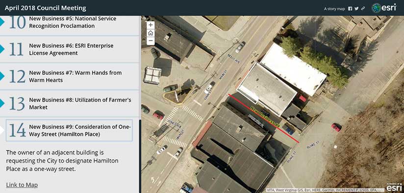
Davis said that there’s often a geographic component to city business, which is why sharing information via a story map agenda makes perfect sense. If viewers want to take a closer look, for example, at zoning designations or a proposed new one-way street on a story map, they can just pan around and zoom in on the geographic locations. A PDF or a scanned image of a map restricts their view.
“I am biased,” said Davis, referring to his interest in geography and his job in GIS. “But I think [the story map agenda] offers a more informed view. You are able to look at pertinent documentation and a map.”
Since Esri released the first Esri Story Maps app in 2014, people around the world have built more than 600,000 story maps. Oak Hill’s story map designed specifically for city council agendas seems to be a first. The city’s adoption of the Story Map Series app to produce the agendas impressed Allen Carroll, who leads the Esri Story Maps team and is program manager of storytelling.
“We’re always thrilled to see fresh and unexpected new uses of Esri Story Maps,” Carroll said. “Oak Hill’s use of our Story Map Series app to present its council agenda is a delightful example of the versatility and power of map-based storytelling.”