Want to apply GIS to meet organizational challenges and improve operations but find that workload pressures and limited staff make this difficult? Save yourself unnecessary effort and get proven results with ArcGIS Solutions
This collection of free and fully supported templates that configure ArcGIS to perform specific tasks and optimize workflows will save you time. The templates solve common problems and implement workflows for a specific industry, so you can focus on the problems that are unique to your organization. Using templates will give you those quick wins that sell GIS to leadership and help align your organization’s GIS with its strategic business needs.
Because ArcGIS Solutions are supported by Esri, they are sustainable. Templates are updated to work with new software releases so you avoid being trapped by legacy technology. This also means you can contact Esri Technical Support with questions. Esri Professional Services can help you quickly configure and deploy solutions. Many of Esri’s partners offer complementary applications that extend solutions and can help with deployment.
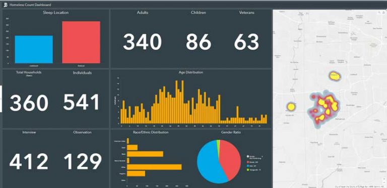
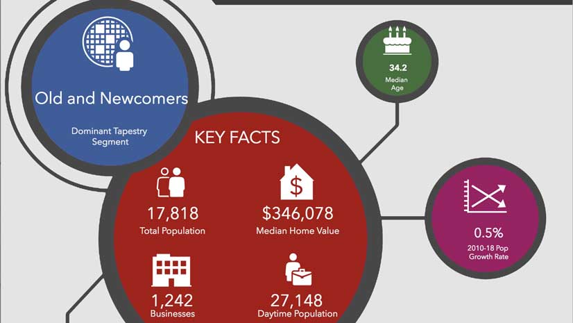
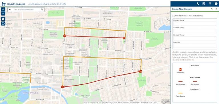
Each template incorporates the maps, apps, and tools with the functionality needed to accomplish a specific workflow. ArcGIS Solutions address the specific needs of local government, state government, emergency management, defense, intelligence, business, gas, electricity, water, and telecommunications. For example, under Local Government solutions, the subcategory for law enforcement has Opioid Response Dashboard and Road Closures templates.
Each solution provides an explanation of how it is used, its requirements, and release notes, and some have a sample you can try out. Deployment can be simplified by using the ArcGIS Solutions Deployment tool, but manual deployment is documented for each solution as well.
The gallery of solutions makes it easy to locate the solutions you need. Communities have grown around ArcGIS Solutions for each industry. Links to the GeoNet group, any related blogs, videos, ArcGIS Ideas suggestions, GitHub repositories, or Twitter accounts can be accessed from the Community page of the ArcGIS Solutions website. Through these communities, you can leverage collective knowledge of best practices and industry expertise.
See how ArcGIS Solutions can help you get more done without doing more.