The City of Aspen, Colorado, is a world-famous ski resort and a vacation spot for celebrities. Aspen’s GIS team has been working to make its enterprise GIS more accessible to users.
Led by GIS program manager Bridgette Kelly, the three-person team (including Kelly) is responsible for developing and maintaining the city’s GIS platform and applications. While the team is located in the engineering department, it supports all departments.
Aspen has a Small Government Enterprise Agreement and is a member of the Esri Advantage Program. Citywide, there are about a dozen individuals in other departments who use ArcGIS for their work. More than 200 city staff are light users, who consume GIS content.
Until recently, the GIS team was also fielding requests for maps and data from community members. To manage these requests, Kelly’s team used a fee-for-service model for both internal staff and the public.
“They would call us up, request something, we’d take their payment, and then send [the GIS product] out. We realized that wasn’t efficient for either side,” said Kelly.
A new GIS delivery model was needed.
Embracing the Portal Paradigm
The team decided to replace fee-for-service delivery with a self-service environment.
As Kelly explained, “Because our GIS program is very small, we knew that we wanted to enable all of our users within the city to utilize the GIS resources themselves instead of calling us.”
To facilitate easy access to the city’s GIS maps and data, Kelly’s team launched an ArcGIS Hub open data site called Map Aspen. Kelly, with team members Joshua Zeeb, a GIS analyst, and Rachel Eyler, GIS project assistant, provide GIS resources to the public through the site. These resources include imagery, transportation and zoning data, 3D basemaps, and web maps and web apps. Site users can download data and create and print their own maps. The site is popular with developers as well as community members.
To support the GIS needs of internal staff, the team leveraged ArcGIS Enterprise. In 2019, the team used Advantage Program credits to engage Esri Services experts and launched an enterprise portal website to share useful GIS resources.
Enabling Self-Service GIS
With the city’s enterprise portal website operational and populated with resources, it was time to engage city staff.
“Once we put up the GIS portal, we needed to start getting people in there and getting trained,” said Kelly.
Initially, the team recommended that staff take Esri’s free web course for new ArcGIS Online users. That course introduces high-level portal concepts that are also relevant to ArcGIS Enterprise users. However, this course wasn’t a perfect solution for all city staff.
Aspen’s users were working with sample datasets and portal tools and workflows in ArcGIS Online that didn’t quite match those in the city’s portal. While talking with Esri training consultant Tosca Hoffman, Kelly learned that Training Services could tailor the ArcGIS Online web course specific to the experience that Aspen’s enterprise GIS portal users have.
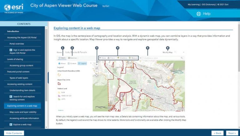
Kelly immediately saw the value of that option. “We wanted to have a customized experience where our users were entering our portal, utilizing our content, and using our workflows in order to learn the technology,” Kelly said. “So, we came up with a custom course that did just that.”
Kelly used Advantage Program credits to commission the custom web course. From inception to delivery, the project took five months. The course is hosted on Esri Academy (esri.com/training) but visible only to Aspen staff.
Course exercises are designed so that staff directly access and navigate through the GIS portal content. When an individual accesses the portal for the first time, their portal user account and profile are automatically created. The user profile defines the user type and privileges. By default, all new users are viewers. With a portal account and privileges, staff can complete the training and get comfortable using the portal to support their work.
Forging an Adoption Strategy
Launching the portal and providing effective training were key elements to establishing a citywide self-service environment for GIS, but Kelly realized more needed to be done.
Department staff were used to coming to her team for GIS support. Seeking out GIS information on their own would require shifting from these entrenched habits. During their Advantage Program annual planning meeting, Kelly and Zeeb learned about Esri’s people-focused change management practice. They attended the Preparing for Change workshop. Change management consultants Lyndal Brookhart and Chris Vokaty taught that workshop. It emphasized the importance of sponsorship and communication to successful change initiatives.
The concepts resonated with Kelly, who felt that Aspen’s department heads might be unaware of all the support the GIS team provides to their staff. To ensure sustained adoption of the self-service portal, the GIS team would need leadership’s support. After the workshop, Kelly used Advantage Program credits to retain Brookhart for one-on-one consulting. The two focused on a strategy to gain sponsorship.
Kelly leveraged Brookhart’s communication expertise in developing a presentation she delivered to city leaders that highlighted how GIS work was directly supporting the city’s strategic goals and solving problems for each department. She also shared how GIS drives better customer service and other benefits to the community. Kelly’s strategic focus was well received by leaders. Building on that success, she and Brookhart mapped out a four-phase adoption strategy dubbed the GIS User Expansion campaign. The campaign has Learn, Explore, Leverage, and Innovate phases.
For the first two phases of the strategy, Learn and Explore, the GIS team focused on raising awareness and participation across city departments. “We wanted it to be fun,” Kelly said. Prizes were offered and a pizza party given for the department with the most new portal users.
The strategy has worked. With more than 200 active members, the Aspen GIS Portal is supporting staff GIS needs as Kelly hoped it would. New users are happy when they discover all the portal resources available to them.
“I don’t think a lot of people realized how much content is in there,” said Kelly. “They love that they can get in there and get the information to answer community member questions without bringing it to us.”

Freed Up for Priority Projects
The third phase, Leverage, will focus on encouraging users to create their own GIS content in the portal. To help with that, a second custom web course will train users how to make web maps and apps. Like the first course, this one will be tailored to Aspen’s enterprise GIS portal and content shared there.
Details of the final phase, Innovate, are still being planned, but Kelly would like to establish a GIS “superuser” point of contact in each department. “These users would have the necessary skills to take the platform to the next level by incorporating analytics into their projects,” she said. The insights produced by superusers would support data-driven decisions across the city.
With the growth in portal adoption, Kelly, Zeeb, and Eyler have more time for projects that leverage more advanced GIS capabilities themselves. Eyler created a 3D basemap of the city, which is used for visualization and analysis support.
The team also focuses its work on priorities defined by Aspen’s city council that include transportation and climate action. To support those priorities, Zeeb conducted an analysis of the city’s electric vehicle (EV) infrastructure.
“We created an [ArcGIS] Insights page with parking transaction data and EV charging transaction data,” said Zeeb. “We used it to create an analysis and provide insight into EV viability and usage within the city, mainly built upon the idea that EV usage and production will only increase, so how can we keep up with it?”
Aspen’s Clean River Program to reduce pollution in stormwater runoff from developed areas is managed by the engineering department. The GIS team is helping share information on actions that the city and residents can take to decrease pollution.
“We want to help [them] understand not only our stormwater infrastructure, but many of the policies, projects, and programs that will help improve the health of our river,” said Kelly.
With the successful launch of their self-service GIS delivery model, the team of three is poised to make an even bigger impact with GIS-driven location intelligence.
For more information on the City of Aspen’s self-service GIS initiative, contact
gis@cityofaspen.com.