Esri Named Leader in Understanding Climate Risk
Independent research firm Forrester recognized Esri as a leader in offering advanced data processing and visualization to help decision-makers tackle climate risks in its report, The Forrester New Wave: Climate Risk Analytics, Q4 2022. Esri received a differentiated rating—the highest score possible—in 9 out of 10 criteria, including advanced data processing, visualization, and threat modeling. The report notes, “If you have physical assets that could be threatened by climate, Esri can bring the data and processes to bear to target operational resiliency opportunities.”
Scalable Geospatial Analysis in a Data Science Workflow
ArcGIS GeoAnalytics Engine can be plugged into Databricks architecture to extend cloud-based geospatial capabilities for organizations that need big data spatial solutions at speed and scale. This engine is a plug-in for Apache Spark that extends data frames with very fast spatial processing and analytics and is ready to run in Databricks. ArcGIS GeoAnalytics Engine allows data scientists, engineers, and analysts to analyze geospatial data within their existing big data analysis environments. To read more about these use cases, see https://bit.ly/3BxySkG.
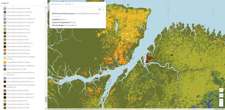
World Terrestrial Ecosystems Map Released
In partnership with Esri and The Nature Conservancy, the US Geological Survey (USGS) launched the World Terrestrial Ecosystems Map, which breaks up the globe not by political boundaries but instead by areas of similar climate, landform, and land cover. “Ecosystems give us goods and services like food, water, [and] fuel…so we need to take care of them,” said Dr. Roger Sayre, senior scientist for ecosystems at USGS and the lead on the project. “A requirement for managing ecosystems is first knowing what they are and where they are on the planet. That’s why we classify and map ecosystems.” The map—which is available in ArcGIS Living Atlas of the World and as an explorer tool at rmgsc.cr.usgs.gov/wtee—can be used for conservation planning, analyzing ecosystem health and resilience, formulating how to make progress toward achieving the United Nations Sustainable Development Goals (SDGs), and more.
GeoAI Helps Develop Sustainable Agriculture in Africa
To aid government and nonprofit organizations in Africa in addressing acute challenges related to climate change, including low agricultural yields and heavily degraded soils, Esri is collaborating with Microsoft to develop GIS-based crop mapping and land management technology. The tools combine Esri’s geospatial artificial intelligence (GeoAI) capabilities with satellite imagery and Microsoft’s infrastructure and AI devices to provide deeper understanding of the agricultural landscape across the continent.
There is a great need to improve agricultural productivity in Africa. Combining Esri’s GeoAI capabilities and satellite imagery, as well as Microsoft’s infrastructure and AI devices, will help build a deeper understanding of the current agricultural landscape, enable closer monitoring of crop conditions throughout the growing season, and suppport the mitigation of climate change impacts. This will contribute to better production and food security. To learn more about how location intelligence can power global land monitoring, visit https://bit.ly/3VUlM95.

Esri Extends Its Collaboration with Geneva Demining Center
Removing land mines and other explosive ordnance from former war zones is an inherently geographic problem. Humanitarian organizations that perform demining are relying increasingly on digital technology, especially GIS, to support these endeavors. Esri and the Geneva International Centre for Humanitarian Demining (GICHD) have renewed and expanded their partnership through a memorandum of understanding (MOU).
Humanitarian organizations, which have been using GIS for more than two decades, will continue using Esri’s technology to map explosive ordnance to more precisely clear it and ultimately help people return to their homes and use their land safely. Esri will support modernization of the Information Management System for Mine Action (IMSMA), the GICHD flagship platform, used by more than 80 percent of national and United Nations mine action programs globally.
Built using Esri’s GIS software, the platform serves a critical purpose in the demining process by providing information access to a wide range of stakeholders, as well as real-time visualization and reports on the extent of contamination in specific locations. To learn more about how GIS tools can help humanitarian organizations, visit esri.com/en-us/industries/humanitarian/overview.