Unlocking the hidden potential of urban environments
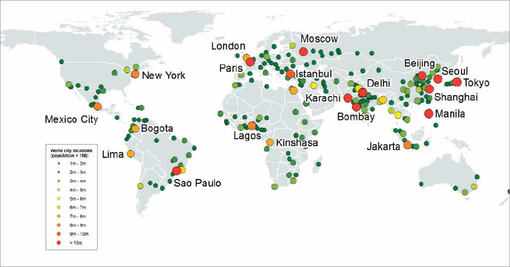
The world’s population is becoming more urbanized, which means creating sustainable urban environments is increasingly important. The current design of urban environments has huge potential to benefit from urban retrofit that would achieve more sustainable outcomes.
The project described here focuses on implementing active transport infrastructure within the urban environment to reduce the reliance on private vehicles. The analysis processes used in this project can easily be applied to other aspects of urban retrofit.
Project Context
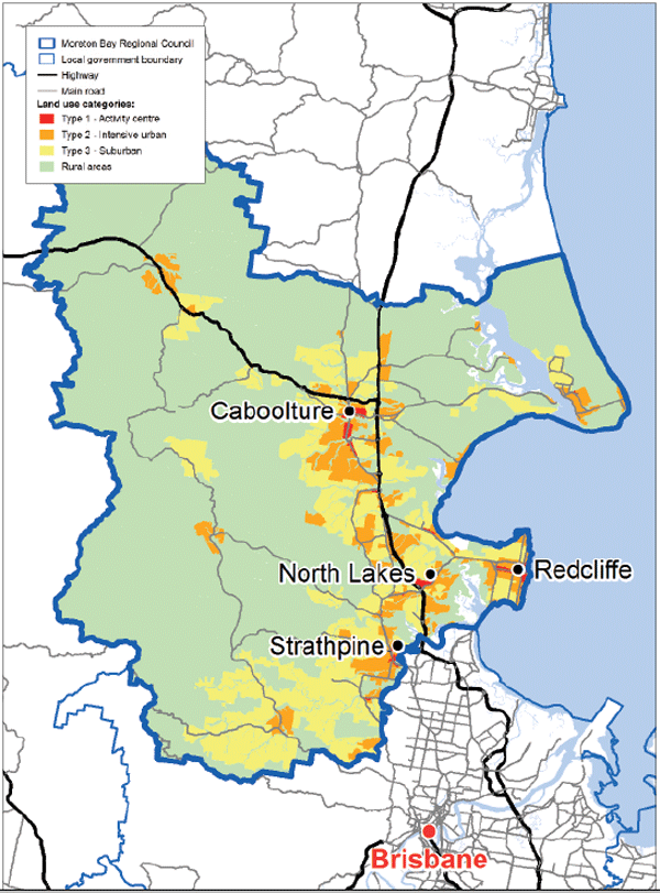
The Moreton Bay Regional Council (MBRC), a local government area in Queensland located north of Brisbane, is Australia’s third-largest council, with an area of 206,944 hectares (ha), or 511,369 acres. With approximately 400,000 people (per 2011 Censuses of Population and Housing), it also has one of the fastest-growing populations in Australia. The MBRC population is estimated to grow to 516,000 people in 2031.
The MBRC Community Plan 2011–2021 states, “By 2021, our region will consist of well-connected places and residents will embrace more sustainable travel and behaviour.” In line with the MBRC community plan, the council wants to target investment in active transport (walking and cycling).
Implementing a high-quality infrastructure network encourages local residents to become more active. Encouraging active transport modes will also help achieve the council’s wider objective of creating well-connected and vibrant local neighborhoods and moving away from typical suburban and urban sprawl.
Previous investment focused on road capacity infrastructure. However, the more holistic approach now being applied focuses on active transport. Consequently, MBRC embarked on a project to quantify and prioritize the upgrades required to the network to achieve this objective in the community plan. This project, the Moreton Bay Network and Corridor Study, ran from April 2012 until June 2013 and focused on the main road network encompassing all arterial, subarterial, and collector roads. These roads have a combined length of almost 1,200 kilometers (km) (or about 730 miles).
This led to a couple of questions. How do you assess the existing condition of the active transport networks? How do you then prioritize these upgrades to provide the best value to the community?
The answers to these questions required considering which was the best approach to upgrading the network to meet the council’s standards while taking into account the finite financial resources available. To assess and prioritize its active transport network upgrades, MBRC partnered with Arup Group Limited, an independent firm of designers, planners, engineers, consultants, and technical specialists. Because of its powerful analysis capability, GIS was chosen as the platform to complete this project.
The Analysis Process
Active transport infrastructure consists of facilities for walking and cycling. The individual elements include footpaths (pedestrian only or shared), pedestrian crossings, street vegetation, and cycle lanes. The analysis identified gaps in the active transport network and explored the potential for new infrastructure based on available space in the road reserve.
The project also evaluated existing active transport infrastructure against MBRC standards to determine where the existing network required upgrading. Finally, when looking to prioritize upgrade works, the surrounding land use, road hierarchy, and proximity to nodes such as commercial centers and community facilities were included to ensure that funding was being invested in the right areas.
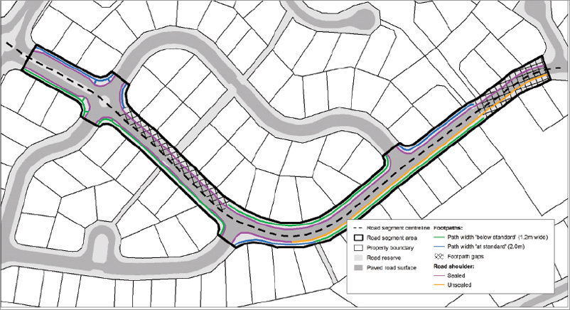
Combining these elements was a complex undertaking. Without the use of GIS, it would have been time-consuming to go through each road segment manually. With GIS, the project team could process all active transport elements and produce results in a timely manner.
This project was divided into three main phases:
- Network audit
- Gaps analysis (based on agreed standards)
- Upgrade prioritization
Network Audit
The first step in determining the required upgrades of the active transport network was to audit the existing network. This involved dividing the road network into 1,690 individual segments. Using the road reserve polygons in the cadastral database, each road segment was given an area. All features within this area were classified as part of that road segment. Features outside the road reserve were excluded.
Once the segments and extents were determined, the network audit calculations gave summary figures for the existing network. Using the Analysis Tools geoprocessing tools in ArcGIS Toolbox, the active transport networks were documented for each road segment. This resulted in 80 separate attributes that documented the active transport network for each of the 1,690 road segments. For each road segment, all 189 attribute values were collated or calculated to create a comprehensive database of information on the active transport network for the Moreton Bay Region. Creating this database provided the basis for performing the network analysis.
Gap Analysis
When identifying potential deficiencies in the active transport network, the desired level of service needed to be determined. MBRC and Arup held a workshop that produced a clear set of guidelines for all elements of the active transport network.
To create realistic standards, urban land uses were divided into three categories: type 1 (activity centers), type 2 (intensive urban), and type 3 (suburban). Standards were developed for each category. This step allowed the analysis to produce realistic results based on the intensity of the land use.
The gap analysis involved comparing the results of the network audit with the desired standards to determine the quantity of each active transport element. Areas were classified as follows: those that met the standards were deemed at standard, those with active transport elements that did not comply with standards were classified as below standard, and those with no active transport infrastructure were deemed deficient.
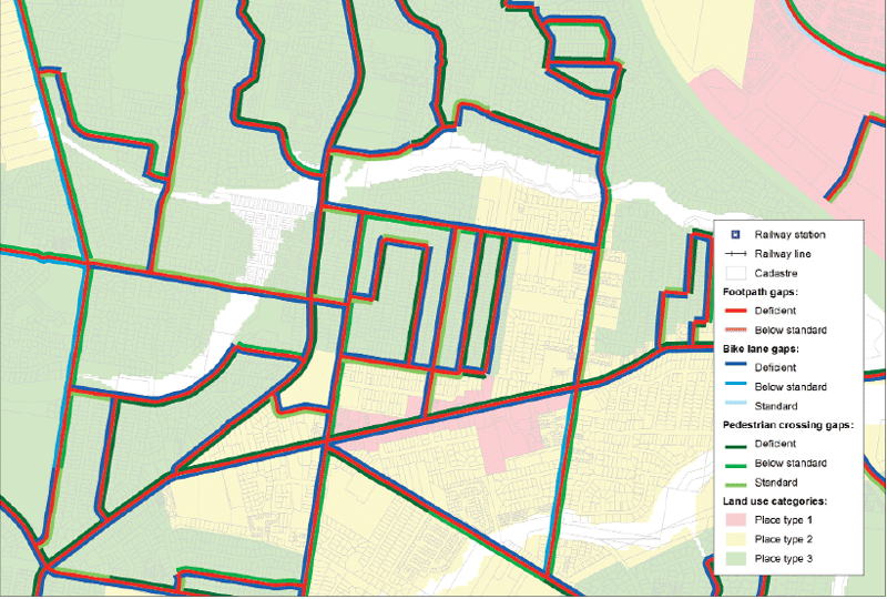
The results revealed that most of the active transport network would benefit from upgrading. The active transport facility benchmarks set for desired levels of service would ultimately create a more active and connected community.
Upgrade Prioritization
After comparing the existing active transport network to the standards, the final step was to prioritize the network upgrade to ensure the funds spent would provide the most benefit to the community. To do this, upgrades for these deficiencies were divided into two categories: short term and longer term. Within the road reserve, existing conditions play a key role in what is possible. Each road segment was evaluated to determine if upgrading the active transport network was an easier short-term task or a complex and longer-term project.
Study results were fed into MBRC’s new Priority Infrastructure Plan (PIP), which manages the direction of infrastructure investment in the region until 2031. It divides the MBRC area into 21 priority areas for investment allocation. To provide more detail, each priority area is further divided by the three land-use categories to create 57 separate areas.
All the active transport network data was aggregated by these 57 areas to give a summary of active transport infrastructure provision. As well as documenting the level of service, unit costs were applied to give MBRC cost estimates for upgrading the network within each priority area. This information allowed MBRC to prioritize resource allocations based on where the need was greatest. Because the base data for each road segment was available, a more detailed approach could have been taken. Prioritizing upgrades for individual road segments could be based on the current level of infrastructure provision, whether it was in an area of short- versus longer-term upgrades, surrounding land use, and proximity to key destinations and public transport nodes.
Implementation of Analysis
Road reserves account for a significant amount of land. However, the traditional urban fabric doesn’t make adequate use of these areas. In the MBRC region, unpaved areas of the road reserve (i.e., portions of the road reserve not covered by the actual roadway) account for 3.75 percent of the total land area. This equates to approximately 7,750 ha (~19,000 acres). This is a substantial amount of land and could provide significant benefits to the community and environment if used effectively.
In addition to implementing active transport infrastructure and facilities, road reserves could be used for environmental features such as biofiltration beds, garden beds, and fauna crossing facilities.
Biofiltration beds improve the quality of storm water runoff. These beds use plants, garden beds, and the soil profile to naturally filter physical, chemical, and biological contaminants from storm water runoff. This results in significantly cleaner runoff flows and healthier waterways.
Garden beds and vegetation can provide urban habitat for fauna. Installing gardens with local plant species provides shelter and food for local animal species, and vegetation can contribute to the amenity of the road corridor by providing shade for pedestrians and cyclists, helping keep the otherwise hot urban environment cooler and maintaining the connection of green spaces.
Implementing fauna crossing facilities would help animals navigate through urban environments to maintain important linkages between habitat areas that would otherwise be cut off by urban development.
Road reserve areas could also be used to improve the usability of urban areas with the provision of street furniture such as benches, bike racks, drinking fountains, bins, and awnings. Adding acoustic and visual barriers that mitigate against adverse conditions of surrounding activities would improve the aesthetics of these areas for residents.
Around public transport nodes, road reserve space could contain facilities that support public transport services such as public safety and shelter facilities, storage facilities, and interfaces with other types of transport to make public transport more attractive to prospective users and increase patronage.
A Business Case
In addition to environmental benefits, investing in public urban spaces can have financial benefits. Investing in active transport networks has the potential to change people’s transportation choices.
Moving to more active transport can have a beneficial effect on the health of local communities and reduce spending on health care.
Creating a comprehensive active transport network can reduce private vehicle trips. Along with investing in public transport facilities to increase patronage, this can reduce investments in road capacity upgrades, especially to handle peak-hour commuter travel in areas where road networks are at or near full capacity. Finally, investment in urban areas can contribute to raising property values.
An urban retrofit project is a large undertaking but it can create many economic opportunities for local businesses and employment opportunities for local residents. When these scenarios are considered in the long term, their return on investment in urban areas can be significant for both the public and private sectors.
Summary
Historically, urban areas have been designed to separate people from the surrounding natural environment. This goal needs to be reconsidered. Existing urban areas need to be retrofitted so they are more in line with natural environmental systems.
Significant work has been done to make individual buildings more sustainable, but there is a need for a holistic citywide approach to making urban areas more sustainable. Conducting this type of spatial analysis will give urban planners and elected officials the information they need to make the big decisions that will improve cities. Using GIS in this way can access the potential for retrofitting urban areas and take the idea of sustainable urban development from concept to reality.
For more information, contact Greg King (greg.king@arup.com, g_king@tpg.com.au).

