For cities that receive significant snow, removing it from streets in a consistent and timely manner is important to the safety of residents and the economic well-being of businesses. The City of New York employs GIS and live feeds to provide near real-time situational awareness to manage snow removal activities.
While everyone is enjoying summer, the New York City Department of Sanitation (DSNY) is thinking about winter. DSNY is the world’s largest sanitation department, and it is responsible for keeping New York City healthy, safe, and clean.
Besides collecting more than 10,500 tons of residential and institutional garbage and 1,760 tons of recyclables each day, DSNY cleans up street litter and vacant lots and is committed to the zero waste to landfill initiative. [New York City’s Zero Waste initiative aims to reduce the amount of material sent to landfills by 90 percent by 2030, with an eventual goal of eliminating the use of landfills through waste reduction, wastewater treatment, and reuse and recycling programs.]
During wintertime, DSNY is responsible for snow removal on 19,000 lane miles of roadways. The Operations Management Division (OMD) of DSNY monitors the progress of snow removal operations. Previously, operations were mostly paper based. Routes were saved in word processing documents, printed out, and assigned to field crews.
With more than 1,800 snow removal routes to run, the task of efficiently maintaining them became a challenge. In 2014, the Enterprise Geospatial Program Management Office (EGPMO) was established within OMD to add geospatial data management and analytics capabilities to the agency. EGPMO began working with other DSNY divisions, city agencies, and vendors to quickly create GIS tracking and analytic tools to gain situational awareness during snow removal operations.
Tracking Snow Removal
DSNY has a snow removal fleet of more than 2,000 collection trucks converted to snowplows, and more than 700 salt spreaders. These assets are equipped with GPS devices so their locations can be tracked during snow removal operations. The GPS pings are snapped to the nearest Citywide Street Centerline (CSCL) segments, the city’s official GIS street network dataset, which is maintained by the New York City’s Department of Information Technology & Telecommunications (DoITT) and Department of City Planning (DCP).
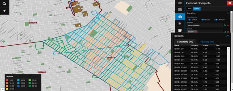
The traversed CSCL segments allow DSNY to accurately track and report completion percentages. They also provide locations of missed segments, where DSNY can quickly deploy the proper resources for those missed streets. The operation progress is displayed in an internal GIS web mapping application called Bladerunner, which was built using Esri technology. OMD worked closely with DSNY’s Bureau of Information Technology (BIT) and Critigen, an Esri partner, in developing the first version of the Bladerunner application. Using the ArcGIS Server web service protocol and the ArcGIS GeoEvent Server licensing role, Bladerunner can display, process, and analyze automated vehicle location (AVL) pings from snow removal vehicles in near real time.
To promote public transparency, DSNY and DoITT also publish PlowNYC, a public-facing web mapping application that allows members of the public to know their street’s snow priority designation and monitor snow removal progress. The application is updated every 15 minutes during a snowstorm, with progress updates based on the AVL tracking. PlowNYC was originally hosted by DoITT. Beginning with the 2020–2021 snow season, responsibility for maintaining and hosting PlowNYC shifted from DoITT to DSNY and Rastrac. Rastrac collects and processes raw GPS pings to link each point to a specific CSCL segment. It also generates last serviced information for each block that is displayed in PlowNYC.
Tracking Snow Complaints
In addition to AVL tracking, DSNY also tracks problem areas using the city’s 3-1-1 system. Operational since 2003, New York City’s 3-1-1 system provides government information and nonemergency services to residents. New Yorkers can also report snow-related complaints or request services through the 3-1-1 system. These calls are logged and geocoded, based on the addresses or locations given.
These geocoded locations are invaluable to operations. Using near real-time 3-1-1 data, EGPMO created an internal Esri operations dashboard within its ArcGIS Enterprise portal. The 3-1-1 data goes through several automated geoprocessing steps to add customized DSNY operational fields for the dashboard. The operations dashboard provides interactive web maps, charts, and quick metrics that give insights into the who, what, when, and where of the reported issues. DSNY then provides the how to deploy the proper resources to investigate and mitigate those complaints. The application can be filtered by date and time, district, and/or complaint status for more detailed neighborhood information.
Enhanced Situational Awareness
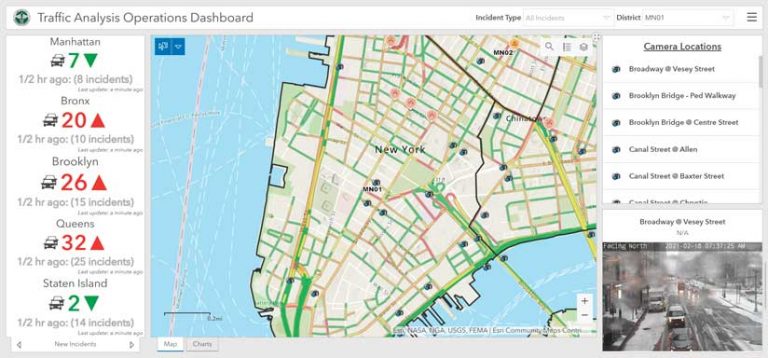
Waze traffic data is another crowdsourcing tool for gaining situational awareness during snow events. Waze Live Alerts Layer, provided by Waze through the ArcGIS Marketplace, shows locations of traffic issues reported by the many users of the Waze app. These users include drivers and riders throughout the city as well as map editors.
Overlaying this live point feature layer with Esri’s World Traffic Service layer, along with live feeds of more than 700 closed-circuit traffic cameras maintained by various regional transportation authorities—New York City Department of Transportation, New York State Department of Transportation, New York State Thruway Authority, and Metropolitan Transportation Authority—gives DSNY a better understanding of current traffic situations.
Putting all these traffic sources together in an operations dashboard gives decision-makers a single source of situational awareness for traffic movement. Any potential issues are relayed to snow removal staff in the field so they can avoid delays, minimize time in traffic, and maximize time spent on snow removal.
Another Tool—Salt
Beginning with the 2019–2020 snow season, DSNY added another tool to fight snow—salt brine. [Salt brine, a solution of salt (typically sodium chloride) and water, has a freezing point lower than pure water, which makes it useful in reducing the adhesion of snow and ice to road surfaces.] Salt brine is sprayed on dry roadways and bike lanes before snow falls and forms a barrier that prevents ice buildup.
To better provide situational awareness during brine operations, EGPMO developed an application called Auto Completion Report for Brine, or ACR Brine. The application automates the calculation of DSNY’s key performance indicators that show the completion of assigned routes during snow operations. Built using open-source GeoTools, such as GeoPandas, LeafletJS, and OpenStreetMap, ACR Brine provides an interactive map tool for end users and identifies missed streets. ACR Brine provides DSNY with the additional tools to automate and visualize the status of its snow operations.
Expanding GIS Use
The pioneering use of GIS in DSNY in fighting snow has opened the door to expand the use of geospatial technology for other mission-critical services provided by the agency. In addition to snow clearance, GIS is now used for tracking the status of vacant lot cleaning and the locations of more than 23,000 litter baskets throughout the city. For collection operations, GIS has revolutionized DSNY’s route management process. EGPMO has worked with the Operations Assistance Unit (OAU), another OMD unit, to create Ruˉto, an award-winning internal mapping application designed to streamline the creation, storage, management, and analytics of more than 3,000 collection routes.
For more information, contact Wai Ming Chan at wchan@dsny.nyc.gov.
About the author