According to the United States Department of Agriculture (USDA), Americans throw away 30 to 40 percent of the entire US food supply.
At the same time all this good food is wasted, research conducted by the USDA and released in 2018 estimated that 11.8 percent of Americans struggle with hunger daily and that one in six children live in food insecure households. These numbers represent conditions prior to the massive unemployment caused by the COVID-19 pandemic. With millions more people unemployed, the threat of food insecurity will likely increase.
A geography professor at a Southern California college developed a community-based service-learning project that originally focused on addressing food insecurity. However, the project has expanded and now supports strategies for addressing other social justice and equity issues, implementing state restrictions on solid waste disposal, and mitigating climate change.
In 2014, Wing Cheung, a professor of geography and environmental studies at Palomar College in San Diego, California, met with Craig Jones and Geertje Grootenhuis, representatives of local nonprofit organizations, to discuss how GIS could help solve food insecurity and other equity and social justice issues by developing the community-based service-learning projects that Cheung envisioned for his students. Initially, he discussed using GIS to help minimize food waste.
Jones was instrumental in the founding of the Alliance for Regional Solutions, which coordinates and advocates for communities in the North County region of San Diego County, and the North County Food Policy Council (NCFPC), a member of the Alliance for Regional Solutions that assesses and supports the creation of programs to ensure that residents of North County have adequate food. Grootenhuis is the manager of the Wasted Food Prevention Program at the San Diego Food System Alliance (SDFSA), a network of more than 100 organizations working to make the current food system more equitable, healthy, and sustainable.
“After speaking with Professor Cheung, we realized that GIS could be a very useful tool for the NCFPC,” said Jones. “It would allow us to better understand the nature and extent of food insecurity and the resources to address it—both existing and needed.”
The State of California recently enacted laws requiring that cities and counties reduce solid waste and reduce or recover food now in the waste stream. Communities are also required to reduce greenhouse gas emissions, which decaying food creates, because of their adverse effect on climate. To ascertain the amount of food wasted locally, the San Diego Food System Alliance established contact with cities in the region to obtain weekly solid waste data for local businesses.
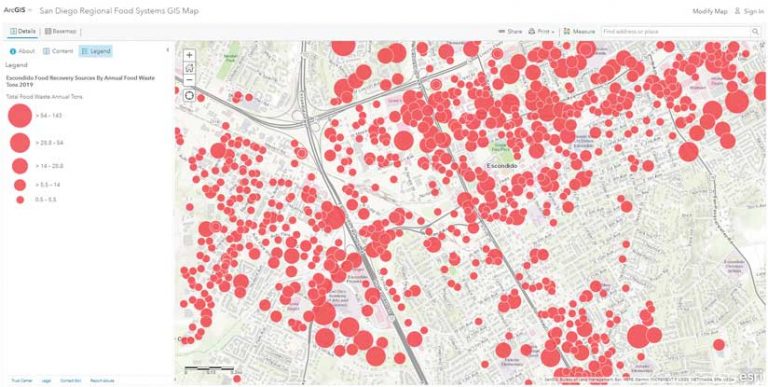
This data is then used to calculate the tons of food waste generated by local businesses on an annual basis. Ultimately, the datasets are provided to GIS students at Palomar College to geocode and analyze. This data is visualized as point data that is categorized based on state land-use codes and the quantity of wasted food generated at that location.
“Having this information in GIS helps our local cities address the state’s mandate to plan and reduce/redirect food waste. So far, approximately half of the municipalities in San Diego County have their datasets on our GIS platform and we continue to engage in discussions with other local cities on how they may take advantage of the platform themselves,” said Jones.
“The Wasted Food Prevention Program provides technical assistance, consumer education, and network development to raise awareness about the issues of food waste,” said Grootenhuis. “Our alliance between SDFSA, NCFPC, and Palomar College has opened up the powerful analytical capabilities of GIS to us. With its custom mapping tools, the technology also allows us to clearly depict the local issues that contribute to food waste, which helps prevent good food from ending up in the landfill.”
The project was fully implemented in the fall semester of 2015. Cheung’s students in his introductory GIS class began by geocoding the spreadsheets created by NCFPC that detailed its partners’ locations. Semester by semester, both beginning and advanced GIS students at Palomar added data layers and updated existing ones. For example, students mapped the participation rate in free and reduced lunch programs in San Diego County schools.
Over the years, Palomar College students have used ArcMap, ArcGIS Pro, and ArcGIS Online to process, analyze, and share the data they received from community partners. The data is provided by a variety of sources, including local government agencies, school districts, and other community agencies in the region.
Although the project started with data layers that only covered North San Diego County, over time the value of this information attracted the attention of local governments and nonprofits from all over San Diego County, so relevant data layers that include the entire county were created and added.
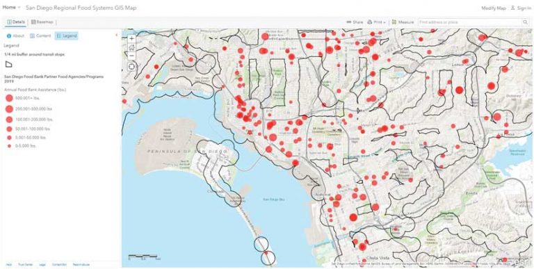
This is particularly important because the San Diego Food System Alliance has substantial regional connections and the resources to market the value and use of the map throughout the region. The web map has received thousands of views, and has nearly 50 layers, which can be turned on and off by various users. (See the San Diego Regional Food Systems GIS Map).
Since its beginning, the partnership between NCFPC, Palomar College, and SDFSA has evolved in response to the needs of communities in the region. These service-learning projects demonstrate how GIS can enable educators to build partnerships with community organizations to address many more real-world problems. It began by mapping existing food assistance programs and sociodemographic data to serve those in the region that suffer from food insecurity. Today, the program has expanded to explore opportunities to combat issues such as food waste, climate change, and transportation issues while continuing its focus on food insecurity.
“We have found that using GIS provides us with insight into social services and equity issues far beyond the issue of food insecurity,” said Jones.
The Alliance for Regional Solutions is now pursuing a grant from the State of California that will be used for planning transportation systems for disadvantaged populations living in San Diego’s North County. Palomar College students have made maps that show the location of disadvantaged communities in relation to their current public transit options. These maps will provide the justification for the grant.
To facilitate the application process, Cheung and his students provided Jones with a data layer of census tracts via ArcGIS Online, which enabled Jones to create custom maps that highlight the transportation needs specified in the grant proposal.
“Those involved in social justice issues in San Diego County are learning that GIS tools can be used to analyze and visualize pressing regional problems,” said Cheung. “The projects developed by our partnerships with local agencies require students to apply their classroom knowledge of GIS to research, analyze, and solve real-world problems related to food insecurity and food waste in San Diego County. The program also enhances the students’ communication skills, as well as their awareness of social justice and equity issues in the community.”
About the author