Despite the narrowing of the gap between GIS and building information modeling (BIM) over the last few years, architecture, engineering, and construction (AEC) firms and their clients are still battling with disparate data on multiple platforms. They struggle to provide a single authoritative view of project data to communicate project information easily and securely.
A new product, ArcGIS GeoBIM, delivers an innovative, easy-to-use web-based experience for project teams to explore and collaborate on BIM projects and issues using data from multiple systems in a geospatial context. ArcGIS GeoBIM enables the linking of projects and workflows by connecting ArcGIS with the Autodesk Construction Cloud and BIM 360. [Autodesk is an Esri partner.]
Within an ArcGIS GeoBIM project, georeferenced ArcGIS features can be linked with Autodesk records so it’s easier to access, visualize, and query project documentation from multiple sources. ArcGIS GeoBIM also makes it easier to communicate and collaborate within a secure, web-based environment, which can be tailored to the needs of multiple stakeholders.

ArcGIS GeoBIM will benefit customers in any sector in which organizations construct, manage, or renovate fixed physical assets such as road networks, rail networks, utility networks, campuses, and water facilities. However, for AEC executives and project managers, and facilities owners and managers, ArcGIS GeoBIM can deliver new benefits from connecting GIS and BIM.
AEC executives need visibility into the data and documents that their teams are managing so that they can measure progress, understand risks and costs, and communicate seamlessly with stakeholders. AEC executives also want to differentiate themselves from competitors by streamlining processes and providing better insight into projects for their clients.
ArcGIS GeoBIM provides a single common experience to access project data. By leveraging ArcGIS and the Autodesk Construction Cloud in a web-based app, digital models, GIS data, supporting documentation, and issues can be consolidated both within a single project and on a portfolio level.
In addition to viewing up-to-date BIM and GIS data, maps can be connected to dashboards and tabular data that provides insight into how a project is progressing. For example, issues can be mapped and tracked according to issue type, subtype, and status. As team members collaborate and resolve issues within the Autodesk Construction Cloud, that information is automatically visible to stakeholders within ArcGIS GeoBIM.
ArcGIS GeoBIM also enables more seamless communication of project information with stakeholders. ArcGIS GeoBIM apps provide a secure and highly configurable way for AEC executives to access views into a single project, or a portfolio of projects. As stakeholder needs change, apps can be tailored to provide different dashboards, types of information, and functionality, with the ability to securely control who can see apps and data.
Often AEC project managers find that their teams are spending time locating and re-creating project information; converting data from one format to another; and building one-off, bespoke tools to provide visibility into project locations and status. These workflows are ineffective and inefficient and eat into budgets.
Design managers, construction managers, project managers, and others want to organize projects without reorganizing data; minimize data conversion; and use out-of-the-box, enterprise-ready tools to provide tailored experiences for different team members and stakeholders.
ArcGIS GeoBIM links directly to BIM data stored in its native environment. ArcGIS features are linked to dynamic BIM datasets so that when a construction sheet is updated or a new model version is uploaded to the Autodesk Construction Cloud, that information is available at once. The need for data to be moved, duplicated, or converted is greatly reduced, saving teams time and effort.
ArcGIS GeoBIM also gives AEC project managers a highly configurable environment connected to the Autodesk Construction Cloud that can be used to meet standards such as ISO 19650. It can also provide a scalable web experience that can be reused on future projects, minimizing the risks and costs associated with one-off, in-house custom tools.
People who own and manage facilities, assets, and capital projects need an overview of all their current projects, but information on maintenance and management is often separated from design and construction documentation. They need insight into their portfolio and want asset and engineering documents at their fingertips, They also need to share project information securely and easily within their organizations’ departments.
ArcGIS GeoBIM can be configured for a single project or a portfolio of assets, and it can be easily accessed by project members and members of other departments without the need for specialized tools or training.
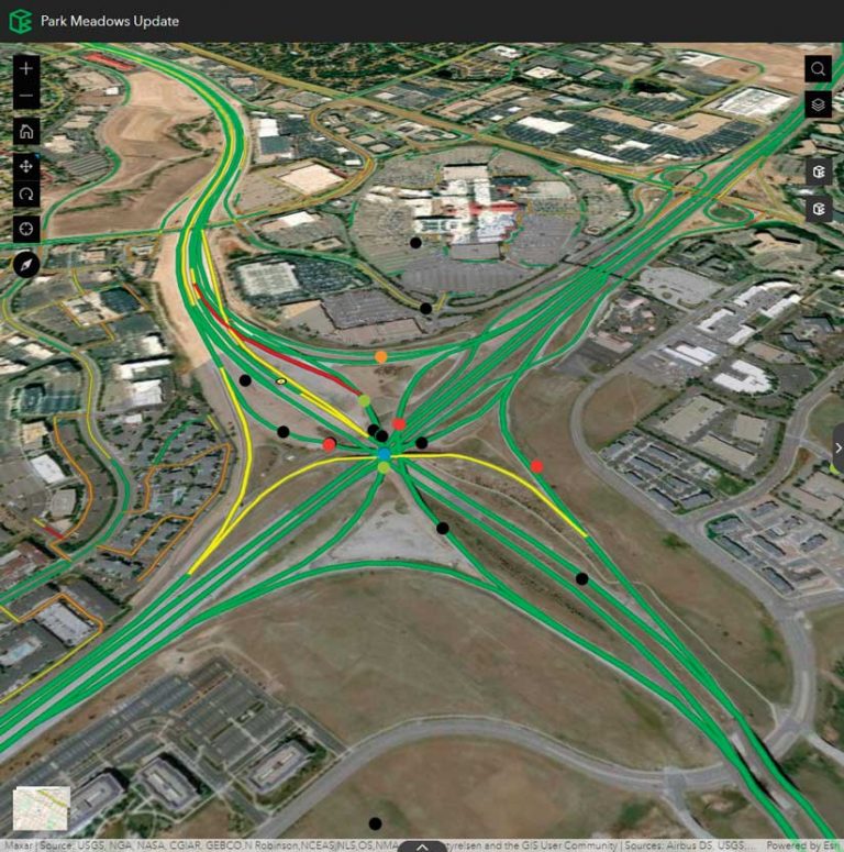
Teams can find construction documents, models, and other asset information using an ArcGIS GeoBIM app that combines a web-based map with data in multiple systems. They can search existing GIS features, find related linked datasets from the map, and view models within the Autodesk Construction Cloud, and know that they are seeing the latest versions of relevant content being served directly through ArcGIS GeoBIM, using the Autodesk Forge Viewer.
Organizations can communicate directly through the Autodesk common data environment. A geospatially enabled view creates a truly connected experience, from planning to design to construction to maintenance. Detailed digital records can be passed to the owner or operator, increasing their understanding of the built assets they own and empowering them to make better decisions.
ArcGIS GeoBIM delivers an innovative, easy-to-use web-based experience for project teams to explore and collaborate on BIM projects and issues using data from multiple systems in a geospatial context. AEC teams and owners can work with linked data from multiple systems in configurable web apps that simplify communication and collaboration with teams and stakeholders. With ArcGIS GeoBIM, teams spend less time on file conversion, thus increasing access to reliable, up-to-date data while enabling secure access to project information. Visit the ArcGIS GeoBIM page for more information.