In 2009, Ohio State University (OSU) announced the Buckeye Building Information Modeling Initiative to improve decision-making and management of the hundreds of facilities on its campuses.
OSU was originally founded in 1870 as the Ohio Agricultural and Mechanical College. The university’s name was changed eight years later when it graduated its first class of six students.
Today, OSU’s original Columbus campus enrolls nearly 60,000 students. In addition, OSU has six regional campuses throughout the state, where more than 6,000 students study. OSU’s multicampus facilities encompass 1,283 buildings that occupy about 16,000 acres (or 65 square kilometers) with infrastructure that rivals that of a small city.
OSU’s Facilities Information and Technology Services (FITS) department is a longtime user of AutoCAD and has implemented EvolveFM for space management and Revit for its building data. In 2013, the department decided to standardize on the ArcGIS platform for all its geospatial data.
“We took this step because we wanted to implement a platform that could integrate our existing systems within a geographical context,” said Larisa Kruger, OSU GIS manager. “Our AutoCAD system was primarily used for utilities, construction, and some basemapping, but it provided little data attribution and had no accessibility outside of our department.”
Campus-Wide Access to GIS
FITS originally set up a GIS advisory council to help define the university’s GIS needs and create a wish list of geospatial datasets and necessary field data collection. “We wanted to serve the entire campus and prevent isolated or redundant implementations,” said Kruger. “So it was decided to implement an ArcGIS site license to allow access to the platform throughout the entire campus network.”
The university’s software stack includes ArcGIS Enterprise, ArcGIS Pro, Esri CityEngine, ArcGIS Online, ArcGIS Hub, and ArcMap,. AutoCAD and Revit from AutoDesk are used to create 2D drawings and 3D models. FME from Safe Software is used for data conversion. EvolveFM from CAFM Resources is used to extract floor plans from the AutoCAD or Revit 2D DWF files, which are georeferenced for use in ArcGIS.
The ArcGIS platform not only provides integration and standardization of the data from FITS as well as other systems across the campus, including the Space Information Management System from EvolveFM and the facility condition index, but also allows the data to be widely distributed throughout the university for many administrative, management, and service-related functions. FITS uses the ArcGIS platform as an asset management system for data/asset collection, management, and analyses; planning; design; and construction.
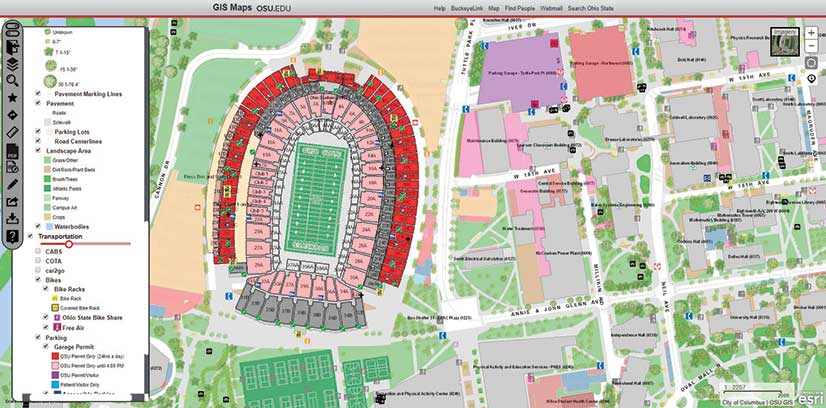
FITS has developed several GIS applications that deal with asset management and maintenance issues. The primary application is GIS Maps, which provides answers to general queries about buildings and available transportation options. Related information includes each asset’s location, condition, and general specifications, such as its square footage and the materials used in its construction. Links to leases, CAD drawings, and other documents are also available.
The application also dynamically symbolizes and filters campus buildings by various criteria including use, condition, and amenities. The app provides a choice of basemaps and shows campus roads, parking lots, and landscape information. Restricted information, such as public safety data related to blue light emergency phone locations and numbers, patrol zones, and surveillance camera locations, can be accessed with appropriate credentials. Extensive utilities data showing line, valve, and meter locations for the entire campus can also be accessed.
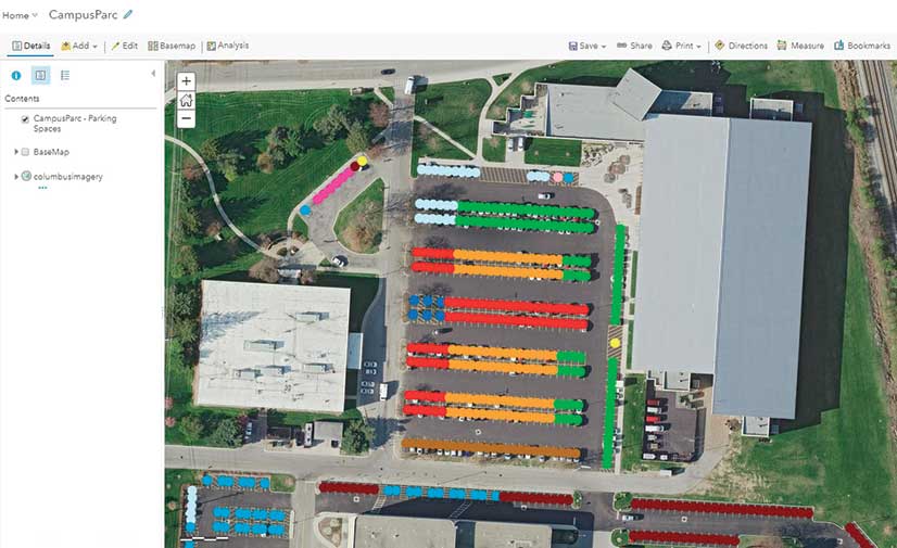
The university’s Design and Construction and real estate departments make extensive use of GIS Maps. The real estate department tracks all university parcels, easements, and leases. Non-GIS staff develop map documents for real estate transactions. To support planning efforts, the GIS analyst creates hard-copy maps for meetings of the board of trustees,
Design Review Board and Student Life
GIS Maps is interactive. Crowdsourced data can be incorporated using a redlining tool available to logged in users who can mark up the map to indicate features that are incorrect or need updating.
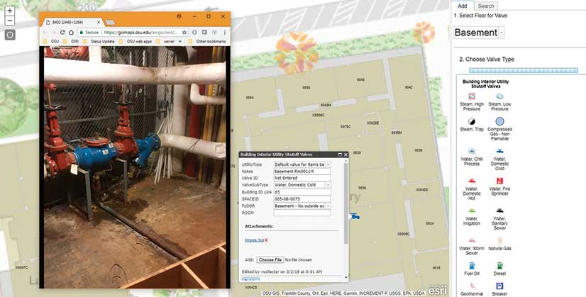
Other asset management apps include the Shut Off Valve application, which collects and updates the location of shutoff valves both inside and outside many OSU buildings. The app includes pictures of the valves to assist in locating them. Collector for Trees records and tracks tree maintenance activities such as the removal of dead trees and the planting of new ones. The Collector for Street Furniture app records updated information about the location of campus benches, tables, trash containers, and other outdoor assets. Other applications have been developed related to space planning, emergency phone locations, energy consumption monitoring, and crime mapping.
GIS is also expected to play a major role in the redevelopment master plan for the OSU Columbus campus. Work on the plan, known as Framework, began in 2010. It includes new facilities, roadway realignment, restoration of a local lake, the creation of a protective flood barrier, and other major infrastructure projects. The first phase of construction began in fall 2017 with the realignment of Cannon Drive, a major thoroughfare for OSU.
FITS also shares its data with outside agencies. The department updates address points on campus and shares the data with the Mid-Ohio Regional Planning Commission (MORPC) and the City of Columbus.
Developing OSU’s Digital Twin
OSU has used AutoCAD to record and store data about the geometry of its facilities for many years. Its extensive database of detailed AutoCAD files includes information such as floor measurements and the location and size of windows, doors, and stairwells. In a major initiative to expand the use of these 2D drawings, the university began converting the AutoCAD floor plans into 3D models using Revit, a related Autodesk software product.
Revit is software designed for building information modeling (BIM). It provides the compilation, connectivity, and digital construction for an accurate 3D model of a building by assembling the multiple 2D plan drawings used in its construction or documentation with the vertical measurements and connectivity between the floors.
Revit supports BIM workflows, and Revit files are exported to an Industry Foundation Classes (IFC) data model that can include both the geometry and nongeometric design and the construction information required by BIM. This model is then exported to FME for integration into the ArcGIS Enterprise geodatabase.
The Buckeye Building Information Modeling Initiative has two sections: one for existing buildings and one for proposed buildings. For existing buildings, FIT is converting existing 2D AutoCAD-based floor plans to 3D Revit-based building models. “There are more than 500 existing buildings that we are converting to as-built architectural models,” said Kruger.
For the second section of the BIM initiative, BIM for Design, Construction, and Operations, FIT has developed a BIM project delivery standard for all projects over $4 million that mandate the use of BIM and a Revit deliverable.
“We are currently determining how to use the data and geometry from this process in the best way for operations. The models we receive from projects that utilize the BIM project delivery standard will contain a significant amount of asset and construction data,” said Kruger. “Although we have chosen to use the architectural engineering [AE] models which do not have as much data as those needed for construction, the information in them is sufficient—for now—for operational purposes.”
This process is more about the data than the geometry, and once the data has been incorporated into the university’s operational systems, such as AssetWorks AiM facilities management software, it will be maintained in those systems rather than the AE models, although AE models will be as up-to-date as possible to ensure that they reflect each building’s current state.
Though OSU has created representational models of existing buildings in BIM that serve as architectural rather than construction models, BIM can include extensive smart facilities data. This data can be used for architectural design and engineering; mechanical, electrical, and plumbing (MEP) applications; and structural engineering and building construction. With the inclusion of sensing devices with related monitoring software, like OSU’s Shut Off Valve application, it can ultimately be used to create an intelligent 3D model or digital twin of the existing facility, which greatly enhances the support for facilities management, maintenance, and safety.
Better Infrastructure Planning and Operations
Previously, data was either uncollected or siloed away from those who need it. Using ArcGIS and other systems to collect and house data presents opportunities that will enhance the way OSU plans and operates its physical infrastructure. A system that gives operations staff members access to all the data they need from one source to do their jobs can potentially bring great efficiencies to their work.
“Our goal is to make these robust facilities data available across our entire campus through user-friendly systems,” concluded Kruger. “Our team exists to support decision-making across the life cycle of our building and infrastructure assets. We will do this by ensuring all decision-makers have access to the data they need, when they need it, and in an easy-to-use format. Having access to more data from the construction process aids in our ability to maintain our facilities long term.”
About the author