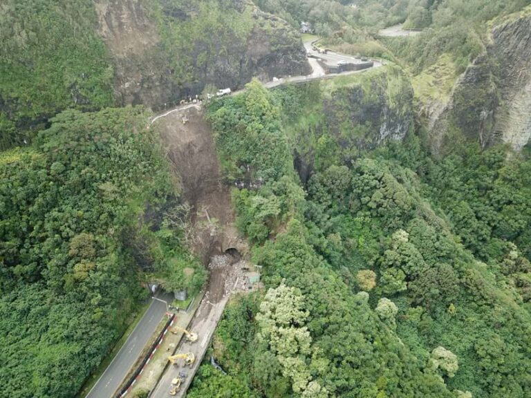
When heavy rainfall caused mud and trees to slide down the Pali Highway on Oahu in December 2023, access to roads in and out of town was blocked. A scenic 10-mile main thoroughfare also known as Hawai‘i Route 61, the Pali Highway connects downtown Honolulu to Kailua and fields thousands of drivers’ worth of traffic during the morning commute alone.
Dudek, an environmental and engineering consulting firm, was able to jump into action, using drones and GIS technology to quickly collect and share road conditions with government agencies, helping them unblock this critical route. Department of Transportation crews removed over 30 truckloads of mud and debris off the highway, careful not to destabilize the slope of the hill.
One reason Dudek was prepared to tackle this emergency was that the company had recently introduced Site Scan for ArcGIS into its land surveying workflow, modernizing the way the company collected and processed drone imagery.
In addition to emergency management operations, Dudek helps clients with scheduling, designing, and permitting for their construction projects, using GIS technology to complete projects on time and within budget. These clients work in a variety of industries throughout North America, including water utilities, energy, retail, conservation, education, and health care. Combining drones with GIS was a new approach for Dudek, and the main clients that staff initially identified as ideal for this integration were those working on renewable energy projects.
“We did site planning, engineering, and evaluations to determine if a site was viable for solar development,” said Steven Hochart, practice director at Dudek. “The faster those clients could get data, the faster they could submit their application to the local utilities to get their project in the queue. For them, it was all about speed. If we collected drone data for a small site in the morning, the client could see the data by the afternoon.”
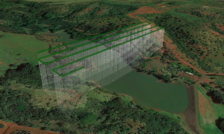
Dudek collected aerial imagery data with drones and analyzed it using GIS, then presented the results to clients as a dynamic visualization. From easements being plotted to topographic data, everything is accessible on a near real-time map of the project schedule.
From Disconnected Systems to a Centralized Database
In the past, Dudek had used multiple systems to plan drone flights and collect imagery data in the field. Initially, they used UgCS, unpiloted aerial vehicle (UAV) software for geophysical surveys. Data from UAVs was stored on laptops and transferred to Dropbox, a file storage software with cloud storage. Eventually, the data was moved onto servers. Imagery processing was handled by Agisoft Metashape, a tool for photogrammetry, adding more complexities to Dudek’s workflow. This disjointed process was inefficient due to the lack of integration, and expensive because each system had its own costs associated with it. Additionally, traditional methods like helicopters and airplanes used to survey land and collect imagery data were slow and costly.
“We had to mobilize a plane if there weren’t any in the area,” said Hochart. “We had projects all over the country, so drone technology was critical to our business.”
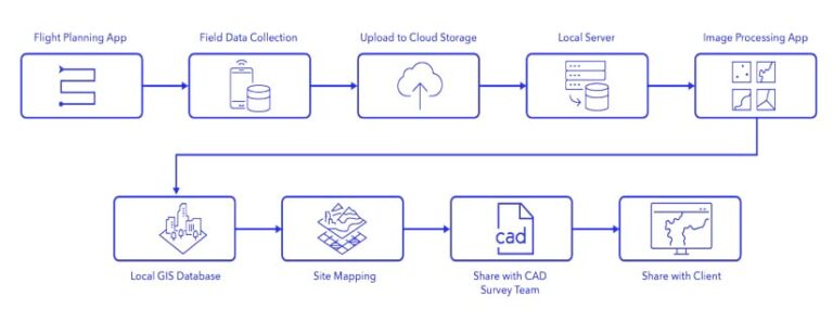
Staff at Dudek recognized the need to streamline their operations to eliminate unnecessary steps and costs to get data to their customers faster. Dudek saw Site Scan for ArcGIS as an opportunity to fix the company’s fragmented workflow and modernize its drone imagery collection, processing, and analysis with end-to-end, cloud-based drone mapping software. Staff at Dudek were already well acquainted with ArcGIS software, so incorporating the tool into their existing GIS infrastructure was easy.
“For us, Site Scan is a very simple solution,” continued Hochart. “We have mobile teams using ArcGIS Field Maps, mappers using ArcGIS Pro, and our surveyors are using [ArcGIS for AutoCAD] to create a database for us.”
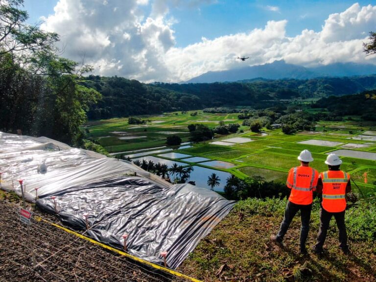
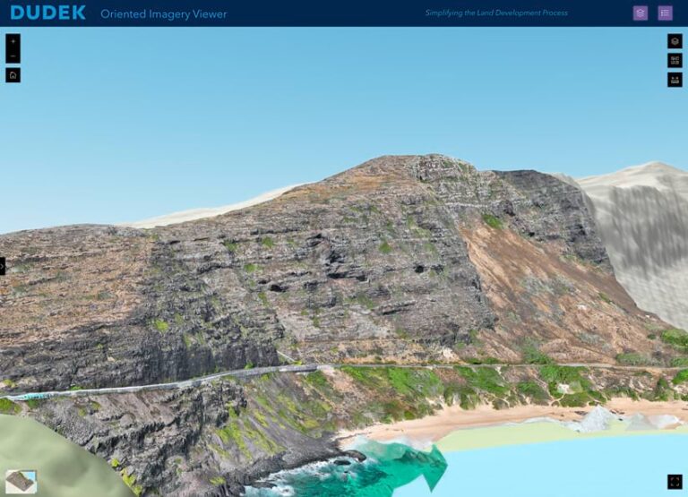
With Site Scan fully integrated into their workflow, the staff uses it for flight planning, data collection, and processing. The GIS team also uses Site Scan for mapping and integrating GIS and computer-aided design (CAD) data to share in real time with other staff and customers into a custom-built site called the Dudek Land Development Portal. The portal combines GIS and CAD data for faster, more informed decision-making.
By transitioning from previously outdated, disconnected systems to Site Scan to gather, organize, and analyze drone data, Dudek saved over $80,000 in one year. The new portal was what provided staff with the opportunity to put this innovation to work right away on landslide mitigation and emergency response in Hawai‘i.
This newfound efficiency was particularly evident on smaller projects. Personnel could capture, process, and share imagery in a single day, impressing clients with quick turnaround times.
“We do a lot of work with rockfall hazards,” said Hochart. “Captured with Site Scan, the clients love it because they get a dynamic 3D view where they can pan around, zoom in, and get an understanding of [the site].”

Advancing the Industry
Now that staff at Dudek are comfortable integrating GIS software and drones, leadership is looking to explore more ways to serve clients and transform the land surveying industry. Dudek is actively reaching out to similar firms in sectors like the civil engineering field to demonstrate how they implement GIS and drone technology in a cloud-based system.
“We weren’t shipping hard drives around [the US], waiting for things to upload or sitting in a hotel dealing with VPN issues,” continued Hochart. “For the land surveying industry, this is a big deal.”
Additionally, Dudek hopes to advance the land surveying industry by including more geospatial artificial intelligence (GeoAI) into their workflows. GeoAI combines AI with GIS, giving maps and other spatial tools capabilities like automated data processing and even predictive analysis. For land surveyors, GeoAI can be leveraged to extract key information from documents and drone imagery, supporting the land surveying process.
“We fly a site anywhere from five to 2,000 acres, creating planimetric data for those sites,” said Hochart. Planimetric data provides crucial information about the measurement and mapping of the locations and shapes of roads, buildings, rivers, and other landmarks as they appear from an aerial view. “Having the ability to use GeoAI within the GIS system helps us streamline the creation of our planimetric and basic image segmentation to integrate with CAD and BIM systems later on.”
Once Dudek’s surveyors gather all the data needed with Site Scan, they can create and share a digital twin in a single view with ArcGIS GeoBIM. Combining the spatial analysis capabilities of GIS with detailed 3D design and construction data, these digital twins are dynamic virtual representations of reality that provide contextual understanding of built environments.
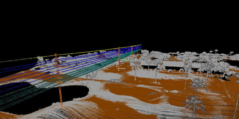
For instance, Dudek collected imagery data for wastewater utilities by using a UAV to fly street corridors. In the past, the company would send mobile surveyors to collect GPS data from sewer lines and water meters. This approach was inherently risky because staff had to walk along roadsides to access the water system. Now, with GeoAI and digital twins, drone data and GIS workflows are easily integrated within the utility network schema.
Hochart noted that this approach streamlines operations for civil engineers, GIS users, and site designers from the very beginning by prioritizing the collection and processing of data-rich imagery with drones using GIS technology throughout the life cycle of a project. “That first aerial image of a site sets the foundation for any future planning,” he said.

