Every university graduate wants to know that their future work will be valued and valuable, so preparing for the careers that will be highly sought after is crucial. Data and business analysts will be in increasingly high demand soon, according to the US Bureau of Labor Statistics. By 2029, these fields are expected to grow by 26 and 11 percent, respectively, higher than average growth rates.
The College of Business and Public Management at West Chester University (WCU) in West Chester, Pennsylvania, is helping students get ahead and meet workforce needs by using locational analytics in undergraduate and graduate programs. The school’s Department of Geography and Planning has taught GIS for more than 20 years.
“WCU takes an interdisciplinary approach to our programs and colleges. We consider GIS to be another form of analytics that just uses location as the focus,” said Evan Leach, PhD, dean and professor of management at WCU. “GIS is a really important tool to answer strategic business questions and address business challenges.”
“Our hope is that students don’t approach today’s problems with the mindset of siloed majors like business and geography, but rather approach problems holistically and through an interdisciplinary lens,” said Leach. “Achieving that comes from not thinking in a traditional sense. Just because a business program hasn’t had a prominent GIS program in the past, doesn’t mean it shouldn’t be open to developing one in the future.”
And developing a business-centered GIS program is what WCU faculty have set out to do.
Introducing a Location Perspective
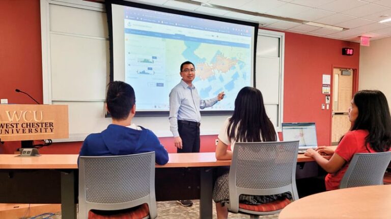
A major contributor to WCU’s status as a leader in location-informed business education is Phuoc Pham, PhD, assistant professor of management at the College of Business and Public Management. Pham teaches a supply chain course required for both business majors and minors that is typically offered year-round. Pham’s course explores the fundamentals of supply chain management, including how to leverage big data and other technologies to solve supply chain issues. Course topics include cloud computing, machine learning, the Internet of Things (IoT), and—most recently—GIS and location analytics.
“We don’t want to throw a bunch of theory and textbook materials at students to solve a supply chain problem. We wanted them to be able to analyze them and know how to use a specific tool to do so,” said Pham.
Pham was looking for a way to add a stronger analysis component to the course when he attended a GIS presentation in the fall of 2019 that was hosted by WCU’s geography department. The department had invited an Esri representative to present on the technology. “It was a eureka moment,” said Pham. “This was the technology I was looking for, and I began learning how to integrate the tool into my course to make it more relevant to solving the problem.”
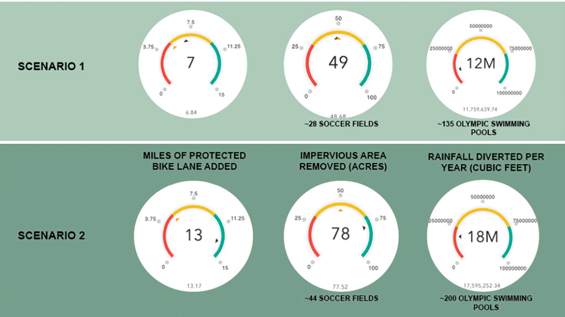
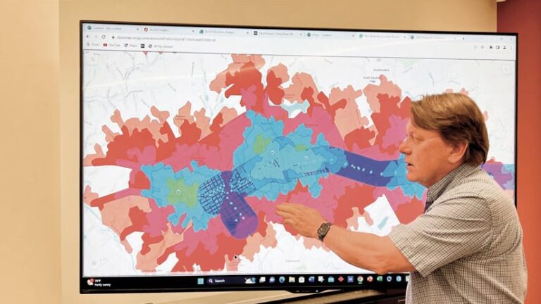
Pham collaborated with fellow WCU staff members to learn how to use ArcGIS technologies. In the winter of 2020, he began testing core concepts in his class using Learn ArcGIS, a collection of online tutorials that contain ready-to-use lessons based on real-world problems. By spring 2020, Pham had fully integrated ArcGIS Business Analyst, ArcGIS Pro, and ArcGIS Online into his course so that students could analyze and map supply chain challenges. Students also used ArcGIS StoryMaps to present and publish their assignments on the web.
To help students adapt and become comfortable with the software, he created guidelines on how to use the technology in a supply chain context. He paired these resources with sample business problems he had created and supplied data for the students to analyze.
“It really was the right time to integrate these technologies and prove how important location was to these business problems,” said Pham. “The pandemic was happening, and supply chain challenges were a hot topic to discuss.”
Pham shared with his students some examples of supply chain problems that were happening due to the pandemic and thought leadership pieces about solving them with maps. “Students really enjoyed the course because they could clearly see the application of these tools,” said Pham.
Applying GIS Knowledge to Real-Life Problems
While Pham worked with organizations to get case studies for his course, the business school eventually developed a case competition in spring 2022. The competition exposed students to a real-world business challenge to build their résumés, provided an opportunity to network with executives, and revealed job opportunities. The success of the first case competition has led to new sponsorships with other businesses and provided students with internship, job, and experiential learning opportunities.
“It’s clear that these skills are highly desired in the market. Students need to know how to use data to solve problems and make decisions,” said Pham. “I am lucky to work on a team that has the same mindset and strategy that we are doing the right things for students.”
From the success of integrating location analytics in his supply chain courses, Pham hopes to expand the use of this technology in his logistic courses. He encourages other university professors to bring tools or skills they find valuable into the classroom.
“I saw this was a great tool, and that I just needed to do it, so I learned by doing as I went, “ said Pham. “I want to see other business schools do this too; you can do it, and your students can too.”
A Foundation of Essential Workplace Skills
Undergraduates at WCU can pursue a bachelor of science degree in geography with a location analytics track, as well as minor in GIS, business analytics, or business GIS. The college also boasts accelerated master’s degree programs in geography from business management, international business, marketing, and supply chain management perspectives.
Leach observes that as organizations and businesses leverage the benefits of big data, business schools will need to adapt curricula to marketplace expectations and student preferences. “Universities need to have a lifelong learner mindset and develop a model that supports students long after they graduated with their bachelor’s [degree] and throughout their careers,” said Leach. He noted that it will be crucial for universities to consider developing certification programs that meet business needs for workforce technology training.
WCU has already begun this process by developing a new major in business analytics with a GIS-focused track and requiring students in the major who are on other tracks to take one dedicated GIS course. The college is also developing a GIS certificate for undergraduate students who want to supplement or specialize their skill sets, regardless of their major.
“Our hope is that GIS becomes a tool that is widely used by people strategizing and making business decisions,” said Leach. “We are proud of what we have been able to accomplish at WCU and remain in constant conversation to move forward.”