Within minutes GIS analysts can create lightweight, interactive web apps that enable stakeholders to explore collections of carefully curated geospatial content using a new app template in ArcGIS Instant Apps. Atlas allows GIS analysts to create a digital atlas that is easy to explore and presents layers of context that enable users to conduct simple analyses and allows for easy sharing.
Organizations of all types need to leverage geospatial data in ways that improve operations, support collaboration, and boost business outcomes. Being able to quickly implement solutions that make data more accessible to stakeholders across an organization is key to making this happen. There are several advantages to using Atlas to build simple apps of curated content to leverage organizational geospatial data.
It’s Easy to Assemble a Relevant Data Collection
When GIS analysts first receive a request, they need to identify the relevant data and where it is located. Often, relevant data is stored privately on someone’s computer, shared with a specific group in an organization, or saved within another organization’s system.
After the required data is located, GIS analysts must load that data into ArcGIS Online and organize it so that end users can access it. Commonly, this is done by creating a group in ArcGIS Online for gathering curated content and granting access to stakeholders—both inside and outside the organization—by making them members of the group. Another strategy used by GIS analysts is establishing a partnered collaboration between ArcGIS Online organization group members to view or retrieve content from other organizations. Implementing distributed collaboration between ArcGIS Online and ArcGIS Enterprise organizations is another way to make content accessible.
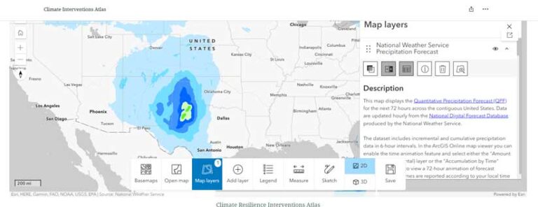
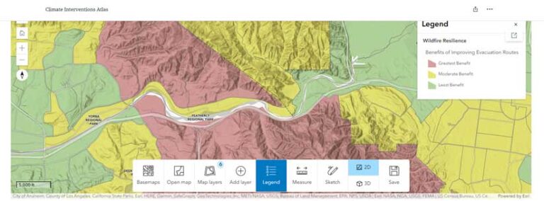
GIS analysts can use the Atlas template in ArcGIS Instant Apps to create an inter-active app that allows users in a group to explore atlas content. All the maps and layers added by the group automatically populate the Atlas app, which puts them in one place where group members can access them. (Alternatively, GIS analysts who don’t create a group in ArcGIS Online can manually pick and choose content to add to the app as they’re configuring it.)
Atlas automatically pulls in each item’s title, thumbnail image, and description and organizes the content into predefined categories that are relevant to the group. This lets users of apps built with the Atlas template easily browse the maps and layers or search for specific content using keywords.
To create a good user experience, GIS analysts should determine the content that is most relevant to the app’s audience and double-check that those maps and layers have easy-to-read pop-ups and sufficient metadata. They should also organize the content into categories that are pertinent to group members and create bookmarks that users can employ to focus the map on certain areas of interest.
An Intuitive Map Exploration Experience
Since the users of an app may have limited or no experience with GIS, GIS analysts need to ensure that all members can effectively explore and interact with the data and discover the information they need without guidance.
Atlas enables GIS analysts to efficiently create a simple app that allows users to open various maps from a gallery and interact with different areas on a map by searching for a location, zooming to a spatial bookmark, opening the legend and pop-ups, using a swipe tool, and measuring distance and area. Users can also choose other basemaps and add or remove map layers to gain additional insight. The Atlas app-building template includes a large toolbar menu on the bottom that allows GIS analysts to add or remove tools to best suit the group for which they’re building the app.
Stakeholders Can Save and Share Their Work
In many instances, stakeholders need an easy way to share the geospatial work they’ve done so that they can effectively collaborate with others. For example, after a hurricane, a city government GIS department might be asked to coordinate with numerous outside organizations: emergency medical teams to coordinate rescues; the media to keep members of the public updated; federal agencies to get aid; and insurance companies to report damaged areas.
Apps made using the Atlas template allow users to employ sketch tools to make notes and mark locations on a map. Users can explore a map, add notes and markups, and save this work as a new map in ArcGIS Online. They can also create an entirely new app with it, such as an ArcGIS StoryMaps story. Their work can be shared with other stakeholders by taking a screenshot of the map or exporting the map as a PDF.
Quickly Meet Deadlines and Organizational Requirements
Even when GIS analysts need to create solutions on a short timeline, those solutions often must meet their organizations’ requirements for accessibility, mobile responsiveness, and even branding. GIS analysts and other app creators can build focused, interactive web apps from their maps in minutes using Instant Apps templates—including Atlas. All the theming tools in other Instant Apps templates are available in Atlas.
Default express setup options, such a preset theme and simple map tools like search and zoom control, let GIS analysts publish apps quickly by only including the essential settings in Atlas. For apps that require additional customization, they can use the full configuration options of Atlas to explore and add more map tools and change the app’s appearance by including items such as adding a cover page, inserting a customized app title, or incorporating a logo.
Purpose-Driven App Templates
With 18 purpose-driven app templates—plus two in beta—Instant Apps enables GIS analysts to quickly build apps that can display an organization’s collection of content (using Atlas, Portfolio, and Category Gallery); showcase 2D, 3D, and temporal data in a map (using Sidebar, Insets, Exhibit, 3D Viewer, Slider, and others); and deliver local information based on proximity to a certain location (using Nearby, Zone Lookup, and Public Notification). The resultant apps let users interact with different capabilities and features in a map, including attachments, charts, and bookmarks.
The apps perform well on both desktop computers and mobile devices, support accessibility, and include theming tools that help GIS analysts customize the look and style of their apps to conform to their organizations’ branding requirements. Instant Apps is part of the essential apps bundle in both ArcGIS Online and ArcGIS Enterprise, and using these apps requires no additional licensing.