Mapping your field data has never been easier—or more powerful. Mapping field data has been a major activity for research and exploration for centuries. More recently, it has been viewed as a valuable activity in education.
Why should you collect and analyze field data? Why should you use ArcGIS for these tasks? How can you collect and analyze field data in ArcGIS Online? What are some resources that you can use to continue to learn more about fieldwork? This article covers these topics in a way that is accessible even if you are new to fieldwork and mapping. Resources provided at the end of the document will help you dig deeper into these topics.
Why Do Field Mapping?
Why should you map field data in the first place? According to the National Research Council Learning to Think Spatially report (2006), spatial thinking and uncovering spatial patterns are fundamental to understanding. GIS provides the technology to map and visualize information. Indeed, ArcGIS provides a complete platform for mapping via a wide variety of file formats and data gathering devices. In addition, every issue critical to the 21st century has a spatial component—energy, water quality and availability, biodiversity loss, climate, sustainable agriculture, human health, ocean acidification, population change, natural hazards, just to name a few. It is vital that we understand each of these complex issues. They are global concerns, but they also affect our everyday lives. Each of these issues requires field investigation.
Analytical mapping also has value in and of itself. It is a fundamental part of the scientific and geographic inquiry process. This process includes asking geographic questions, acquiring geographic data, exploring geographic data, analyzing geographic information, and acting on geographic knowledge. Despite the geographic words used to describe this inquiry process, it is important to note that the process can and should occur in any discipline asking the wherequestion—not only in geography, but in epidemiology, planning, business, and many other fields.
Fieldwork empowers people to get involved in community issues. It builds essential critical thinking and work force skills, such as understanding spatial and tabular data types, assessing data quality, how to collect data, how to construct databases, how to bring data from the field into a GIS environment, classifying and symbolizing data, and analyzing data. In fact, David Orr’s words from Earth In Mind—On Education, Environment, and the Human Prospect (1994) are particularly relevant here: “Now more than ever, we need people who think broadly and who understand systems, connections, patterns, and root causes…how to think in whole systems, how to find connections, how to ask big questions, and how to separate the trivial from the important.”
I believe that effective spatial thinkers need to be conversant in three main areas—content knowledge, the geographic perspective, and skills. These skills include technical, communications, and other skills that are identified in the Geospatial Technology Competency Model published by the US Department of Labor, Employment and Training Administration. Planning and conducting fieldwork and analyzing the results of that fieldwork depend on all three of these areas, whether that field data comes from biology, epidemiology, transportation, law enforcement, defense, history, archaeology, energy, natural resources, administration, geography, business, or another field.
Why Use ArcGIS?
ArcGIS isn’t just a set of web maps and some desktop tools. It is an integrated system—a platform—for making wise decisions. ArcGIS makes it easy to map many types of field data. A variety of georeferenced basemaps is available from ArcGIS Online as well as thousands of thematic layers, with more continually being added. ArcGIS makes it easy to analyze field data, both on the desktop and in the cloud. You can symbolize and classify your data, perform spatial analysis, present your results online as live web maps, embed your maps in web pages, and use them to create story maps.
Requisite Skills
Some core skills are required when considering fieldwork: creating databases; capturing the location; collecting attribute data; creating maps; and classifying, analyzing, and symbolizing data. One must evaluate the project goals, the time and equipment available, terrain, and other factors when preparing to go into the field. Planning is essential for efficient field collection that contributes to meeting project goals.
Many Ways to Add Field Data
Adding field data to your GIS environment can be accomplished from databases, social media feeds, sensor networks, imagery, services, spreadsheets, probes, smartphones, GPS receivers, and many more means. Let’s consider just five of the many ways you can add field data.
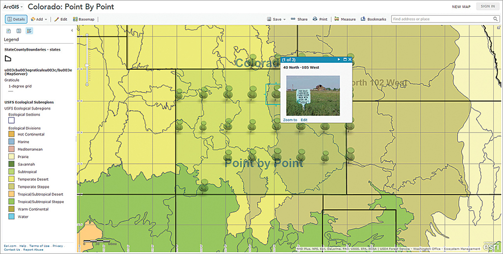
Add Map Notes
Probably the simplest way to add field data to a web map on ArcGIS Online is to create map notes. You can add map notes to indicate where you collected field data by clicking on the map at that location on the map. To find a specific location, you can input coordinates in the geographic search box at the upper right of the map. Coordinates have to be entered as x,y (in other words, longitude, latitude) and entered in decimal degrees. Don’t forget that negative numbers are needed for locations in the western and southern hemispheres. The Location tool, under the Measure menu, will allow you to check the location of your cursor’s latitude-lo
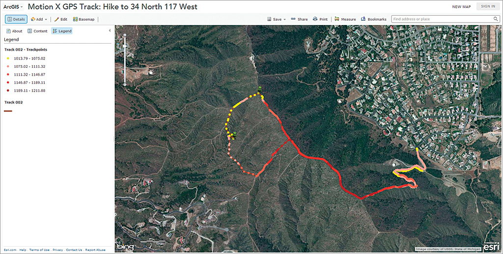
Import GPX Files
You can import a GPX file from a GPS receiver, from a device such as a scientific probe (those from Vernier or PASCO, for example), or from a smartphone. GPX is an open file format in XML used to describe waypoints, tracks, or routes. You can easily collect location data in GPX using one of the many apps available for smartphones (My Tracks or Motion X GPS). The GPX file can be added directly into ArcGIS Online; symbolized by elevation, time, or another attribute; and the resultant map saved and shared.
Create Table and Import It
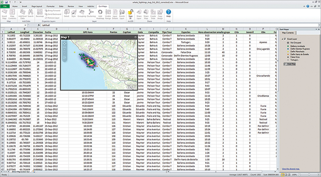
You can create a table of data and import that table into ArcGIS Online. Tables can be created in Microsoft Excel or a text editor and saved as a CSV file. You can also use Esri Maps for Office and create ArcGIS Online maps directly inside Excel, generate heat maps and enriched data products, and share those maps.
Add an Online Table
You can add a table that is already online, such as the tables of recent earthquakes from the US Geological Survey. This is helpful when mapping data that has already been formatted for use in a GIS.
Share as a Feature Service
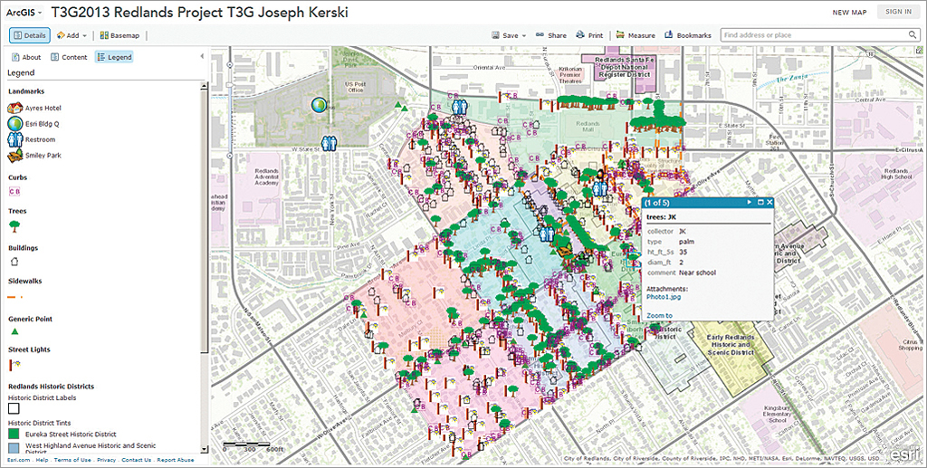
You can create a geodatabase in ArcGIS for Desktop or add content directly to My Content on your ArcGIS Online site and share it as a feature service. A feature service is more powerful than map layers generated using the previous strategies because you can perform richer analysis on feature services, add them to any ArcGIS Online map as a stand-alone layer, and make them editable.
An editable feature service can be used for citizen science projects. With an editable feature service, all the participants in your project (students in your class or members of your organization) can add data to a single common web map. Editing is controlled by the owner of the service. One characteristic of an editable feature service is that it can have domains that specify what data types are allowed and the value range for each field. When editing the data on mobile devices, domain values appear as items in pull-down menus. This minimizes manual keying of data in the field, speeding up the field collection process and minimizing data input error.
With these five techniques for easily using ArcGIS Online for field mapping, how might you use them in your own work?
Additional Field Collection Resources
For more information about collecting and mapping your field data, search for these topics on the video collection. In addition, over 1,500 videos exist on GIS in education, including several playlists on fieldwork on www.youtube.com/geographyuberalles. Several relevant courses exist on the Esri Training site. The Esri education team also frequently writes about this topic on edcommunity.esri.com/blog.