At first glance, the Grand Mosque in Porto-Novo, Benin, might seem like little more than a ruin. Built sometime between 1906 and 1912, the mosque has fallen out of use and into disrepair: discolored minarets, busted windows, splotches of flaking paint. Vegetation sprouts from its upper stories. Still, it’s hard to deny the underlying beauty of the structure, with its ornate pillars and elaborately carved facade. As a once-grand building that lacks the dedicated resources for it to be maintained beyond minimal upkeep, it’s tempting to see the mosque as a monument to urban decay.
But the Grand Mosque also tells another story. In the late 19th and early 20th centuries, many West Africans and their descendants who had previously been enslaved in Brazil came to the region, some returning home, some arriving for the first time. Some settled in Porto-Novo. These were the Aguda people, who brought with them a different set of cultural practices, faiths, and ideas. Many had converted to Islam, sometimes as an act of protest. They’d spent decades building Christian churches and cathedrals all across Brazil, particularly in Bahia.
All of this is what led the Aguda to construct the Grand Mosque with its unique architectural identity—a West African mosque that looks like a Brazilian church. And is what makes it such a striking, significant part of Porto-Novo’s history and identity.

But its future—like that of so many culturally or historically significant buildings across Porto-Novo, Benin, and West Africa as a whole—is uncertain. One local organization has begun the process of trying to rehabilitate the Grand Mosque and turn it into a museum. Other, similar sites are not so lucky.
“A lot of these buildings . . . both colonial and traditional buildings, are fast disappearing into the African landscape,” said H. Killion Mokwete, assistant professor of architecture at Northeastern University. “They’re being replaced.”
In some ways, this is understandable. Older buildings are more expensive to maintain and modernize; often, it’s more efficient and cost-effective to make way for new structures. At the same time, something is lost when these buildings disappear. A city’s buildings comprise its history, its identity, and its memory. Although it’s not always reasonable to try to preserve them forever, Mokwete and a team of researchers at Northeastern University are trying to do the next best thing—map these buildings, give them context, construct geospatial ghosts that can inform residents’ sense of where they live, and help others learn about the area’s rich and complex history.

“The idea is to create a space where we can partner with local groups in the African context—primarily the francophone countries of West Africa—in order to document and digitize architectural built heritage,” said Mokwete.
The result of this effort is the African Built Heritage Hub. Northeastern researchers are partnering with local organizations and using GIS tools such as ArcGIS Online, ArcGIS Survey123, ArcGIS Field Maps, and ArcGIS Hub—in conjunction with lidar scanning for the development of 3D digital models—to create a dynamic repository of imagery and knowledge about culturally and historically significant sites across Africa.
An Urban Context
Porto-Novo wasn’t the first location the team had in mind. While traveling through Togo, Mokwete became fascinated by takienta—mud tower-houses scattered across the Koutammakou region, which stretches across northeastern Togo and western Benin. He was struck by the fact that the takienta appear to be part of the landscape, rather than imposed on top of it. It turned out, however, that many of the buildings in this area were being replaced by new brick structures.
“I was worried that over time we won’t know we actually had these buildings,” said Mokwete.

When he approached Northeastern University with the idea to digitally preserve structures like takienta, Mokwete was encouraged to think bigger. Where else could this idea be applicable—and where were historically significant sites disappearing at ever-faster rates?
“The idea was that if we started with an urban context, there’s much more depth,” said Mokwete. “Buildings in an urban context have to deal with more demand for space and rapid urbanization.”
Other factors influenced the decision as well. Bahare Sanaie-Movahed, GIS specialist at the Northeastern University Library, noted that considerations such as changing climate conditions, infrastructure limitations, economic pressures, and conflicts across the continent meant that West Africa was the most viable region to pilot the project, with the intent to operate farther afield in the future.
Mokwete scouted a few different locations and ultimately settled on Porto-Novo. If the team members were able to test their idea in an urban area to determine if it was applicable in multiple contexts, the project could expand to more rural landscapes across Africa like the Koutammakou region and beyond.
GIS Is the Backbone
Once the team settled on Porto-Novo, it was time to collect the project data. This process required two crucial components: buy-in from local stakeholders and geospatial technology.
Since the hub’s primary purpose is to accurately document and preserve the heritage of the sites surveyed, local stakeholders were fundamental in ensuring the success of this mission, and often provided personal interviews that the team recorded and ultimately integrated into the hub. The team worked with organizations such as École du Patrimoine Africain and staff from the Royal Palace Musée Honmé, among many others.
The main data collection tools were ArcGIS Field Maps and ArcGIS Survey123, which the team used to survey and record data about individual sites, including details about the architectural features, historical or religious significance, and condition of each structure. These tools were also used to gather information from social participants—residents of the area who had expertise or knowledge about each site.
“GIS is the backbone of the work,” said Sanaie-Movahed. “We also brought in photos through [ArcGIS] StoryMaps, [ArcGIS] Dashboards; and then we started putting all this together in one ecosystem, which is ArcGIS Hub.”
In addition to the Grand Mosque, the team surveyed Zangbeto Temple—a major site in the West African Vodun religion—as well as the Musée Honmé and other significant examples of traditional Beninese, Aguda, and colonial architecture.

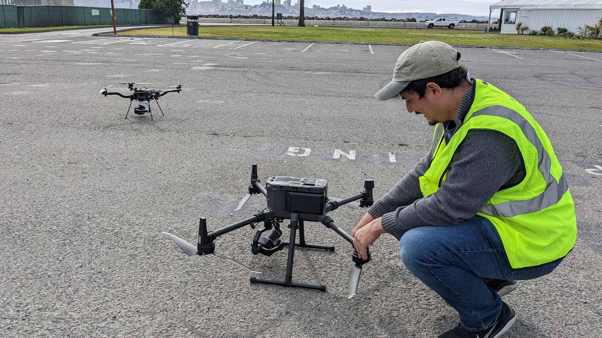
Some sites, such as the Grand Mosque, Zangbeto Temple, and Places Vodùn Rénovées d’Adjina—a compound containing multiple Vodun shrines—were good candidates for 3D modeling. The team used drones and lidar scanners to collect visual data on these sites that could then be used to construct digital models, allowing people to explore each site remotely.
This wasn’t always a smooth process—drones rely on satellite imagery to design a flight path, and the team was frequently working in areas where this imagery was slow to load.
“Imagine that you are looking on a blank page and then trying to design the flight,” said Sanaie-Movahed. “It was really challenging.”
“It’s like the [lidar] scanner,” added Mokwete. “At one point it just overheats because it’s so hot out here, and humid. These things are designed in cooler climates. When you bring it here, you have to cool it, otherwise it just breaks down on you.”
One of the central technological challenges was processing and hosting the massive files produced by lidar scans in a form that could be easily interacted with, especially in areas with limited internet access or slower internet speeds.

“I think if there’s any technological development in the way we process data, that is probably the frontier of making it easier to work with lidar,” said Mokwete.
The Past and the Future
“Once we were back in the United States, we started not only creating the hub and then bringing all those stories together, but also digitizing maps that we brought back from Africa,” said Sanaie-Movahed. “We brought back images of maps from books, from walls. And then we started digitizing the maps and creating interactive dashboards.”
This process of digitization and data aggregation was often done in ArcGIS Pro, and culminated in the Porto-Novo Building Explorer, a dashboard created with ArcGIS Dashboards that allows visitors to the African Built Heritage Hub to explore information about Porto-Novo’s historical buildings in context. This dashboard is where much of the survey data the team collected in Benin now lives, composing a vital living geospatial database of the city’s architecture.

“Some of the buildings we saw don’t exist anymore,” said Mokwete. “We were here a year, maybe two years ago, and the buildings have been demolished to make way for new developments. So if we hadn’t georeferenced it, you could have a picture, but no idea of where that picture was taken.”
The hub also includes multiple stories created with ArcGIS StoryMaps, as well as the 3D models created from lidar scans. Many of the current models are of highly visible buildings that are likely to be preserved in some physical form, but future scans may help digitally preserve buildings that could soon be erased from the landscape. Being able to explore them in a virtual reality context provides an extra layer of enrichment.
“Interactive engagement means that it’s not just an archive,” said Mokwete. “It’s also live information that people can engage with.”
But one of the benefits of an archive, interactive or not, is that it allows residents and nonresidents alike to view the city with a full breadth of context. It can help change how these sites are treated, even within a local framework.
“We are confident that the approaches we tried and piloted in Benin work,” said Mokwete. “We’re working with students, working with local organizations and partners. After the scanning and the data we’ve got now, we’re in the process of getting grants to rehabilitate one of the buildings based on the work we’ve done.”
This success is especially important as the team looks to expand the scope of the project beyond what has been accomplished in Porto-Novo and Benin.
“These Afro-Brazilian buildings are not only in Benin, they’re actually in Togo, Benin, Nigeria, and Ghana,” said Mokwete. “So for us, the idea is of continuing that as a thread, almost like a network where we can map, digitize, and geolocate these buildings across the corridor from Togo to Ghana.”
For both Mokwete and Sanaie-Movahed, a significant aspect of the project has been the relationships their team has built in the local community, and seeing the impact the project has already had on the ground. When they went to survey Porto-Novo, they found a serious appetite for geospatial memory building.

“There’s just so much potential for impact in the African context,” said Mokwete. “There’s just so much that has not been done and has not been digitized and mapped. There’s such a need and there are partners that are willing.”
“[Residents] use the tool to see what is happening around them,” added Sanaie-Movahed. “How can you create a map that is not necessarily data heavy, but truly engaging for them? They can select something on a dashboard and then look through exactly the building that they are looking for. Select the schools or the universities, whatever we mapped. See the way the city urbanized. The colonial parts, the different architectural areas on the map. What is unique about this project is this transformation of the heritage of Benin from a static archival map to a living dynamic resource.”