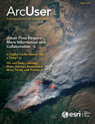
The increase in the intensity, frequency, and extent of fire events has become one of the most serious of the many adverse weather effects brought on by climate change. The United Nations reported in 2023, ”As the increasing effects of climate change and land-use change make wildfires more frequent and intense, it is estimated that we could witness a global increase in the occurrence of extreme fires of up to 14 percent by 2030, 30 percent by 2050 and 50 percent by the end of this century.”
The zone of transition between areas of wilderness and human settlement, known as the wildland-urban interface (WUI), is the fastest growing land-use type in the conterminous United States. This expansion means the millions who live in these areas are increasingly threatened by the economic, social, and environmental impacts of fire events that have been exacerbated by climate change.
This issue highlights the many ways that GIS is being used to address these challenges more comprehensively by identifying who will be affected; where they are located; and what can be done to mitigate, respond, and recover from fires. New GIS visualization and analysis capabilities that have been enhanced by the further incorporation of artificial intelligence (AI); additional data now captured by GIS on mobile devices; and the collaboration fostered by tools such as ArcGIS Dashboards, have been adopted by agencies around the world.
An article in this issue describes how deep learning models developed by Esri greatly decreased the time required to assess the damage caused by the 2023 wildfires in Lahaina, Hawaii, while increasing the accuracy of the assessment to 95 percent.
Another article highlights how GIS helps preserve and disseminate ancient knowledge. More than 700 Indigenous firefighters who work for a wildfire prevention agency in Brazil use smart maps and apps to record their traditional ecological knowledge and make it more widely available.
These examples illustrate the effectiveness of GIS in determining where impacts caused by climate change will be the greatest and identifying opportunities for adaptation, mitigation, and response.
About the author