During spring break in 2020, Gregory Brunner, an adjunct professor at Saint Louis University (SLU), quickly transformed a course he was teaching from a traditional classroom format into a remotely taught interactive experience with the help of ArcGIS Notebooks.
The sudden escalation of the COVID-19 pandemic led to the abrupt suspension of classes on campus, giving Brunner just a week to convert the course from an in-person lab to a remote course that could be effectively taught via Zoom.
Brunner, who is also a data science team lead at Esri, became an adjunct professor in spring 2017 and has taught a variety of programming courses related to geospatial technologies, ranging from introductory to advanced levels.
When Brunner had to reformat his Introduction to Programming for GIS and Remote Sensing course, he decided to revise his curriculum at the same time. He coordinated the topics in his course so they would complement those covered in the introductory GIS course taught at the university. This reorganization led him to include exercises that made use of additional Python packages such as pandas and NumPy.
He had been using ArcGIS Pro and Jupyter Notebook in his lab course. While he was busy making sure his students were set up with ArcGIS Pro and Jupyter Notebook on their own computers, he noticed that ArcGIS Notebooks had just appeared as an option in the university’s ArcGIS Online subscription. Initially, Brunner decided it might be a good way to share lecture notes, but he soon discovered ArcGIS Notebooks could enhance his teaching methods in many more ways.
Integrating Jupyter
Jupyter Notebook is an open-source web application for creating and sharing documents containing live code, equations, visualizations, and narrative text. Although it supports interactive computing for numerous programming languages, Jupyter Notebook has been used alongside with ArcGIS Pro and with ArcGIS API for Python for several years to to make the vast ecosystem of Python libraries, especially those related to data science, readily available.
With the release of ArcGIS Pro 2.5, Jupyter Notebook is integrated with ArcGIS Pro in ArcGIS Notebooks, Esri’s Jupyter Notebook environment. A notebook can be created, edited, saved, and shared as part of an ArcGIS Pro project, and it is available at any license level with no additional cost, installer, license, or app required.
Within ArcGIS Online, ArcGIS Notebooks is a software-as-a-service (SaaS) offering that can make standard analysis tools available through the ArcGIS API for Python as well as access more than 1,400 geoprocessing tools via ArcPy. ArcGIS Python libraries can be combined with hundreds of open-source Python libraries and used to solve complex analytical problems.
With ArcGIS Enterprise, ArcGIS Notebooks is a server licensing role available at version 10.7 or later. ArcGIS Notebooks makes GIS, programming, and data science tools available in an interactive framework that automates processes, documents workflows, and enhances learning.
Course Reset after Spring Break
When his course resumed, Brunner not only delivered lecture notes using ArcGIS Notebooks but also decided to use them to supply homework. Soon he was also encouraging his students—with a five-point bonus—to use ArcGIS Notebooks for their final projects.
As he eased students into using ArcGIS Notebooks, he found it was popular because students didn’t have to download anything—they simply accessed the notebook containing the homework from ArcGIS Online and ran through the problems. He described each problem and assigned the points possible using Markdown (explanatory text added to a Jupyter Notebook). In answering questions, students found, manipulated, and visualized data in the notebook and Brunner could see how they arrived at their answers. Notebooks also gave his students lots of flexibility for creatively finding solutions.
ArcGIS Notebooks benefited Brunner because, as he said, “it let me be proactive in working with students.” He could follow each student’s progress and see when they last worked on a problem. It provided feedback that would let him see which topics were giving students problems. He could also gauge how far along each student was on a project and provide suggestions and guidance.
As a bonus, he could turn a notebook into a slideshow, an immersive way to explain the content, which also allowed him to drill down into the notebook to provide examples using ArcGIS Online content.
Brunner organized materials in ArcGIS Online so that they were easy for students to locate. He made a folder for course notebooks and applied a naming convention for individual notebooks that used the week in the course, the lecture number, and the lecture topic. He created two ArcGIS Online groups to manage access to course notebooks. One group was for lectures and homework solutions, and the other was dedicated to student projects.
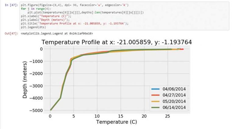
Using notebooks made it very simple for Brunner to employ an inquiry-based approach to teaching. For example, in a lesson on how to interact with image services, he began by asking how ocean temperature varies based on location, depth, and time of year. To answer that question, he showed students how to extract ocean temperature profiles from a multidimensional image service that is hosted in ArcGIS Online. Using a notebook, he walked students through all the steps and logic behind this process in a clear and well-documented fashion. It was also simple to incorporate popular scientific Python packages, such as Matplotlib and Seaborn, into the students’ workflow.
“The notebooks just work.”
The Benefits of Teaching with Notebooks
Brunner summed up in one sentence why he likes using ArcGIS Notebooks: “The notebooks just work.” He doesn’t have to worry about keeping passwords straight or installing all the right Python packages or making sure that all students have the same software and data. Students just log in and connect—no updating or troubleshooting local software. Notebooks can be created simply from an interface choice. The focus is on learning content, not tech support.
Sharing is a lot easier. In ArcGIS Online and ArcGIS Enterprise, notebooks can be shared as content items that are easy to find, are described, and are easily accessed without downloading. In ArcGIS Pro, notebooks are saved with the project, so notebooks are shared by sharing projects.
Easy Access to Technology Tools
Readily available to educators, ArcGIS Notebooks is included in the Esri Higher Education Institutional Agreement. Any university that has this agreement, already has access to ArcGIS Notebooks.
With ArcGIS Pro 2.5 and later, no additional license is required because ArcGIS Notebooks is part of the core product. For ArcGIS Online, the standard version of ArcGIS Notebooks is included with the organizational account. Simply create a custom role that includes privileges for working with ArcGIS Notebooks and apply that role to students. In addition to the standard option, there are two additional premium options for ArcGIS Notebooks that allow access to ArcPy modules and the GPU-enabled notebooks. For ArcGIS Enterprise, ArcGIS Notebooks is part of the server role for implementations of 10.7 or later. It requires Docker images, available from My Esri.
As course materials are updated, not only is the data updated but workflows in the notebooks can be easily revised. Notebooks can be shared as reproducible research, used as lessons across disciplines and research areas, and used to enlist citizen scientists to help make their contributions more valuable.
ArcGIS Notebooks expands learning opportunities because it lets students take work with them after they complete a course. Notebooks also enlarge the tools, methods, and materials available to instructors, who can integrate open science tools and experiences and use ArcGIS spatial analysis tools. Lessons can incorporate arcgis.learn, the deep learning module from the ArcGIS API for Python, as well as the machine learning capabilities available from within ArcGIS or from open source Python packages.
Educators can build lessons with access to a wealth of current data from the ArcGIS Living Atlas of the World and work with all types of data: imagery, multidimensional, tabular, unstructured data, vector, 3D, real-time data, big data, lidar, time series data, and full-motion video.
Take Advantage of Opportunities
Brunner urges educators to use technology and reimagine their courses and take advantage of the new tools and free content available from Esri and the Esri repository on GitHub, which contains many sample notebooks. “ArcGIS Notebooks [is] a great way to involve your students and enhance their learning by improving how students learn programming and strengthen their GIS analytical skills,” said Brunner.
About the author