This article provides GIS managers and analysts with an understanding of the fundamental concepts of Portal for ArcGIS and its capabilities. It presents a general overview of Portal for ArcGIS; discusses its key features, architecture, and implementation; and highlights the ArcGIS platform client applications that are available with Portal for ArcGIS.
Traditionally, GIS has been a technology used by analysts to perform spatial analysis and generate custom map products that meet the specific needs of their organizations. Although it was considered a niche technology, in recent years the concept and importance of spatial location have become more mainstream, and GIS awareness is now becoming more prominent in many organizations.
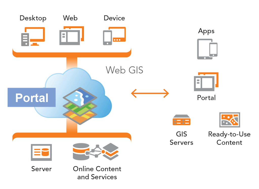
Web GIS is a pattern for delivering GIS capabilities. It is at the center of Esri’s strategic direction for implementing GIS as a platform. The key concept behind web GIS is that all members of an organization can easily access and use geographic information within a collaborative environment. Analysts still provide technical GIS expertise in the traditional sense, but other staff in the organization with little or no GIS knowledge can also benefit from and contribute to the organization’s GIS platform. Web GIS leverages existing GIS investments and makes them discoverable and more accessible. It provides a platform for integrating GIS with other business systems and promotes cross-organizational collaboration. Consequently, web GIS extends the reach of GIS to everyone in an organization, enabling better decision making.
At the center of the web GIS pattern in the ArcGIS platform is the generic concept of a portal that represents a gateway for accessing all spatial products in an organization. The portal helps organize, secure, and facilitate access to geographic information products. Client applications on desktops, web apps, tablets, and smartphones interact with the portal to search, discover, and access maps and other spatial content. In the back-office infrastructure, the portal is powered by two components: GIS servers and ready-to-use content.

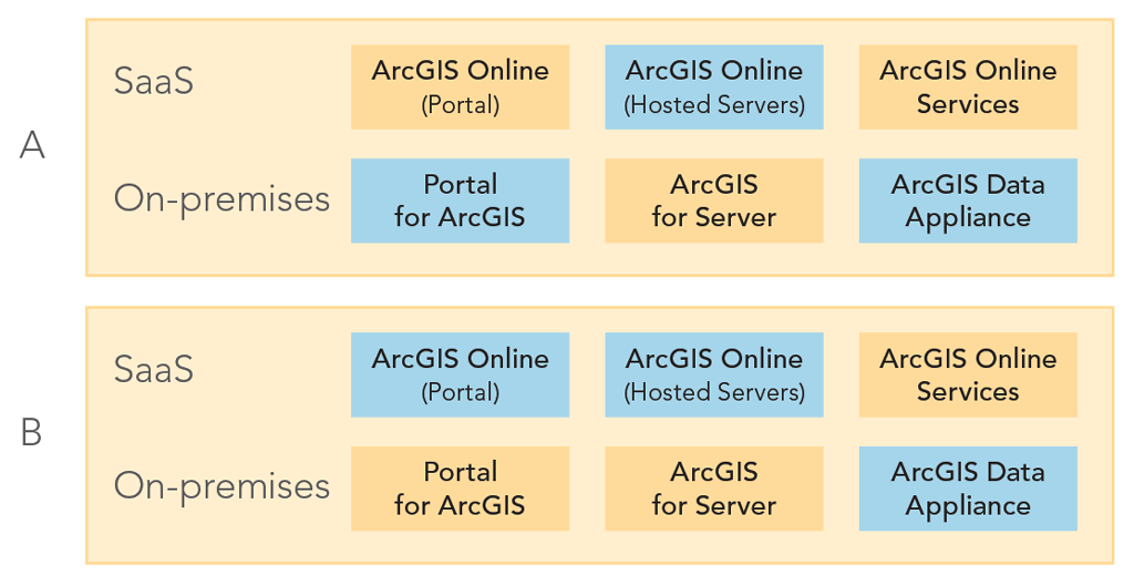
The ArcGIS platform offers two deployment models for web GIS. ArcGIS Online, the cloud-based offering, has a software-as-a-service (SaaS) deployment model. All components are hosted in the cloud. There is no hardware infrastructure for an organization to maintain because Esri manages and maintains ArcGIS Online. Alternatively, there is an on-premises model that includes Portal for ArcGIS. Portal for ArcGIS is deployed with ArcGIS for Server and optionally with the ArcGIS Data Appliance. In the on-premises model, an organization manages the hardware infrastructure to operate the ArcGIS platform.
Although there are two separate web GIS deployment models, hybrid deployments that combine parts of the cloud-based model with parts of the on-premises model are not only possible but very popular. These two common hybrid deployments are: ArcGIS Online + ArcGIS for Server + ArcGIS Online content and Portal for ArcGIS + ArcGIS for Server + ArcGIS Online content. Selecting the appropriate web GIS deployment model—SaaS, on-premises, or a hybrid variation—will depend on an organization’s business workflows and security requirements. Organizations can use one or several deployment models of the ArcGIS platform to enable web GIS to support their different lines of business.
What Is Portal for ArcGIS?
Portal for ArcGIS is a mapcentric content management system that an organization can host within its own infrastructure. Portal can be deployed on Windows or Linux operating systems and installed on an organization’s physical machines or in the cloud. It is software that enables an organization to deploy the portal concept of the web GIS pattern. An organization that installs Portal for ArcGIS would typically already be using ArcGIS for Server as part of its GIS operations and is responsible for the setup, configuration, and management of the portal.
Why Choose Portal for ArcGIS
There are several reasons why an organization chooses to implement Portal for ArcGIS instead of using ArcGIS Online for its web GIS portal. An organization may have sensitive data that cannot be uploaded and stored in the cloud. Perhaps the organization has unique security constraints and IT policies that can only be addressed by running the ArcGIS platform within the organization’s IT infrastructure. There may be requirements to honor strict service-level agreements that cannot be currently met with ArcGIS Online. The organization may work in an isolated/disconnected network environment that does not have Internet access. While Portal for ArcGIS offers many capabilities available in ArcGIS Online, some functionality may not yet be available because its development and release schedule follows that of ArcGIS Online.
Key Features
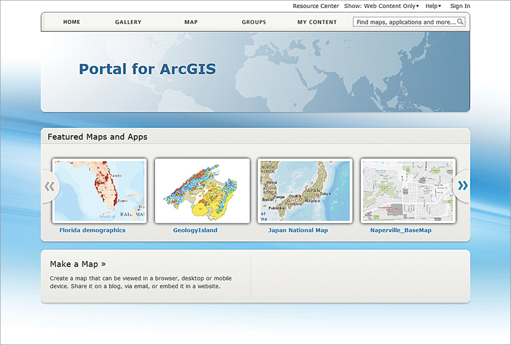
A common misperception is that Portal for ArcGIS simply provides a website for displaying GIS content that facilitates the search and discovery of spatial assets. It is much more than a website. While the website is the primary interface for Portal, it is actually a mapcentric content management system that provides a framework for the management of GIS content and promotes collaboration between staff within an organization. As a content management system, Portal for ArcGIS can register and store many common types of GIS content associated with ArcGIS such as web services, web applications, map documents, layer files, layer packages, geoprocessing packages, and shapefiles. It also supports many standard file formats such as comma-separated values (CSV); Adobe PDF; and Microsoft Word, Excel, or PowerPoint files.
When a web service, web application, or data file is registered or created in Portal for ArcGIS, it becomes a Portal item. An item defines a unique searchable element in the portal that has descriptive information associated with it and must be tagged with keyword(s). Depending on the type of GIS content added, in some instances, the GIS resource is simply being referenced and not physically moved into Portal. For example, items could be referenced to an online resource such as a web service or web application, or they can contain actual data such as a tile package or PDF document. Portal for ArcGIS can aggregate all of an organization’s GIS assets and related data files into a central location. It is a content management system for GIS resources that is easily searchable and accessible through the user-friendly Portal website.
Items in Portal for ArcGIS can be organized into Groups. Conceptually, a Group is like a folder containing a collection of items. A Group can also be empty and have no items (e.g., when a group is first created). Groups can categorize items for organizational purposes and be leveraged to control access to items. When an item is first created, it is private by default. Only the item owner can see and access it. The item owner determines if the item will be shared with a specific group or groups, with the organization, or with everyone (i.e., publicly accessible).
For example, item A is a registered web service, and item B is a PDF document that has been uploaded into Portal. Item A has been shared with the organization, but item B is only shared with the Survey group. Only members who belong to the Survey group are able to see and access item B, but all Portal members are able to see and access item A. Groups can be used to promote sharing and collaboration for specific items among certain staff in the organization and can be created for different departments, teams, business units, projects, organizational themes, or used to replicate the internal structure of the organization.

Portal for ArcGIS Map Viewer
A key aspect of the Portal for ArcGIS website is the map viewer. It provides an interactive means to perform mapping and visualization of GIS data. A user first selects a basemap, then searches for GIS content (typically web services) and adds them as operational layers (i.e., business information) onto the basemap. Optionally, the display properties of the operational layers can be configured such as setting transparency and symbology and activating and customizing pop-ups and attribute tables. Users can also add and display their own data, such as CSV, TXT, and shapefiles, on the map. The map viewer offers a simple and user-friendly mapping experience that makes it easy to find, assemble, and create map information products. It empowers those without GIS expertise to leverage GIS technology with their organization’s GIS assets in a very accessible manner that extends GIS technology to a broader user base.
Web Maps
After creating a map in the map viewer, a Portal member can save it as a web map. A web map is a container that stores map definition (e.g., layers, visibility, and extent) and behaviors (e.g., pop-up windows). The web map concept is an important part of the web GIS pattern and the ArcGIS platform. A web map is one of the mechanisms that promotes and facilitates sharing and collaboration in Portal for ArcGIS.
For example, a member named Bob creates a new web map in the map viewer, saves it, and shares it, making it available to other Portal members. Anne, a coworker, can open Bob’s web map in the map viewer and use it as a starting point for her own mapping visualization. She may add or modify the map contents, save it as a new web map, and share it with other members. Anne leverages Bob’s work, and they have both extended the organization’s GIS content by contributing back their data and analysis.
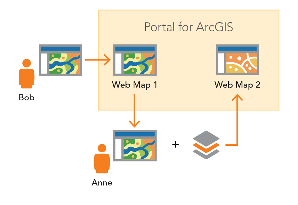
This workflow can continue and allow many Portal members to interact with and leverage the web maps stored in Portal. In effect, this is collaboration of spatial content based on maps. It is recommended that groups be used to help organize, filter, and govern the overall collection of web maps and other GIS content within Portal for ArcGIS. Portal members can also make web maps available to people outside Portal for ArcGIS by sharing with everyone and embedding web maps in HTML pages or directly sharing URL links to web maps with others.
Web maps work with all ArcGIS platform client applications: ArcGIS for Desktop, the ArcGIS web mapping APIs and viewers (JavaScript, Flex, and Silverlight), the ArcGIS mobile apps and APIs (iOS, Android, and Windows Phone), ArcGIS Runtime SDKs, and Esri Location Analytics products (e.g., Esri Maps for Office, Esri Maps for SharePoint, and Esri Maps for IBM Cognos). Web maps with custom map definitions and behaviors will all be honored in the ArcGIS platform client applications. The web map is an interactive display of geographic information that can be used to tell stories and answer questions across multiple platforms and devices and within many enterprise business systems. This further extends the reach of GIS assets within an organization.
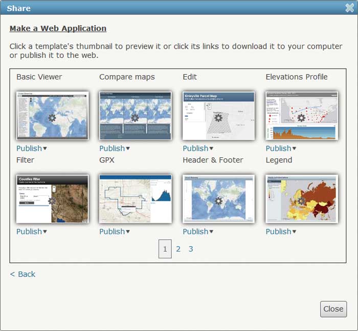
Application Templates
Portal for ArcGIS members can also build web applications for their web maps using the application templates included with Portal. With these templates, members can create and deploy new web mapping applications for a web map without any programming. Once a web map is saved and shared, a Portal member can select an application template, and the map’s data content populates the template to create a new web application. The web application can be hosted within Portal for ArcGIS, or its code can be downloaded onto a local machine and then hosted on an organization’s web server. Portal for ArcGIS includes many different application templates, and some can be further configured and customized. Each template is designed for a specific use case such as telling a story or answering questions.

Hosted Services
Portal for ArcGIS members can also add their own data to Portal to create a hosted web service. Two types of hosted web services are available: tiled map services and feature services. Tiled map services are typically used for static data. Feature services are typically used for dynamic data. A Portal member can add data to Portal to create a hosted web service under the My Contents section of the Portal website. ArcGIS for Desktop and Esri Maps for Office users can also connect to Portal for ArcGIS and publish GIS content to Portal as a hosted web service.
ArcGIS Online Content
Portal for ArcGIS also provides access to all nine basemaps available from ArcGIS Online: Imagery, Imagery with Labels, Streets, Topographic, Terrain with Labels, Light Gray Canvas, National Geographic, Oceans, and OpenStreetMap. Optionally, premium content from ArcGIS Online can also be used with Portal.
Architecture
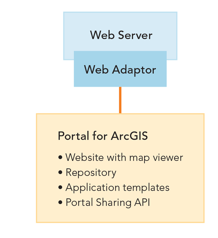
Portal for ArcGIS, an optional extension included with the ArcGIS for Server Advanced edition (Workgroup and Enterprise levels), is a different and separate installation from ArcGIS for Server. It requires installation of the ArcGIS Web Adaptor, which is included with ArcGIS for Server. The Web Adaptor integrates Portal with an organization’s web server architecture, enabling Portal to use an organization’s identity store and security policies at the web-tier level. Portal for ArcGIS includes its own identity store but also supports both Integrated Windows Authentication (IWA) and Public Key Infrastructure (PKI) authentication for logging into the Portal website and accessing its content. Portal for ArcGIS and ArcGIS for Server can be installed on the same machine or on separate machines.
A Portal for ArcGIS instance includes:
- The Portal website with map viewer
- A repository that contains the Portal content and index files
- Application templates that can be used to deploy web applications for web maps
- The Portal Sharing API, which exposes Portal for ArcGIS functionality as a REST endpoint and enables access to the ArcGIS Portal Directory
When installing and setting up Portal for ArcGIS, the first time you attempt to access the Portal website, you will need to specify an initial administrator account. You create this account when you initially log into and configure Portal for ArcGIS. This is not an operating system account. It only exists in the Portal for ArcGIS instance. After the initial configuration of your Portal instance, you can specify other accounts as administrators, demote the initial administrator account to a different role, or delete it.
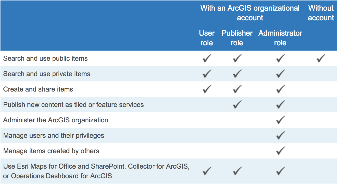
Portal for ArcGIS can be accessed with or without an ArcGIS organizational account. When you access Portal with an ArcGIS organizational account, you become a Portal member and can be assigned into one of three role types: Administrator, Publisher, or User. Portal for ArcGIS administrators control which role is assigned to a Portal member.
Portal for ArcGIS administrators can customize and configure many different properties of the Portal website and determine the functionality available. They can change the look and feel of the website home page, change gallery page settings, set featured groups, define the basemaps available in the map viewer, choose application templates, and set utility services. Utility services are the web services that power specific functionality in Portal such as printing maps, locating addresses, calculating area, and routing. Portal for ArcGIS includes some default web services from ArcGIS Online for utility services, but you can optionally use your organization’s web services to enable the utility services.
Integration with ArcGIS for Server
Portal for ArcGIS complements ArcGIS for Server because it provides an attractive front-end user experience for web services from an ArcGIS Server site. In addition, you can use ArcGIS Server web services to power Portal’s utility services such as geocoding, high-quality printing, and routing. Portal for ArcGIS can be integrated with ArcGIS for Server in three ways.
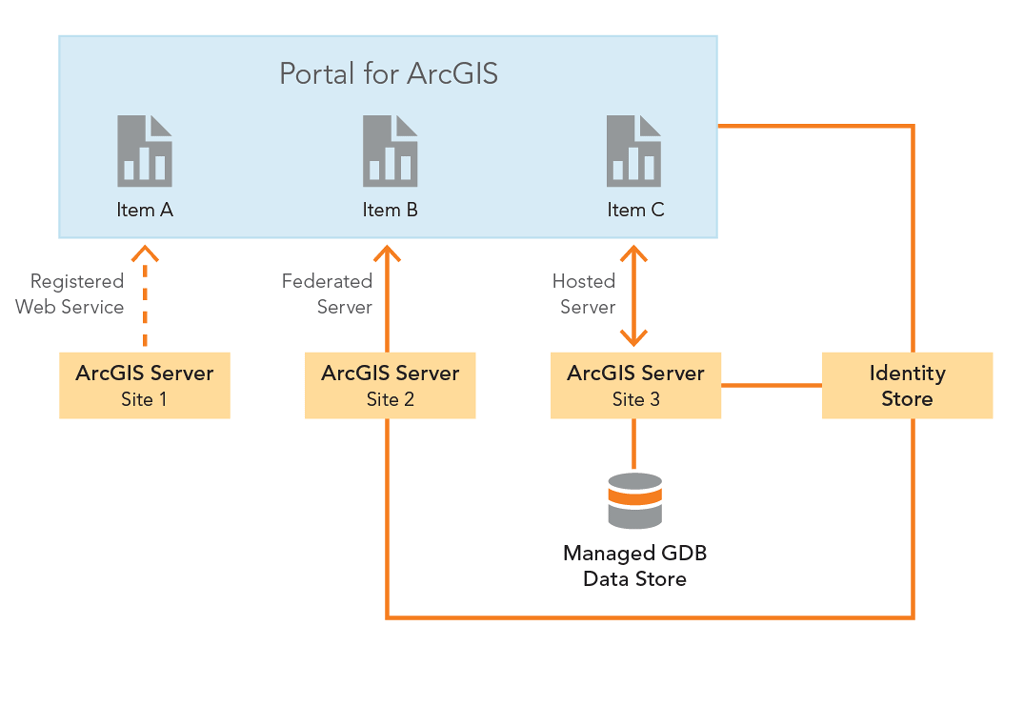
Portal for ArcGIS with Registered Web Services
You can register web services from an ArcGIS Server site with Portal by simply adding the web services as Portal items. The items reference the URL addresses of the web services. You can register both public and secured web services with Portal. For secured web services, you can optionally save the authentication credentials with the item or have users submit authentication credentials when they access it. Portal for ArcGIS and ArcGIS for Server are two separate entities, each with its own identity stores. Conceptually with this integration, Portal for ArcGIS and ArcGIS for Server are loosely coupled. Portal can have many registered web services from many different ArcGIS Server sites.
Portal for ArcGIS with a Federated Server
In this configuration, Portal for ArcGIS and ArcGIS for Server are more closely integrated. When you federate an ArcGIS Server site with Portal, it uses Portal’s identity store. This means that all Portal for ArcGIS members are now the only valid logins to the ArcGIS Server site. The ArcGIS Server site’s identity store is no longer used. Any web services that are published to the ArcGIS Server site will automatically be available as an item in Portal, and when users try to access the item, they will have a single sign-on user experience. Portal can be federated with multiple ArcGIS Server sites.
Portal for ArcGIS with a Hosted Server
In this option, you can configure a federated ArcGIS Server site to be a hosting server for Portal. This enables Portal members who are publishers to publish tiled map services and feature services to Portal. They can publish hosted web services directly in Portal, ArcGIS for Desktop, and Esri Maps for Office. The web services are hosted by ArcGIS Server on the back end. This option requires a multiuser geodatabase that is registered as a managed geodatabase data store for the federated ArcGIS Server site. Portal can only have one ArcGIS Server site as a hosted server.
A Portal for ArcGIS instance can use one or all of these integration options with ArcGIS for Server and with multiple ArcGIS Server sites. Selecting which integration option(s) to use will depend on your organization’s business workflows.
Clients to Portal for ArcGIS
All ArcGIS platform client applications work with web maps from Portal for ArcGIS. ArcGIS for Desktop and both the ArcGIS viewer applications (Flex and Silverlight) are good examples of clients that fully support web maps. Portal for ArcGIS leverages your existing GIS investments because you can register all your existing GIS web applications as Portal items. Several ArcGIS client applications have been designed specifically to work with Portal for ArcGIS (and ArcGIS Online).
- Esri Maps for Office provides mapping capabilities in Microsoft Office through an add-in. You can use this add-in with Microsoft Excel to create web maps in Portal that show data from Excel spreadsheets. Additionally, an add-in for Microsoft PowerPoint lets you embed these web maps into your presentations.
- Esri Maps for SharePoint provides mapping capabilities in Microsoft SharePoint through a map Web Part for SharePoint pages. You can use this to display content from Portal for ArcGIS in your SharePoint pages. It also includes a locate workflow that spatially enables SharePoint lists containing address data.
- Collector for ArcGIS is a field data collection and editing app for smartphones and tablets designed to help field staff rapidly collect and update data in the field using web maps from Portal for ArcGIS.
- Operations Dashboard for ArcGIS allows decision makers, operations managers, and section leaders to monitor activities and events; track their field work force; and assess the status of daily operations. The Operations Dashboard app creates and manages operation views within Portal. When members open an operation view in Portal, it downloads and installs the app on their computer.
These ArcGIS client applications extend the reach of your organization’s GIS assets in Portal for ArcGIS to a broader user base.
Summary
Web GIS is a pattern for delivering GIS capabilities and a key concept of implementing GIS as a platform. Portal for ArcGIS is a mapcentric content management system that enables an organization to deploy the portal concept of the web GIS pattern in its own infrastructure. Portal for ArcGIS is more than a website. It is a framework for the management of GIS content and promotes collaboration between users within an organization. Portal leverages existing GIS investments by making them discoverable and more accessible. By empowering people to use and create maps accessed from many client apps and platforms, it extends the reach of GIS to everyone in the organization, enabling better decision making.
About the author