ArcGIS Runtime SDKs 100.7 continues the track-focused development introduced with 100.6. This release expands capabilities for utilities and provides additional defense and public safety enhancements along with more platform-driven functionality.

Utility Networks
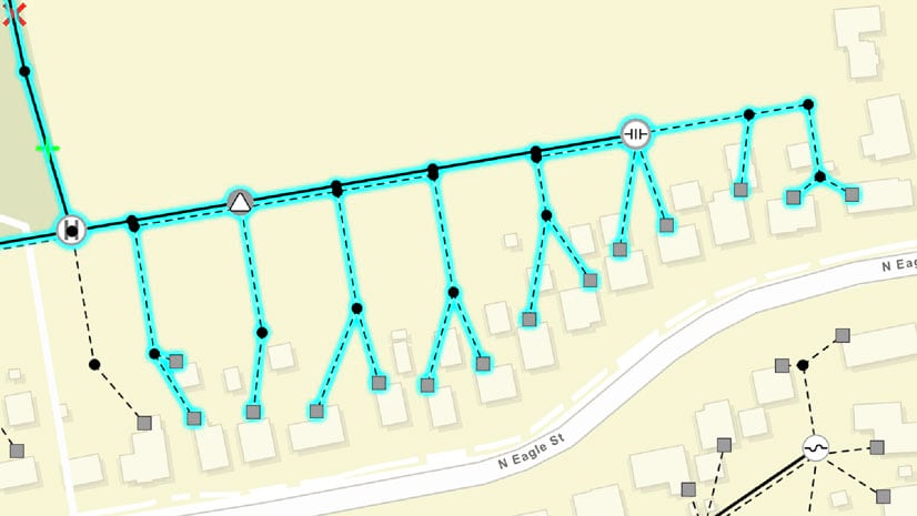
As a framework for modeling electric, gas, water, stormwater, wastewater, and telecommunications systems, utility networks demonstrate how features are connected and how dynamic devices are configured. Development for utility networks at 100.7 includes more network trace options and introduces the SubtypeFeatureLayer. While the SubtypeFeatureLayer is important for utility networks, it is beneficial anywhere subtypes are used.
With the 100.7 release of ArcGIS Runtime SDKs, subnetwork, downstream, and upstream traces have been added to provide a full suite of options. The subnetwork trace discovers all features that participate in a subnetwork (i.e., a logical subset of the network such as a circuit or a zone). The downstream trace option finds out what is being fed from a specific part of the network. The upstream trace is useful to discover what’s feeding a specific part of the network.
Building on the foundation introduced at 100.6, ArcGIS Runtime SDKs now supports a much richer collection of tracing options. Traces can be configured to stop based on complex attribute expressions or function barriers. Advanced attribute propagation is also supported so phase-based electrical traces can be authored. Connectivity associations and structural attachment associations can now be queried, and additional utility network schema information is available. Consequently, ArcGIS Runtime SDKs can now serve as the basis for truly powerful utility network field apps.
An ArcGIS Utility Network Management extension maintains real-world network element types, such as fuses, transformers, and switches, as subtypes in a single feature class. This benefits performance but can be challenging when customizing how each subtype is presented to the user as pop-ups or visible scale ranges, for example.
The new SubtypeFeatureLayer provides a clean solution for these challenges. When pointed at a single feature class, it acts as a group layer that automatically includes a feature layer for each subtype in the source feature class. These sublayers can be configured independently of one another, and queries are optimized across all sublayers. For example, a pan of the map sends a single request to the source feature class to cover all the sublayers. (Note: Manually creating a feature layer for each subtype would have resulted in a query per feature layer.)
Access to utility network data and analysis (e.g., tracing) now requires an extension license. However, the extension is not needed during development, only when deploying an app for production use. For named users, the Utility Network user type (available with ArcGIS Enterprise 10.8) can be added to a named user. A new ArcGIS Utility Network Management license key can be purchased for ArcGIS Runtime SDKs deployments. In either case, the extension enables licensed access to utility network functionality in the ArcGIS Runtime SDKs.
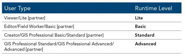
With the upcoming release of ArcGIS Enterprise 10.8, a new user type will be introduced for ArcGIS Utility Network Management extension, which covers the capabilities of utility networks across the platform. ArcGIS Runtime SDKs utility network licensing is rolled into the Utility Network user type and included with GIS Professional Standard and GIS Professional Advanced user types. It can be assigned as an add-on to all other user types, although the Viewer user type will be limited to viewing and tracing utility networks.

Augmented Reality
Tabletop was one of the three augmented reality (AR) modes introduced with the ArcGIS Runtime 100.6. With this mode, the developer provided a scene to the ArcGIS Runtime Toolkit’s AR component and determined the surface on which to place it. With version 100.7, the scene can be clipped for a better fit to the surface specified. In addition, various optimizations for downloading scenes more quickly and efficiently were incorporated. Other improvements enable
- Use of a map’s reference scale with graphics overlays.
- Use of scale-based symbol classes for layers delivered via mobile map packages (MMPKs).
- Working with Preplanned Areas defined by polygons.
- Use of custom styles for vector tile package (VTPK)-based layers in MMPKs.
Defense and Public Safety
Improvements for the defense and public safety track enhance symbology and working offline. Marker symbols draped on the ground in 3D scenes can be displayed either billboarded or flat. Mobile scene packages (MSPKs) can include rasters as elevation sources and transportation networks. Rasters can be read directly from an MMPK or MSPK without unpacking it. ArcGIS Runtime apps can now also create and edit KML screen overlays. Previously, KML files could only be displayed.
Licensing by User Type
User types can now enable all levels of ArcGIS Runtime licenses via an ArcGIS Online or ArcGIS Enterprise named user login. Named user logins now enable Standard and Advanced level licenses. A new Runtime Analysis extension can also now be assigned as an add-on to Creator and GIS Professional user types. These user types include a Runtime Standard or Advanced license.
Also Included in 100.7
In addition to bug fixes, improvements, and optimizations, new samples have been added to the SDK samples apps, and the guide and reference docs have been updated. The open-source apps team has updated the Data Collection .NET WPF [Windows Presentation Foundation] app with new functionality to bring it in line with the Data Collection iOS app. The team has also released a new version of the Data Collection .NET UWP [Universal Windows Platform] app.
Please note: There is no update to Local Server at 100.7.
See the release notes for each individual SDK (Android, Qt, .NET, Java, and iOS ) for more details.
Download It and Get Started
To get 100.7, go to the ArcGIS for Developers website, browse the ArcGIS Runtime page of your choice, and download the SDK. You can also reference ArcGIS Runtime through NuGet, Gradle, or CocoaPods. If you’re new to developing with ArcGIS Runtime and don’t have an ArcGIS for Developers subscription, visit the ArcGIS for Developers website and sign up for a free account. You’ll be able to access everything you need to develop your apps.
About the authors

Nick Furness