Preparing for an eight-day excursion into some of the most remote areas in the world takes time and careful planning under any circumstances. For the Bureau of Land Management’s (BLM) Assessment Inventory Monitoring (AIM) team, this task comes with added challenges that include preparing and packing the host of equipment needed to assess natural resource conditions across the 245 million acres of US public lands that BLM manages.
The enormity of the area being monitored—10 percent of the entire land base of the United States—presents no small challenge. Every year, crews of three to five AIM team members gear up and head into the field to collect large samples of data that will later be used to inform policy and decision-making in the BLM’s mission: “to sustain the health, diversity, and productivity of public lands for the use and enjoyment of present and future generations.”
Doug Browning, a geospatial systems architect with the Sanborn Map Company who is a BLM contractor, relies on a foundation of ArcGIS technology in his work to support the AIM team. He is also an Esri Community MVP, who has contributed thousands of posts and hundreds of solutions helping other users with GIS challenges over the years.
Browning designs and manages large integrated workflows that combine ArcGIS Online, ArcGIS Field Maps, and ArcGIS Survey123. His ArcGIS-enabled applications provides navigation to isolated survey sites, capture massive datasets over repeated day-long assessments, and convert that data into useful information that’s linked to location.
Forms Built for a Huge Task
Browning concentrates on building the ArcGIS Survey123 forms that AIM team members will use in the field to enter data at each location they visit. He’s designed this suite of forms so that they remain applicable regardless of the area and environment they’re being used in, while leveraging the ability of ArcGIS Survey123 to account for key differences across locations.
Once AIM team members are on-site, ArcGIS Field Maps is used to launch ArcGIS Survey123 and pass configuration variables and other parameters, which allows forms to adjust on the fly. This means that the team needs just one form for the entire nation. While forms don’t have to be adjusted by state, they can be adjusted by state.
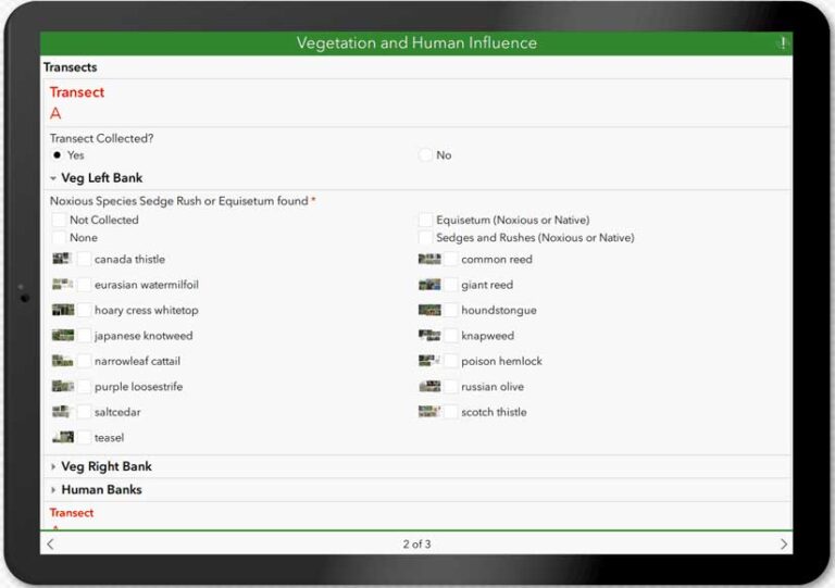
Each form can have its own species list and that list can vary from from 20 to 30,000 species. Plants classified as native in one state can be classified as invasive in another state, so categories must be dynamic.
Team members work one of the three AIM programs that collect and enter data. They visit approximately 8,000 sites and collect 100,000 images per season. At each location, they complete a series of 10 to 15 surveys. Breaking up the surveys this way is intentional. It enables team members to enter data on their own tablets simultaneously, while filling in the 1,700 fields that must be completed by each program for each site visited. These forms represent some of the most complex and intricate examples that Esri’s ArcGIS Survey123 team has seen put into action.
Collaborating with the ArcGIS Survey123 Team
ArcGIS Field Maps, ArcGIS Survey123, and ArcGIS Dashboards aren’t the only Esri products in Browning’s toolkit. If you are a member of Esri Community, you may have benefited from his expertise.
When asked how he first started using Esri Community, Browning described himself as having been someone who always reads through official help documentation and scours message boards to help him learn and solve challenges. While both resources are valuable, he finds differences in what the two resources offer users, and that’s what makes Esri Community particularly valuable to him.
“I think the Community is that window into what’s going to work in real-life situations or might work in a kind of a funky situation,” he said.
He’s also seized the chance to collaborate with Esri staff directly in the platform, particularly when it comes to exchanging ideas and insights with the ArcGIS Survey123 team. He did a lot of back-and-forth with the team.
“In my 30 years of software development, I’ve never had that kind of interaction, and that all came from Esri Community,” Browning noted.
The benefits flow both ways. Browning has shared his own hands-on experience with Esri product teams through the ArcGIS Ideas and improve ArcGIS Survey123. In some cases, this has helped fuel new features that are then available to all users.
A Team of Peers and Pros in Esri Community
Browning has published thousands of posts over the 10 years he has been using Esri Community. Nearly 400 of his posts have become Accepted Solutions that have helped other users overcome difficulties and solve problems. Due to his high degree of engagement and contributions, Browning became an Esri Community MVP in 2021.
“I always learn a lot. It improves what I do,” he said as he reflected on what it’s meant to not just receive help in Esri Community, but to also spend time offering help back to others. “It gives me problems that I might not normally have and encourages me to work with techniques that I might not have used before.”
He describes Esri Community as “almost like living documentation.” It deals with real work problems. “Esri Community is giving story problems; continuously testing your skills to really branch out your knowledge.”
To ArcGIS users who haven’t yet joined Esri Community, Browning encourages them to get involved. He observed, “We’re going alone. I mean, why wouldn’t you want a whole team of real experts there to help you?”
Watch This Interview of Doug Browning (5:47)
About the author