The Idaho Transportation Department (ITD) employed mobile vehicle-based data collection and automated data extraction methods to speed and standardize the statewide inventory of its highway system.
The timely, accurate, and complete acquisition of highway transportation asset data, such as signs and guardrails, was a long-time goal of ITD. Visualizing and analyzing geospatial data improves and expedites highway infrastructure planning, operations, and design projects.
Over the years, ITD also acquired a variety of spatial data-based applications to improve its capabilities but often had insufficient data to effectively utilize these tools. Further, the lack of a reliable highway inventory was sometimes noted in legal issues when ITD was unable to demonstrate knowledge of the assets under scrutiny.
Even with GPS technology, gathering asset data along ITD highways remained a time-consuming, manual “boots-on-the-ground” process. Each of ITD’s six semiautonomous administrative districts collected data using different methods and timetables. Data collection typically had to be distributed across numerous ITD staff, thereby introducing consistency issues. Due to the staggering time investment needed to perform inventories, they were often done in piecemeal fashion or were not finished. Even when inventories were completed for a district, there were no standard methods for updating them, so inventories frequently went stale.
This scenario likely sounds all too familiar to anyone who deals with GIS transportation data and its management. Limited resources and the intense focus on delivering roadway infrastructure projects often means data collection efforts fall to the wayside or slip into the margins of projects.
To rectify this shortfall of roadway asset data, transportation departments across the United States are increasingly relying on mobile vehicle-based data collection and automated data extraction methods. These are typically provided by specialized vendors utilizing technologies such as lidar, high-resolution roadway photography, and automated intelligence software for efficient data-gathering methods that provide accurate data. Mobile technologies can be used by any organization that is responsible for roads or road maintenance, including those at the city or county level. Utility and communications companies, or other industries with assets located along linear routes, can benefit from these processes.
In summer 2018, ITD initiated a pilot project called the Statewide Asset Attribute Inventory (SWAAI, pronounced “sway”) to remedy its data-gathering issues and move ITD forward in its data practices. The project collected vehicle-based lidar and roadway photography data for Idaho’s entire state highway system. Following its collection, the data was used to extract a list of deliverable Esri geodatabase feature class roadway asset inventories according to ITD’s specifications.
Preliminary Planning
During the SWAAI project’s first year, similar projects and capabilities previously undertaken by other state Departments of Transportation (DOTs) were investigated. Early discussions with Utah DOT staff provided insight into the extent of data collection options as well as sample documentation. Utah had conducted similar projects for years and had a running record of many of its assets. Armed with a stronger understanding of new-technology data collection methods, a data dictionary of asset types, and associated attributes, the SWAAI project team had a better understanding of what could be accomplished by its mobile data collection project.
Initially envisioned as a project limited to mobile data gathering for a single district, the project was expanded statewide following a recommendation from ITD headquarters. In summer 2019, as project planning progressed, ITD’s District 5 formally partnered with the ITD headquarters Roadway Data section and its IT group with the goal of building a standard ITD data framework and ultimately selecting a vendor to provide the collection services and data.
A statewide ITD data stakeholder team was organized with a central core committee to guide the project and an extended, continually growing group of interested ITD staff from fields across the organization. These stakeholders were kept in the loop with a series of monthly emails as well as invitations to training activities and presentations. This mailing list grew from 100 to more than 300 recipients over the course of the project.
Throughout the next year, the SWAAI project team compiled and prioritized data needs, prepared and issued a request for proposal (RFP), and conducted two rounds of meetings in each ITD district and headquarters. A business analyst consultant was brought in to help facilitate these discussions, build on the data standards, and prioritize the asset data types most important to ITD staff.
ITD issued its RFP in March 2020 and spent the next few months answering questions from potential vendors and evaluating the proposals that were submitted. Five SWAAI team members selected the vendor based on the following criteria: knowledge/experience, data quality/consistency, available resources, and innovation/value adds.
Project Launch
Cyclomedia Technology, an Esri partner with a strong understanding of GIS technology, was selected from the 11 vendors who submitted proposals. The next step was negotiation. ITD had considered its data dictionary of about 30 asset types as a wish list and anticipated only 12 to 15 key data items could be included given the project’s $2.5 million budget. However, Cyclomedia surpassed all ITD’s expectations and delivered 28 feature classes.
In addition to the wide breadth of data types, the asset list included significant depth in attribution. The ability to perform drive-by inspections of curb ramps and sidewalks to ensure conformance with the requirements of the Americans with Disabilities Act (ADA) was an intriguing possibility going into the project.
As it turned out, this was fully feasible. Lidar data gathered during the project produced a 3D model of ITD’s entire state highway system at a high degree of point-to-point accuracy (±0.79 inches, or 2 centimeters), allowing for reliable measurements of everything on the road, from guardrail heights to lane widths.
Lidar- and photo-collected data from all 7,200 miles of Idaho’s state highway system was acquired in less than three weeks in July 2020. Cyclomedia began extracting the 28 asset feature classes immediately after data collection and delivered the results to ITD each month as a series of geodatabases for quality assurance purposes. ITD GIS staff around the state reviewed the data and provided feedback to Cyclomedia.
Early in the project, it was vital to identify the refinements needed to Cyclomedia’s semiautomated data extraction process to meet ITD specifications. Issues such as approach (driveway) pavement status, guardrail post materials, and lane configuration definitions were clarified and rectified through this process.
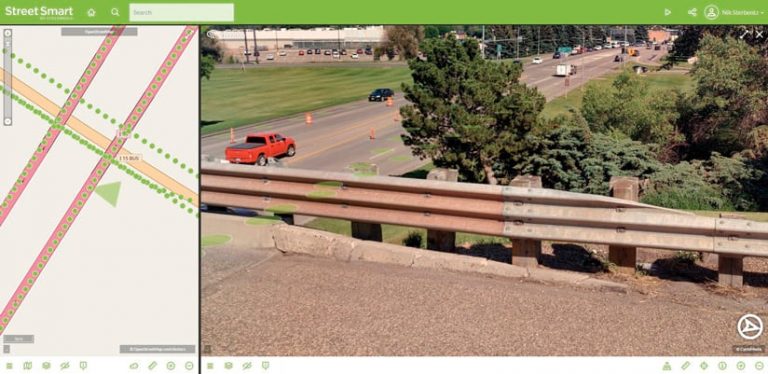
Browser-Based Access to Data
Apart from asset data, another key—but unexpected—aspect of the SWAAI project was Cyclomedia’s Street Smart, a browser-based viewer, which made the 360-degree roadway photography and lidar accessible. Equipped with measuring tools that allow for ad hoc measurements directly from the high-resolution imagery, ITD users quickly discovered many use cases for Street Smart. Although this project value add was provided by Cyclomedia on a complimentary basis, it became a key tool for promoting the project to ITD staff.
Street Smart provided a solid visual representation soon after vehicle-based collection was completed, immediately showing stakeholders the rapid progress being made. Street Smart use spread like wildfire. More than 300 interested ITD staff attended Cyclomedia-led trainings to learn how best to leverage its viewing, measuring, and sharing capabilities.
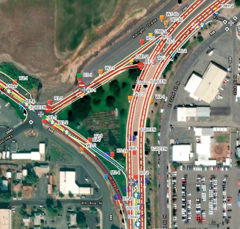
For ITD GIS staff, one of the most exciting aspects of Street Smart was its integration with the extracted GIS feature data. Every GIS feature linked to Street Smart provided a view of its location in street-level imagery and focused the camera viewpoint on that feature. The online GIS web application allows users to zoom in to a view of each sign, guardrail, or bridge clearance.

Making Data Available
Making data available in a timely fashion to the people who need it was a project priority. Data usefulness depends on its accessibility. Having all data as geodatabase feature classes makes the data usable across a wide variety of geospatial and CADD applications and allows it to be easily exported to tabular formats.
In March 2021, copies of the final geodatabase delivered by Cyclomedia were provided to each of ITD’s six district. ArcGIS Online tools were available to ITD and provided the SWAAI data to its stakeholders. The full geodatabase was published to ArcGIS Online as a feature service. Online GIS mapping applications showcasing the data are featured on the ITD SWAAI ArcGIS Online hub site.
ArcGIS Hub was ideal for presenting the data on multiple levels. It served as an information tool for describing project methods, progress, and other information. SWAAI’s business analysis—including the complete data dictionary and potential use cases for each data type—are also displayed, along with specifications on Cyclomedia’s data collection, extraction, and Street Smart.
Ultimately, the hub site became a data showcase, providing an amazing level of detail and revealing fascinating statistics and patterns. For example, more than 90 percent of the objects crossing ITD highways are utility lines. Data on these assets was not previously collected. The number of specific signs or pavement markings can quickly and accurately be determined. Previously this would have been all but impossible. Highly detailed ADA curb ramp and sidewalk information is available from a series of pie charts, and intersections are placed in relation to their subintersection legs, traffic signals, junction boxes, and power pedestals. This is a wealth of data available for ITD staff, partners, and the public to explore.
The Value of SWAAI
The SWAAI data and hub site were presented at the ITD Program Delivery Conference in April 2021. The level of enthusiasm surrounding the SWAAI project was palpable. Reliable data was needed for a long time, and it was finally delivered. By one estimate, SWAAI saved nearly 300,000 hours of personnel data collection and an estimated $3.8 million in maintenance staff wages.
However, the surprise was just how immediate and far-reaching SWAAI benefits are. One of the earliest and most intensive uses of the data came from the ITD HQ Planning Services division. Over the years, ITD has struggled to maintain its ADA compliance data on accessible curb ramps and sidewalks. The consistent, efficient, repeatable, and cost-effective method of data collection pioneered by SWAAI avoids expensive and time-consuming inspections. Now, curbs and ramps can be categorized as those in compliance, those that can be cost-effectively retrofitted, and those that need replacement. This return on investment is an impressive example of the power of GIS data.
ITD staff, led by district GIS analysts, are finding innovative ways to leverage the new data that ranges from speed zone analysis to identifying the locations of all incorrectly sized stop signs that need replacement. SWAAI data is also being used to provide estimates of the number of guardrails, signs, or other materials required for infrastructure projects. Processed lidar point cloud data is also available for ITD planning and design staff, who can use it to generate topographic surfaces for CADD drawings.
The Future of SWAAI
Following the statewide success of this enterprise data-gathering venture, ITD is planning to refresh the data every three years going forward. Today, conversations surrounding maintenance, standards, ownership, and other data governance considerations are being had across the organization. Prior to the SWAAI project, these discussions were hypothetical because they were based on data gathered sometime in the future. Having this volume of data in hand has elevated these discussions from vague desires to a tangible reality made possible today by geospatial technology.
For more information, contact Nik Sterbentz at Nikolaus.Sterbentz@itd.idaho.gov.
About the author